
-
Research Article
-
A Study on Design Improved Method for Economical Design of Cast-in-Place Lining for Expressway Tunnel
고속도로 터널 현장타설 라이닝의 경제적인 설계를 위한 설계 개선방안 검토 연구
-
Tae Hyun Lee, Heui Soo Han
이태현, 한희수
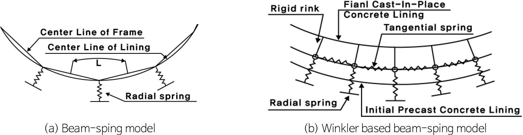
- In Korea, the design of cast-in-place linings for highway tunnels predominantly follows the ultimate strength design (USD) method. However, the growing demand …
국내 고속도로 터널 현장타설 라이닝의 설계는 대부분 강도설계법(ultimate strength design, USD)을 적용한다. 하지만, 지속적인 경제적인 설계와 시공이 요구에 따라 한계상태설계법(limit state design, …
- In Korea, the design of cast-in-place linings for highway tunnels predominantly follows the ultimate strength design (USD) method. However, the growing demand for more economical and efficient design and construction has led to the need to introduce the limit state design (LSD) approach. Although there have been domestic design cases and research adopting LSD, most have applied standards originally intended for bridges and road structures, and have mainly focused on segmental lining designs. In 2017, AASHTO introduced the first tunnel design standard based on the load resistance factor design (LRFD) method, a form of LSD. However, its application in Korea remains limited. Therefore, this study examines the applicability of the LRFD method by comparing a design based on the conventional USD method with an improved design using LRFD. The comparison showed that the moment in the lining was reduced by 50%, and the axial force by 52%. Furthermore, the review of the P-M interaction diagram indicated a resistance strength of 109% relative to the ultimate load. Based on these results, the design adequacy was verified, and it was concluded that LRFD can prevent overdesign and enable a more rational and cost-effective tunnel lining design.
- COLLAPSE
국내 고속도로 터널 현장타설 라이닝의 설계는 대부분 강도설계법(ultimate strength design, USD)을 적용한다. 하지만, 지속적인 경제적인 설계와 시공이 요구에 따라 한계상태설계법(limit state design, LSD)의 도입이 요구되는 실정이다. 한계상태설계법(LSD)을 도입한 국내 설계 및 연구는 있지만 대부분 교량과 도로구조물 등에 대한 한계상태설계법(LSD) 기준을 차용하여 터널에 적용하였고, 세그먼트 라이닝 설계에 국한하여 수행되었다. 2017년도 AASHTO에 의하여 한계상태설계법(load resistance factor design, LRFD)을 적용한 최초의 터널 설계기준이 제시되었으며, 이는 국내에 적용된 사례가 드문 실정이다. 따라서 본 연구에서는 기존 강도설계법(USD)을 적용하여 수행된 설계와 한계상태설계법(LRFD)을 적용하여 개선된 설계를 비교하여 한계상태설계법(LRFD)의 적용성을 검토하였다. 검토 결과, 라이닝에 발생하는 모멘트는 50% 감소하였고, 축력은 52% 감소하는 것으로 나타났다. 또한 P-M 상관도를 검토한 결과, 극한하중대비 109%의 저항강도를 보였으며, 이에 따라 적정성이 검토되었으며, 과다설계를 방지하여 보다 합리적이고 경제적인 설계가 가능할 것으로 검토되었다.
-
A Study on Design Improved Method for Economical Design of Cast-in-Place Lining for Expressway Tunnel
-
Research Article
-
Gravity Field Interpretation and Modeling to Understand the Sinkhole in Myeongil-dong, Gangdong-gu, Seoul
중력장 해석과 수치해석을 통한 서울시 강동구 명일동에서 발생한 땅꺼짐의 원인 고찰
-
Sungchan Choi, Dae-Hong Go, Yeong-Jae Lee, Eun-Kyeong Choi, Sung-Wook Kim
최승찬, 고대홍, 이영재, 최은경, 김성욱
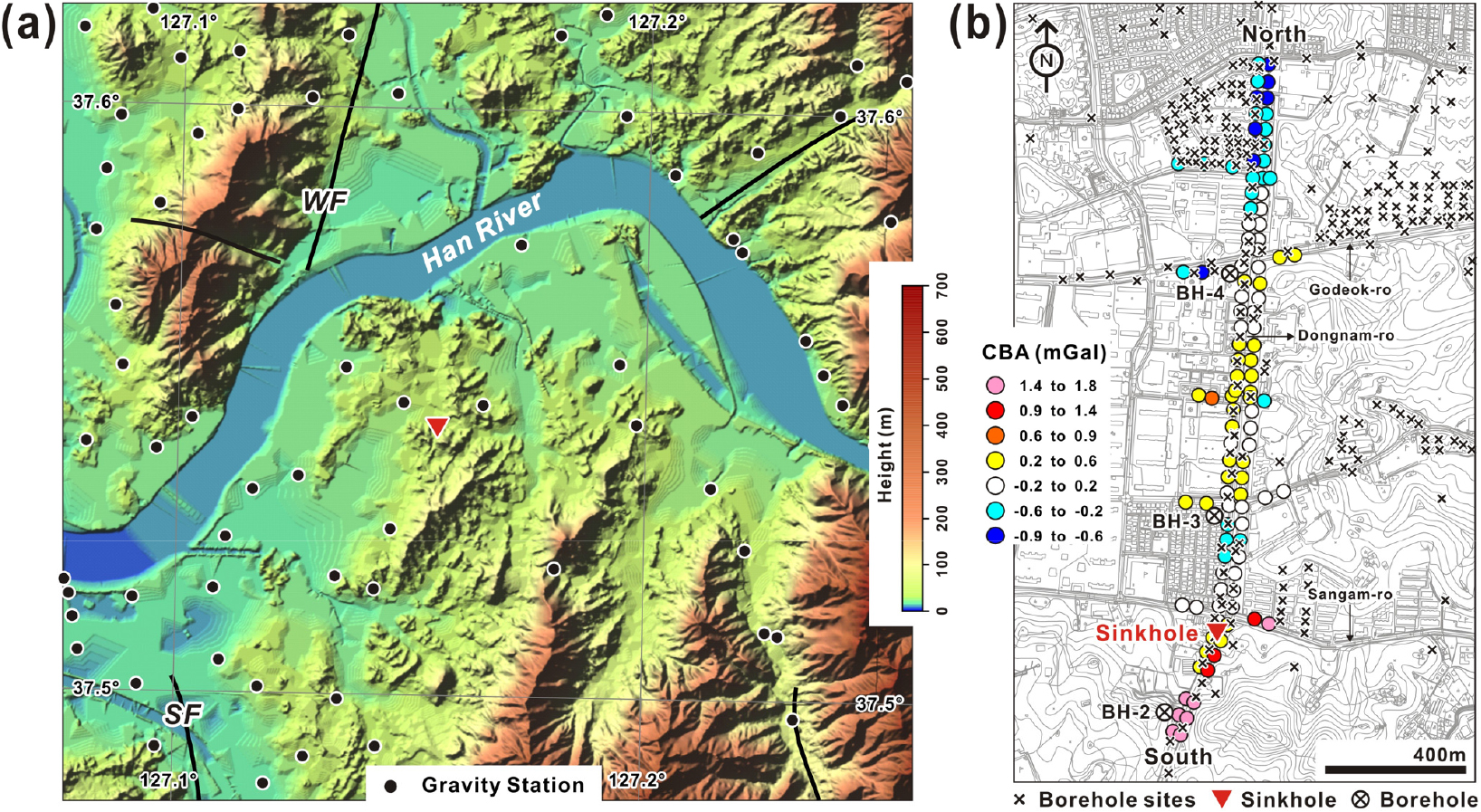
- The cause of the large sinkhole that occurred on 24 March, 2025 in Myeongil-dong, Gangdong-gu, Seoul, was identified through gravity field interpretation …
중력장 해석과 밀도 모델링을 이용하여 2025년 3월 24일 서울시 강동구 명일동에서 발생한 대형 싱크홀(sinkhole)의 원인을 파악하였다. 연구결과, 땅꺼짐은 자연적 원인으로 충적층에 피복된 …
- The cause of the large sinkhole that occurred on 24 March, 2025 in Myeongil-dong, Gangdong-gu, Seoul, was identified through gravity field interpretation and subsurface density modeling. The sinkhole is thought to have originated in a low-density zone presumed to be the damage zone of a concealed fault covered by alluvial deposits, indicating a natural cause. In addition, anthropogenic factors, including leakage from underground pipes and excavation, are thought to have contributed to the incident. Over the long term, the fault appears to have facilitated the development of a deeply weathered zone conducive to moisture retention, while associated fractures provided favorable hydrogeological conditions for groundwater movement. In the short term, leakage from water and sewage pipes, along with underground excavation, accelerated the formation of the sinkhole. The surface collapse is thought to have occurred as low-density soil migrated into the tunnel under excavation along the fault damage zone.
- COLLAPSE
중력장 해석과 밀도 모델링을 이용하여 2025년 3월 24일 서울시 강동구 명일동에서 발생한 대형 싱크홀(sinkhole)의 원인을 파악하였다. 연구결과, 땅꺼짐은 자연적 원인으로 충적층에 피복된 숨은단층의 손상대로 추정되는 저밀도층에서 발생하였으며, 지중 관로의 누수와 굴착 등의 인위적인 원인이 복합적으로 작용한 결과로 해석된다. 지층붕괴는 장기적으로 단층의 영향으로 수분 저장이 용이한 깊은 심도의 풍화대가 발달하였고, 단열은 지하수가 이동하기 쉬운 수리적 조건을 제공하였다. 단기적으로 상 ‧ 하수관로 등의 누수와 지하 굴착은 땅꺼짐을 촉진하는 요인으로 작용하였고 지표면 함몰은 저밀도의 토사층이 단층 손상대를 따라 굴착 중인 터널 내부로 흘러내리는 과정에서 발생한 것으로 판단된다.
-
Gravity Field Interpretation and Modeling to Understand the Sinkhole in Myeongil-dong, Gangdong-gu, Seoul
-
Research Article
-
Stability of Landfill Sites Reinforced Using the Compacted Earth Method
압성토로 보강에 따른 폐기물 매립지반의 해석적 검증에 관한 연구
-
Wooyoul Lee, Seokjin Oh, Hyeok Seo
이우열, 오석진, 서혁
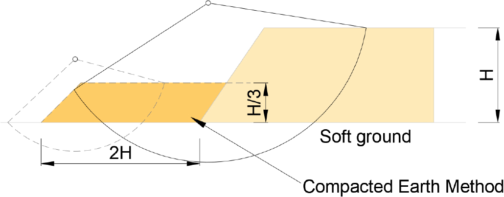
- Landfill stability is a critical issue in geotechnical engineering, particularly the seismic resistance of landfill sites. We evaluated the seismic stability of …
폐기물 매립지의 안정성은 지반공학에서 중요한 연구 주제이며, 특히 내진 성능에 대한 검토가 필수적이다. 본 연구에서는 압성토 공법을 적용하여 매립지의 내진 안정성을 평가하였다. …
- Landfill stability is a critical issue in geotechnical engineering, particularly the seismic resistance of landfill sites. We evaluated the seismic stability of landfill sites that use the compacted earth method, a counterbalance reinforcement technique. A series of 1 g shake table tests were conducted to examine the dynamic response of landfill slopes reinforced with compacted earth. Peak ground acceleration (PGA) was measured at different depths, and numerical simulations were performed to verify the experimental results. Our results indicate that reinforcement significantly reduces seismic amplification, with greater stability observed with 15 m of compacted earth reinforcement compared with 10 m of reinforcement. Our study also highlights discrepancies between experimental and numerical analyses, suggesting the need for further refinement in seismic response modeling. These results provide valuable insights into methods of improving landfill stability during seismic events.
- COLLAPSE
폐기물 매립지의 안정성은 지반공학에서 중요한 연구 주제이며, 특히 내진 성능에 대한 검토가 필수적이다. 본 연구에서는 압성토 공법을 적용하여 매립지의 내진 안정성을 평가하였다. 1g 진동대 시험을 통해 압성토 보강이 적용된 매립지 사면의 동적 응답을 분석하였으며, 가속도계(peak ground acceleration, PGA) 값을 깊이별로 측정하고 실험 결과를 검증하기 위해 수치 해석을 수행하였다. 연구 결과, 압성토 보강이 지진 시 지반의 증폭률을 감소시키는 효과가 있으며, 특히 15 m 보강이 10 m 보강보다 더욱 안정적인 거동을 나타내는 것으로 확인되었다. 또한, 실내 실험과 수치 해석 간의 차이를 분석하여 내진 응답 해석 모델의 개선 필요성을 제시하였다. 본 연구 결과는 폐기물 매립지의 내진 성능 향상을 위한 기초 자료로 활용될 수 있다.
-
Stability of Landfill Sites Reinforced Using the Compacted Earth Method
-
Research Article
-
The Dynamic Behavior of Soft Ground Reinforced with Gravel Compaction Piles
쇄석다짐말뚝 보강에 따른 연약지반의 동적 거동특성 분석
-
Seob Lee, Hyeok Seo, Daehyeon Kim
이섭, 서혁, 김대현
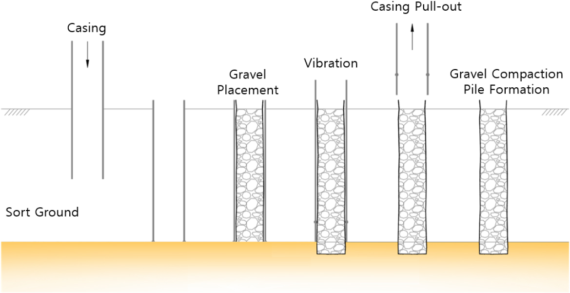
- We investigated the dynamic behavior of soft ground reinforced with gravel compaction pile (GCP) using 1 g shake table models. We constructed …
본 연구는 쇄석다짐말뚝(gravel compaction pile, GCP) 보강이 연약지반의 동적 거동에 미치는 영향을 분석하기 위하여 1g 진동대 실내모형실험을 수행하였다. 실험은 무보강 지반과 GCP로 …
- We investigated the dynamic behavior of soft ground reinforced with gravel compaction pile (GCP) using 1 g shake table models. We constructed both unreinforced and GCP-reinforced experimental models with accelerometers installed at multiple depths to measure acceleration under various seismic inputs. A total of five ground motion patterns were applied: the Ōfunato, Hachinohe, Gyeongju, and Pohang waves and an artificial wave. We analyzed peak ground acceleration (PGA) to evaluate the amplification characteristics and used response spectra to assess the reinforcement effects quantitatively. The PGA analysis revealed that the mean amplification ratio between the base and the top of the unreinforced models was 61.57%. When GCP reinforcement was applied, the amplification ratio decreased to >41.23%, representing a maximum reduction of 20.34%. The mean acceleration amplification factor between the lowermost and uppermost sensors in the unreinforced models was ~1.68, which was reduced to >1.20 in the reinforced models. Furthermore, spectral acceleration analysis showed a maximum response reduction of 26.70% after reinforcement, with greater effects observed for seismic waves containing mid- to long-period components. These results demonstrate experimentally that GCP reinforcement is effective in controlling the dynamic response of soft ground and can serve as a practical seismic foundation reinforcement method in real-world applications.
- COLLAPSE
본 연구는 쇄석다짐말뚝(gravel compaction pile, GCP) 보강이 연약지반의 동적 거동에 미치는 영향을 분석하기 위하여 1g 진동대 실내모형실험을 수행하였다. 실험은 무보강 지반과 GCP로 보강된 지반을 대상으로 구성하였으며, 각 위치에 가속도계를 매설하여 다양한 지진하중 하에서의 가속도 응답을 계측하였다. 입력지진파는 Ofunato, Hachinohe, 경주, 포항, 인공지진파 총 5가지를 사용하였다. 본 연구에서는 계측된 데이터를 기반으로 최대지반가속도(peak ground acceleration, PGA)를 분석하였고, 지반 상 ‧ 하부 간 가속도 증폭률 및 응답스펙트럼을 통해 GCP 보강의 효과를 정량적으로 평가하였다. PGA 분석 결과, 무보강 지반의 상부 대비 하부 평균 증폭률은 약 61.57%였으며, GCP 보강이 적용된 경우 최소 41.23%까지 감소하여 최대 20.34%의 증폭 억제 효과가 확인되었다. 상 ‧ 하부 가속도 증폭비 역시 무보강 상태에서 평균 약 1.68배였던 반면, 보강 시에는 최소 1.20배까지 감소하였다. 응답스펙트럼 분석에서도 보강 전 대비 최대 26.70%의 응답 감소가 관찰되었으며, 특히 중 ‧ 장주기 성분을 갖는 지진파에서 보강 효과가 뚜렷하게 나타났다. 이 결과는 GCP 보강이 연약지반의 동적 거동 제어에 효과적이며, 실제 구조물의 내진 설계에 실질적인 기초 보강 수단으로 적용될 수 있음을 실험적으로 검증한 것이다.
-
The Dynamic Behavior of Soft Ground Reinforced with Gravel Compaction Piles
-
Research Article
-
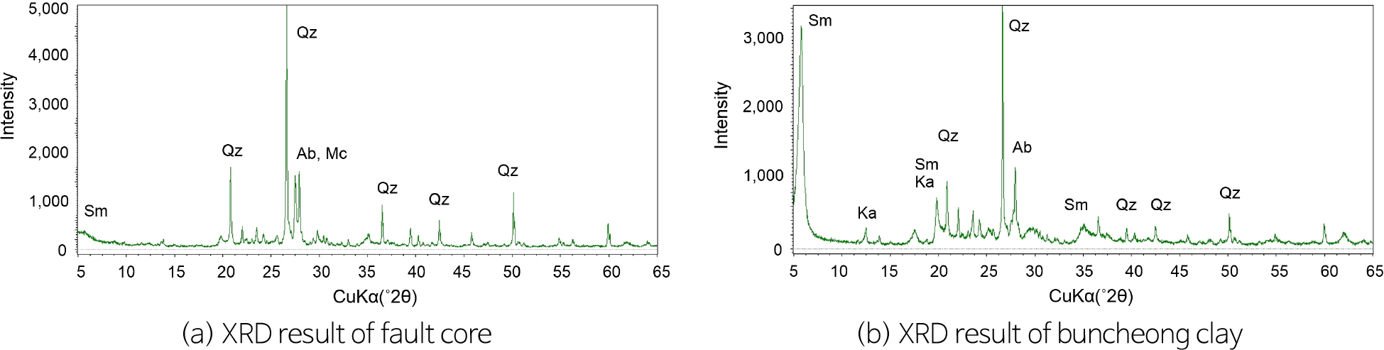
Thixotropic Behavior of Artificial Fault Core Specimens with Buncheong Clay
분청토를 이용한 인공 단층핵 시료의 틱소트로피 거동
-
Yu-Jin Ha, Se-Jeong Ju, Hyeong-Sin Kim, MinJi Kang, Yong-Seok Seo
하유진, 주세정, 김형신, 강민지, 서용석
- Laboratory tests were conducted to investigate the permeability and shear characteristics of artificial fault core samples. Due to the difficulty of preparing …
본 연구에서는 인공 단층핵 시료의 투수특성과 전단특성을 파악하기 위하여 실내시험을 실시하였다. 자연 단층핵 시료의 제작상 어려움 때문에 단층점토 대신 분청토를 이용하여 시료를 …
- Laboratory tests were conducted to investigate the permeability and shear characteristics of artificial fault core samples. Due to the difficulty of preparing natural fault core samples, buncheong clay was used in place of fault gouge to fabricate the test specimens. To assess the development of thixotropy (i.e., the time-dependent physical characteristics of clay specimens), permeability and direct shear tests were carried out at 3, 7, 14, 21, and 28 days after specimen preparation. The results of variable-head permeability tests indicate a substantial decrease in hydraulic conductivity, from 2.98 × 10⁻³ to 5.97 × 10⁻⁶ cm/sec on day 3 to 1.27 × 10⁻⁶ to 5.09 × 10⁻⁷ cm/sec on day 28. In addition, the range of hydraulic conductivity values decreased over time, indicating reduced variability. Direct shear tests showed a gradual increase in the internal friction angle from 23° to 38° over the same period. These hydraulic and mechanical changes are attributed to the development of thixotropy, and it is inferred that the clay particles undergo microstructural rearrangement over time, leading to a more stable structure.
- COLLAPSE
본 연구에서는 인공 단층핵 시료의 투수특성과 전단특성을 파악하기 위하여 실내시험을 실시하였다. 자연 단층핵 시료의 제작상 어려움 때문에 단층점토 대신 분청토를 이용하여 시료를 제작하였다. 점토시료의 물리적 특성인 시간경과에 따른 틱소트로피 현상의 발현을 확인하기 위하여 시료 제작 후 3일, 7일, 14일, 21일, 28일 경과한 후에 실내 투수시험과 직접전단시험을 실시하였다. 실내 투수시험 시 수리전도도는 3일차에 2.98 × 10⁻³ ~ 5.97 × 10⁻⁶ cm/sec, 28일차에 1.27 × 10⁻⁶ ~ 5.09 × 10⁻⁷ cm/sec로 감소하였으며, 시간이 경과함에 따라 수리전도도의 분산 정도가 감소하는 경향을 보였다. 직접전단시험 시 내부마찰각은 3일차에 23°에서 28일 경과 후 38°로 증가하였다. 이러한 수리 ‧ 역학적 변화는 틱소트로피 발현에 기인하며, 시간이 경과함에 따라 점토입자가 재배열되면서 안정된 것으로 판단된다.
-
Thixotropic Behavior of Artificial Fault Core Specimens with Buncheong Clay
-
Research Article
-
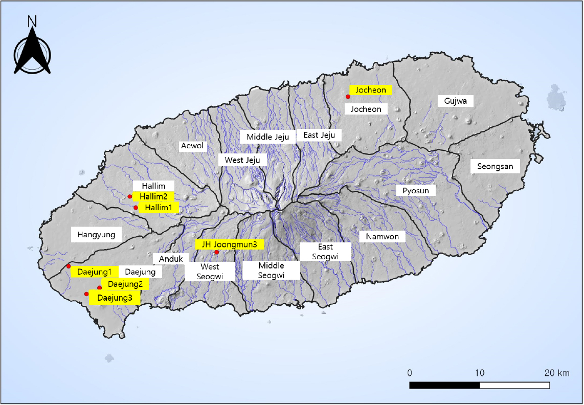
Regression Analysis for Predicting Nitrate-N Concentrations in Groundwater in Western Jeju
제주 서부지역 지하수의 질산성질소 농도 예측을 위한 회귀분석
-
Gyu-Han Kim, Hyeong-Sin Kim, Yong-Seok Seo
김규한, 김형신, 서용석
- This study aims to identify the key controls on nitrate nitrogen (NO3-N) concentrations in groundwater and proposes regression-based models for …
본 연구는 제주도 서부 지역의 지하수 관정 32공을 대상으로 질산성질소(NO3-N) 농도에 영향을 미치는 주요 요인을 분석하고, 예측 가능한 회귀모델을 제시하고자 …
- This study aims to identify the key controls on nitrate nitrogen (NO3-N) concentrations in groundwater and proposes regression-based models for prediction of the concentrations, focusing on 32 wells in western Jeju Island. Conventional groundwater vulnerability indices such as DRASTIC, DRASTIC_jeju, and WELCUP had limited explanatory power for NO3-N concentrations (adjusted R2 < 0.1). In contrast, multiple regression models combining the size of agricultural area and the distance to pollution source (e.g., 1/d, 1/d2) showed significantly higher predictive performance with Adj. R2 values of ~0.49 and statistically significant p-values (p < 0.05). Error analysis using mean absolute error (MAE), root mean square error (RMSE), and relative excess error (REE) showed that some models maintained stable prediction performance even in the presence of outliers (i.e., high-concentrations of NO3-N). These findings suggest that spatial variables play a critical role in explaining the distribution of NO3-N and that the proposed models could be practically used for groundwater pollution management and identifying nitrate-vulnerable zones in groundwater on Jeju Island.
- COLLAPSE
본 연구는 제주도 서부 지역의 지하수 관정 32공을 대상으로 질산성질소(NO3-N) 농도에 영향을 미치는 주요 요인을 분석하고, 예측 가능한 회귀모델을 제시하고자 하였다. 지하수 오염취약성 평가를 위해 DRASTIC, DRASTIC_jeju, WELCUP 지수를 산정하였으나, 이들 지수만으로는 NO3-N 농도의 예측력이 제한적이었으며(adjusted R2 < 0.1), 통계적 유의성도 확보되지 않았다. 반면, 농경지 면적과 점오염원(개인하수처리시설, 축산폐수배출시설)과의 거리 기반 지표(1/d, 1/d2)를 조합한 회귀모델에서는 Adj. R2 ≈ 0.49 수준의 설명력과 p < 0.05의 유의성을 확보하였다. 또한 평균절대오차(mean absolute error, MAE), 평균제곱근오차(root mean square error, RMSE), 상대초과 오차율(relative excess error, REE)을 활용한 예측오차 분석 결과, 일부 모델은 고농도 이상치가 존재하는 경우에도 예측의 안정성을 유지함을 확인하였다. 이러한 결과는 NO3-N 분포를 설명하는 데 있어 공간적 변수가 핵심적인 역할을 하며, 제안된 회귀모델이 제주도 지하수 오염관리 및 오염취약지역 선별을 위한 실용적인 분석 도구로 활용 가능함을 시사한다.
-
Regression Analysis for Predicting Nitrate-N Concentrations in Groundwater in Western Jeju
-
Research Article
-
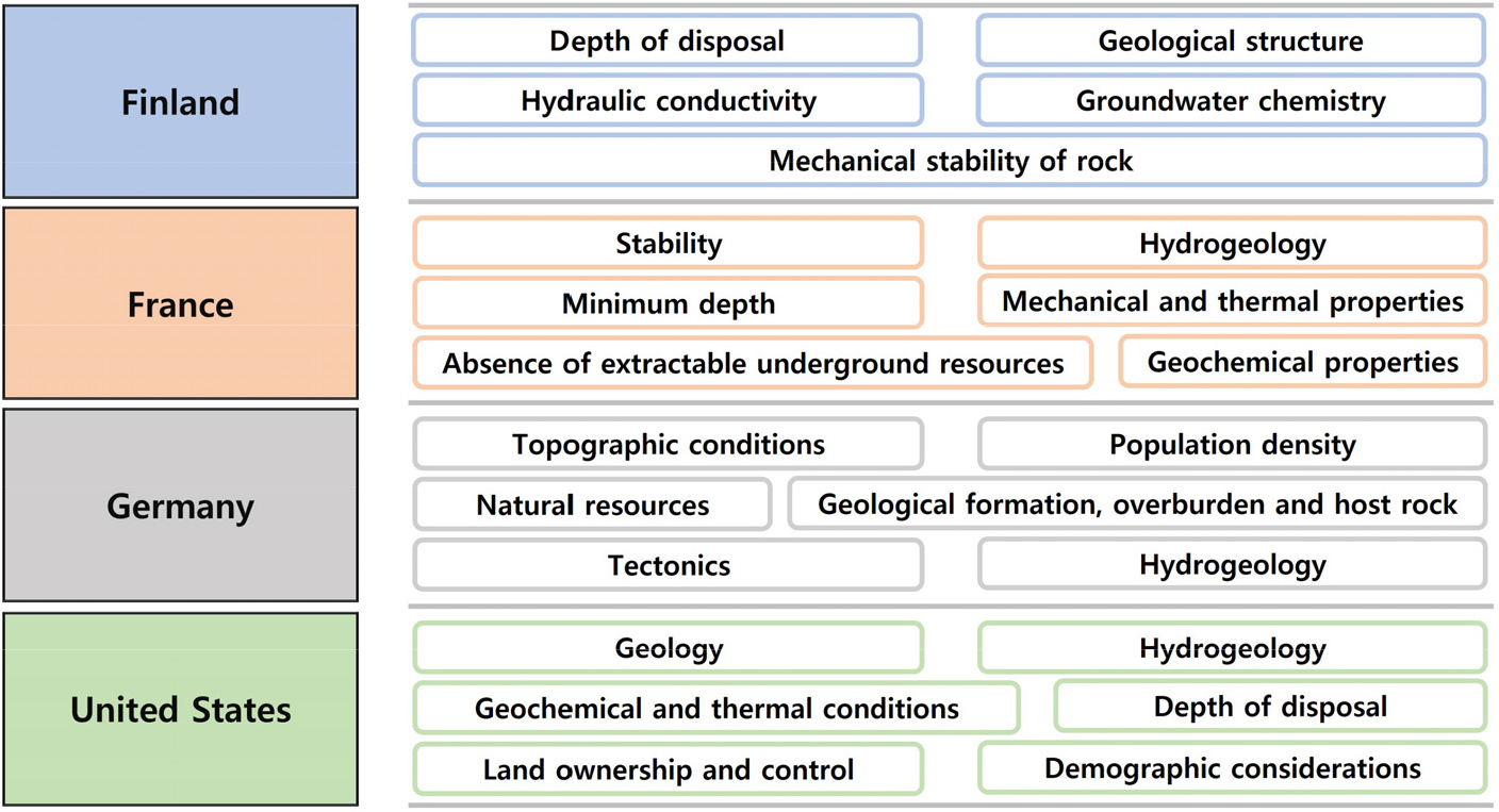
Analysis of International Regulatory Requirements for High-Level Radioactive Waste Disposal Sites and Natural Barriers
고준위방사성폐기물 처분 부지 및 천연방벽 규제 요건에 관한 국제 규제 동향 및 분석
-
Taeyoo Na, Byung-Gon Chae
나태유, 채병곤
- Ensuring the long-term safety of high-level radioactive waste disposal requires securing the geological stability of the disposal site and the long-term performance …
고준위방사성폐기물의 안전한 처분을 위해서는 처분 부지의 지질학적 특성과 천연방벽 성능의 장기 안전성을 확보할 수 있어야 하며, 이를 평가하고 기술 수준 확보를 위한 …
- Ensuring the long-term safety of high-level radioactive waste disposal requires securing the geological stability of the disposal site and the long-term performance of natural barriers. To achieve this, clear regulatory guidelines and requirements are essential for evaluating site suitability and establishing the necessary technical standards. This study considers the regulatory requirements and guidelines related to candidate disposal sites and natural barriers established by authorities in Sweden, Finland, France, Germany, and the United States, and compares them with the current regulatory framework in Korea. The analysis revealed that these countries have developed specific and quantitative criteria for key factors affecting long-term safety, such as geological stability, hydrogeological conditions, the geochemical environment, disposal depth, and the presence of natural resources. In particular, their approaches to natural barriers involve a comprehensive evaluation of radionuclide retardation and groundwater chemistry. In contrast, the current guidelines in Korea remain largely qualitative, highlighting the need for improvements in the specificity of regulatory criteria. Based on this comparative analysis, this study offers guidance for establishing a more-robust site selection process and regulatory system in Korea and provides a foundation for developing performance requirements and regulatory guidelines that are suitable for the country’s geological conditions.
- COLLAPSE
고준위방사성폐기물의 안전한 처분을 위해서는 처분 부지의 지질학적 특성과 천연방벽 성능의 장기 안전성을 확보할 수 있어야 하며, 이를 평가하고 기술 수준 확보를 위한 명확한 규제 지침 및 요건이 필요하다. 본 연구에서는 해외 처분 선도국인 스웨덴, 핀란드, 프랑스, 독일, 미국의 규제기관이 설정한 처분 후보 부지 및 천연방벽 관련 규제 요건과 지침을 분석하고, 이를 국내 규제 요건과 비교분석하였다. 분석 결과, 선도국들은 지질학적 안정성, 수리지질학적 조건, 지구화학적 환경, 처분 깊이, 천연자원 존재 여부 등 장기 안전성에 영향을 미치는 요소별로 정량적이고 구체적인 기준을 제시하고 있었다. 특히, 천연방벽에 대해서는 핵종 이동 지연, 지하수 화학 조건 등을 종합적으로 고려하고 있었다. 반면, 국내의 경우 현재 정성적 형태로 제시되고 있어 기준 및 지침의 구체성 보완이 필요한 것으로 나타났다. 본 연구는 이러한 비교분석 결과를 바탕으로, 국내 처분 부지선정 및 규제체계 정립에 필요한 시사점을 도출하고, 향후 우리나라 지질환경에 적합한 성능 요건과 규제지침 마련에 필요한 기초자료를 제공하는 데 그 의의가 있다.
-
Analysis of International Regulatory Requirements for High-Level Radioactive Waste Disposal Sites and Natural Barriers
-
Research Article
-
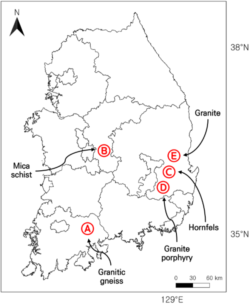
Development of Evaluation Indices for Dam-Foundation Grouting Based on Correlation Analysis between Discontinuity and Hydrogeological Parameters across Rock Types
암종별 불연속면 ‧ 수리지질 인자의 상관분석을 통한 댐 기초 그라우팅 평가 지표 제안
-
Kwangmin Beck, Hyerim Lee, Minjune Yang
백광민, 이혜림, 양민준
- To successfully perform rock grouting and ensure the safety of a dam, it is important to choose appropriate evaluation factors and select …
댐 구조물의 안전성 확보를 위해 시행되는 암반그라우팅의 성공적인 수행을 위해서는 국내 지질환경에 적합한 평가 인자의 합리적인 선정 및 계획 수립이 중요하다. 본 …
- To successfully perform rock grouting and ensure the safety of a dam, it is important to choose appropriate evaluation factors and select grout that is suitable for the local geological environment. We used data from rock types at five dam sites (A-E) to analyze the correlation between discontinuity characteristics [rock quality designation (RQD) and joint spacing (Js)] and hydrogeological factors [Lugeon value (Lu) and secondary permeability index (SPI)], which are key evaluation factors for rock grouting. Sites A and D, which are composed of granitic gneiss and granitic porphyry that is >60% fair-poor quality, showed decreasing correlation from RQD versus Lu (Site A: r = -0.86; Site D: r = -0.65) to RQD versus SPI (Site A: r = -0.80; Site D: r = -0.64), Js versus Lu (Site A: r = -0.59; Site D: r = -0.38), and finally Js versus SPI (Site A: r = -0.54; Site D: r = -0.36). Sites B and C, which consist of >70% good quality mica schist and hornfels, also showed decreasing correlation from RQD versus Lu (Site B: r = -0.89; Site C: r = -0.74) to RQD versus SPI (Site B: r = -0.81; Site C: r = -0.66), Js versus Lu (Site B: r = -0.48; Site C: r = -0.34), and finally Js versus SPI (Site B: r = -0.50; Site C: r = -0.30). Site E (granite), which contains >70% moderate-good quality rock, showed decreasing correlation from RQD versus Lu (r = -0.70) to RQD versus SPI (r = -0.67), Js versus Lu (r = -0.50), and finally Js versus SPI (r = -0.44), although caution is required in interpreting these results due to the limited data. Based our results, RQD and SPI are key factors for classifying the rock quality of dam foundations and planning grouting works, and are closely correlated. The evaluation indicators (RQD and SPI) and the hydrogeological approach presented here are applicable in practice, and the correlation of each factor may serve as useful basic data for future research.
- COLLAPSE
댐 구조물의 안전성 확보를 위해 시행되는 암반그라우팅의 성공적인 수행을 위해서는 국내 지질환경에 적합한 평가 인자의 합리적인 선정 및 계획 수립이 중요하다. 본 연구에서는 국내 5개 댐 부지(A-E)에 분포하는 암종을 대상으로, 암반그라우팅과 밀접한 관련이 있는 불연속면 특성 인자(RQD, Js)와 수리지질학적 인자(Lu, SPI) 간의 상관관계를 분석하였다. 보통-불량한 암질이 60% 이상 분포하는 A 부지(화강암질 편마암)와 D 부지(화강반암)에서는 RQD-Lu(A 부지: r = -0.86; D 부지: r = -0.65), RQD-SPI(A 부지: r = -0.80; D 부지: r = -0.64), Js-Lu(A 부지: r = -0.59; D 부지: r = -0.38), Js-SPI(A 부지: r = -0.54; D 부지: r = -0.36) 순으로 상관성이 감소하였다. 양호한 암질이 70% 이상 분포하는 B 부지(운모 편암)와 C 부지(혼펠스) 역시 RQD-Lu(B 부지: r = -0.89; C 부지: r = -0.74), RQD-SPI(B 부지: r = -0.81; C 부지: r = -0.66), Js-Lu(B 부지: r = -0.48; C 부지: r = -0.34), Js-SPI(B 부지: r = -0.50; C 부지: r = -0.30) 순으로 상관성이 감소하는 경향을 보였다. 보통-양호한 암질이 70% 이상 분포하는 E 부지(화강암)에서는 RQD-Lu(r = -0.70), RQD-SPI(r = -0.67), Js-Lu(r = -0.50), Js-SPI(r = -0.44)순으로 음의 상관성이 나타났으며, 자료 수의 제한으로 해석에 주의가 필요하다. 이러한 분석 결과를 바탕으로, RQD와 SPI는 댐 기초 지반의 암질을 정량적으로 평가하고 그라우팅 계획을 수립하는 데 유의한 상관성을 나타내는 핵심 인자로 확인되었다. 본 연구에서 제시한 평가 인자(RQD, SPI) 및 수리지질학적 접근법은 향후 암반그라우팅 실무 적용에 있어 유용하게 활용될 수 있으며, 도출된 인자 간 상관성 분석 결과는 후속 연구를 위한 유용한 기초 자료로 활용될 수 있을 것으로 기대된다.
-
Development of Evaluation Indices for Dam-Foundation Grouting Based on Correlation Analysis between Discontinuity and Hydrogeological Parameters across Rock Types
-
Research Article
-
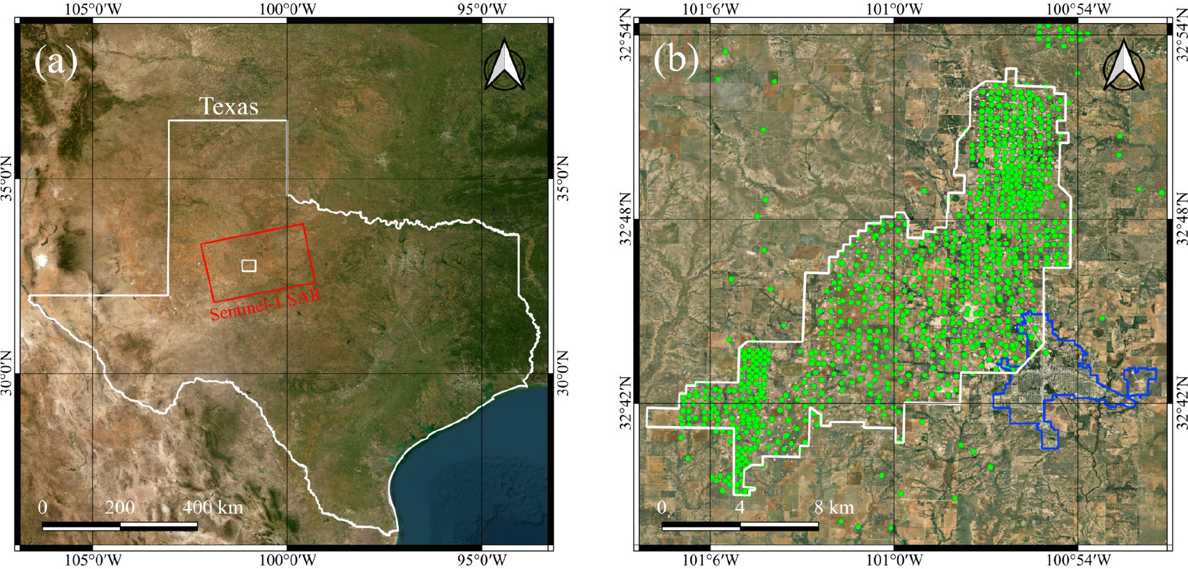
Analysis of Surface Displacement Time-Series Obtained in the SACROC Oil Field during CO2-EOR Using PSInSAR
PSInSAR를 이용한 CO2-EOR이 적용된 SACROC 유전의 시계열 지표변위 분석
-
Junbeom Park, Hyangsun Han, Taewook Kim
박준범, 한향선, 김태욱
- Carbon dioxide-enhanced oil recovery (CO2-EOR) is a promising carbon capture and storage (CCS) technique that can simultaneously improve oil productivity …
이산화탄소 주입을 통한 원유 회수 증진(carbon dioxide-enhanced oil recovery, CO2-EOR)은 원유 생산성과 온실가스 감축을 동시에 달성할 수 있는 유망한 탄소 …
- Carbon dioxide-enhanced oil recovery (CO2-EOR) is a promising carbon capture and storage (CCS) technique that can simultaneously improve oil productivity and reduce greenhouse gas emissions. However, large-scale injection of CO2 into subsurface reservoirs during CO2-EOR can induce surface displacement, potentially affecting the stability of CCS operations and surface infrastructure; therefore, precise monitoring of surface displacement in oil fields where CO2-EOR is used is essential. We applied persistent scatterer interferometric synthetic aperture radar (PSInSAR), a time-series InSAR technique, to Sentinel-1 SAR data acquired from October 2016 to June 2024 to monitor surface displacement and investigate the cause of displacement at the Snyder Area Canyon Reef Operating Committee (SACROC) oil field in Texas, United States, where CO2-EOR is being implemented. In the northern and northeastern parts of the oil field, localized uplift with line of sight (LOS) displacement velocities of up to 4.9 mm/yr and subsidence of up to 4.7 mm/yr in LOS were observed. These displacement velocities are likely due to imbalances between CO2 injection and oil extraction. In the central region of the oil field, the LOS displacement velocities remained less than ±1 mm/yr, suggesting a relative equilibrium between CO2 injection and oil extraction. In the nearby city of Snyder, minimal LOS displacement velocities (less than ±0.5 mm/yr) were observed, indicating stable ground conditions. This study demonstrates that PSInSAR can be used to effectively assess the stability and optimize the CCS operatons involving CO2-EOR.
- COLLAPSE
이산화탄소 주입을 통한 원유 회수 증진(carbon dioxide-enhanced oil recovery, CO2-EOR)은 원유 생산성과 온실가스 감축을 동시에 달성할 수 있는 유망한 탄소 포집 및 저장(carbon capture and storage, CCS) 기술로 각광받고 있다. CO2-EOR을 적용할 때, 이산화탄소를 저류층에 대량 주입할 경우 지표 변형이 유발될 수 있으며, 이는 CCS의 안정성뿐만 아니라 지상의 다양한 인프라에도 위험을 초래할 수 있다. 따라서 CO2-EOR이 적용된 유전 지역의 정밀한 지표변위 모니터링이 필수적이다. 이 연구에서는 CO2-EOR 방식으로 원유를 생산하는 미국 텍사스 주의 Snyder Area Canyon Reef Operating Committee(SACROC) 유전을 대상으로 2016년 10월부터 2024년 6월까지 획득된 Sentinel-1 합성구경레이더(synthetic aperture radar, SAR) 자료에 시계열 레이더 간섭기법 중 하나인 고정산란체 간섭기법(persistent scatterer interferometric SAR, PSInSAR)을 적용하여 레이더 관측 방향(line of sight, LOS)의 지표변위를 관측하고, 변위의 발생 기작을 해석하였다. 유전의 북부 및 북동부 지역에서는 이산화탄소의 주입 및 원유 생산의 상대적 불균형에 기인하는 것으로 추정되는 국지적인 지표변위가 관측되었으며, 레이더 관측 방향에서 최대 4.9 mm/yr의 지반 융기와 최대 4.7 mm/yr의 침하가 확인되었다. 유전의 중부 지역에서는 LOS 변위속도가 ±1 mm/yr 이내로 작았으며, 이산화탄소 주입과 원유 생산에 의한 지표변위의 평형이 상대적으로 유지되고 있음을 추정할 수 있었다. 유전에 인접한 도시인 Snyder에서는 ±0.5 mm/yr 이내의 매우 작은 LOS 변위속도가 관측되어 지반이 안정적임을 확인하였다. 이 연구는 이산화탄소 주입과 원유 생산이 병행되는 지역에서 PSInSAR 기법이 CCS의 안정성 평가와 운영 최적화에 효율적으로 활용될 수 있음을 보여주었다.
-
Analysis of Surface Displacement Time-Series Obtained in the SACROC Oil Field during CO2-EOR Using PSInSAR

Journal Informaiton
 The Journal of Engineering Geology
The Journal of Engineering Geology


대한지질공학회
Room 4311, Daejeon Universtiy, 62 Daehak-ro, Dong-gu, Daejeon 34520, Korea
Tel: +82-42-280-2737 / Fax: +82-42-280-4575 / E-mail: parkyc@kangwon.ac.kr Copyright© Korean Society of Engineering Geology. Powered by APUB
Tel: +82-42-280-2737 / Fax: +82-42-280-4575 / E-mail: parkyc@kangwon.ac.kr Copyright© Korean Society of Engineering Geology. Powered by APUB