Technical Note

The Journal of Engineering Geology. 30 June 2023. 335-353
https://doi.org/10.9720/kseg.2023.2.335

ABSTRACT


MAIN

  • 서 론

  • 부지선정 방식

  •   미국

  •   스웨덴

  •   스위스

  •   독일

  •   영국

  • 부지선정 방식 비교

  • 토의 및 결론

서 론

우리나라는 고준위방사성폐기물 관리정책의 원칙과 로드맵, 추진과제 등을 위해 「방사성폐기물 관리법」 제6조에 따라 제2차 고준위방사성폐기물 관리 기본계획을 발표하였으며(MOTIE, 2021), 이를 토대로 고준위방사성폐기물의 처분을 위한 준비를 하고 있다. 해외 처분 선도국의 경우 고준위방사성폐기물의 관리를 위한 부지선정을 위해 단계별 부지선정 기준과 지침을 수립하였다. 본 논문에서는 스위스, 스웨덴, 독일 등 처분 선도국들의 처분시설 부지선정 과정과 각 단계에서의 선별 방법을 알아보고자 한다.

부지선정 방식

미국

미국은 1982년에 방사성폐기물정책법(Nuclear Waste Policy Act, NWPA)을 제정하여 연방정부가 고준위방사성폐기물 처분을 책임지도록 규정하였고, 해당 법에 따라 부지선정 등 관련 업무는 DOE(Department Of Energy)의 산하기관인 OCRWM(Office of Civilian Radioactive Waste Management)이 담당하게 되었다(ORNL, 1996). Fig. 1은 미국의 고준위방사성폐기물 처분 부지선정 과정을 나타낸다(Philip, 2005).

미국의 부지선정 절차는 10 CFR Part 960 방사성폐기물 저장소를 위한 잠재부지의 예비 스크리닝을 위한 일반 지침에 기재되어 있으며, 크게 2단계로 구분되고, 두 번째 단계는 5개의 세부 단계로 구분된다(DOE, 1984).

• 1단계: 잠재적으로 허용가능한 부지(Potentially Acceptable Sites, PASs) 선정(미국 전역 → 9개 지역)

• 2단계: 특성화에 적합한 부지선정

2-1단계: 모든 잠재적으로 허용가능한 부지의 평가

2-2단계: 수문지질단위 내 부지 선택(9개 지역 → 5개 지역)

2-3단계: 지명을 위해 제안된 모든 부지의 비교 평가

2-4단계: 환경영향평가(5개 지역 → 3개 지역)

2-5단계: 공식 부지 지명(3개 지역 → 1개 지역)

1단계에서 DOE는 NWPA의 116(a) 항에 따라 1983년 2월에 9개의 PASs를 선정했다. 해당 9개의 부지는 1970년대 후반에 수행된 NWTS(National Waste Terminal Storage) 등 기존의 연구 결과를 바탕으로 선정되었으며 각 부지의 선정 조건은 수문지질단위에 따라 상이하다(Table 1)(ORNL, 1996).
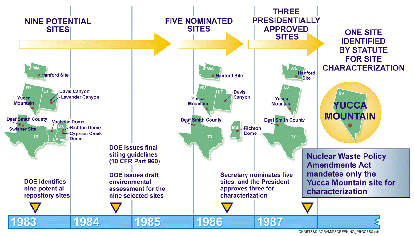
https://static.apub.kr/journalsite/sites/kseg/2023-033-02/N0520330208/images/kseg_2023_332_335_F1.jpg
Fig. 1.

Site selection process in the USA (Philip, 2005). DOE = Department of the Environment.

Table 1.

PASs (potentially acceptable sites) criteria and selected sites in the USA (ORNL, 1996)

Rock type Criteria PASs selected sites
Salt dome - Depth of salt
- Lateral extent cross-sectional (area) of salt mass at repository depths
- Existing competing uses, led the GPM (Geologic Project Manager) firm to
recommend 11 domes (Vacherie, Rayburn’s, Goochie Brake, Richton,
Lampton, Cypress Creek, Boggy Creek, Keechi, Mount Sylvan, Oakwood,
Palestine) as potentially acceptable
• Louisiana Vacherie dome
• Mississippi Cypress Creek dome
• Mississippi Richton dome
Bedded salt - Depth and thickness of salt
- Mapped faults
- Other evidence of recent geologic instability
- Zones of groundwater discharge
- Significant resources
- Potential for flooding proximity to urban areas
- Presence of certain dedicated lands
• Utah Davis Canyon
• Utah Lavender Canyon
• Texas Deaf Smith County
• Texas Swisher County
Basalt flows - Geologic circumstances
- Hydrologic circumstances
- Environmental circumstances
- Ecological circumstances
• Washington Hanford Site, RRL
(reference repository location)
Welded tuff - Existence of a relatively undisturbed structural block
- Presence of a thick sequence of volcanic tuff, much of it rich in adsorptive
zeolite minerals.
• Nevada Yucca Mountain

이후 2단계에서는 10 CFR Part 960의 3-1. Siting provisions에 따라 수문지질단위를 구분하고 특성화를 위한 후보부지 추천에 환경영향평가를 포함하거나 참조된 자료를 사용해야 한다. 이를 위해 2-1단계에서 1984년 12월 발표된 환경영향평가(안)(Draft Environmental Assessment)를 진행하였고 이를 바탕으로 2-2단계에서 9개의 PASs를 수문지질단위에 따라 5개의 그룹으로 나누어 각 그룹에서 하나씩 후보부지를 선택했다(Table 2)(ORNL, 1996). 그 후 2-3단계에서 환경영향평가(Environmental Assessment, EA)를 수행하였고 해당 자료를 바탕으로 2-4단계에서 다속성 효용이론(Multiattribute Utility Analysis)을 통해 특성화 후보부지 3곳을 선정하였다. 최종적으로 선정된 3개의 특성화 후보부지는 네바다주의 Yucca Mountain, 텍사스주의 Deaf Smith County, 워싱턴주 Hanford Site의 RRL이었으며 2-5단계에서 미국 의회는 이 중 네바다주의 Yucca Mountain을 최종 처분부지로 선정하였으나(ORNL, 1996) Yucca Mountain이 속해있는 네바다주의 주지사와 환경단체의 반대로 중단이 된 상태이다(WNWR, 2019). 이후 DOE의 자문위원회인 블루리본위원회(Blue Ribbon Committee)에서 ‘동의 기반 부지선정(consent-based siting)’방식을 권고하였고, 현재 미국은 고준위방사성폐기물을 관리하기 위한 새로운 조직 설립, 부지확보를 위한 프로세스, 관리를 위한 자금에 대한 내용을 담은 법안(Nuclear Waste Administration Act of 2019)을 발의했다(CONGRESS.GOV, 2019).

Table 2.

DOE nomination of five sites in the USA (ORNL, 1996)

Geohydrologic
classification
Criteria Selected site
Gulf Coastal Plain
(Salt dome)
- The significantly larger size of the Richton Dome allows significant
flexibility in the location and design of the underground facility so as
to ensure waste isolation.
- There is limited potential for flooding of the dome area.
• Mississippi Richton dome
Permian Basin
(Bedded salt)
- A downward or predominately horizontal groundwater gradient is
present and it is further from highly populated areas than the Swisher
County site.
• Texas Deaf Smith County
Paradox Basin
(Bedded salt)
- In Lavender Canyon, an area under review for possible inclusion in the
National Wilderness System.
• Utah Davis Canyon
Columbia Plateau
(Basalt flows)
- The only potentially acceptable site identified in the Columbia Plateau. • Washington Hanford Site, RRL
Great Basin
(Welded tuff)
- The only potentially acceptable site identified in the Great Basin. • Nevada Yucca Mountain

스웨덴

스웨덴 방사성폐기물 관리기관인 SKB(Svensk Kärnbränslehantering Aktiebolag)는 원자력 활동법, 방사성 방호법에 따른 환경 법규 및 규정의 요구사항을 기반으로 부지선정을 한다. Fig. 2는 스웨덴의 심층처분시설 부지선정을 위한 각 단계를 나타낸다(SKB, 2000).

https://static.apub.kr/journalsite/sites/kseg/2023-033-02/N0520330208/images/kseg_2023_332_335_F2.jpg
Fig. 2.

Swedish site selection process (SKB, 2000).

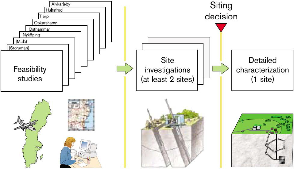
스웨덴의 심층처분시설 부지선정 과정은 크게 3단계로 구성되어있다. 1단계는 일반적인 부지조사 단계로서 전국 규모의 기존자료조사를 수행하고, 2단계는 타당성 조사(Feasibility studies, FS)로 여러 지역사회가 타당성 조사에 참여하며, 지방자치단체 범위에서 심층처분시설 건설 가능성을 검토한다. 3단계는 다시 두 단계로 나뉘며 첫 번째는 부지특성조사 단계로서 선정된 부지에 심층처분시설 건설 가능 여부를 판단할 수 있는 자료확보를 위해 시추조사, 안전성 평가, 환경영향평가 등을 수행하는 초기 조사(Initial site investigation, ISI) 단계, 두 번째는 상세 조사 단계로 결정된 심층처분시설 부지에 대한 상세 부지조사(Complete site investigation, CSI)단계이다. 초기 조사에서 수행되는 환경영향평가는 이 부지선정 과정에 의해 가장 크게 영향을 받는 지역 주민들과의 협의에 따라 진행된다(SKB, 2000).

• 1단계 - 일반적인 부지조사: 스웨덴 전역을 대상으로 부지 적합성을 판단하는 부지선정 과정과 관련될 수 있는 기존자료에 대한 지역별 또는 전국적인 분석(스웨덴 전역 → 8개 지역)

• 2단계 - 타당성 조사(FS): 지방자치단체 규모의 분석이며 기반암 정보, 토지 이용 현황, 환경적인 영향, 운송 전망 및 사회적 조건들에 대한 자료를 제공하고 추가조사를 위한 관심 영역을 도출함, 8개 지역에서 수행됨(8개 지역 → 2개 지역)

• 3단계 - 부지조사: 지표면과 시추공 내 기반암에 대한 포괄적인 조사, 암석의 특성과 관련하여 심부처분시설에 대한 부지의 적합성을 분석하고 평가하는 데 이용하며 2개 지역에서 상세 조사(초기 조사(ISI), 상세 부지조사(CSI))를 수행하였음(2개 지역 → 1개 지역)

부지선정을 위한 배제 인자는 크게 지형, 토양층, 암종, 구조지질, 역학적 안전성, 열적 특성, 지질학적 사건의 7개 항목이며, 상세한 내용은 Table 3과 같다(SKB, 1995). 스웨덴은 2009년 Forsmark로 최종부지를 선정하였고(SKB, 2011, 2020), 2022년에 건설 승인되었다(SKB, 2022).

Table 3.

Swedish site selection criteria (SKB, 1995)

LONG-TERM RADIOLOGICAL SAFETY
ISOLATION
Chemically stable environment
• low content of foreign material
• low content of corrosion agents
• non-abnormal salt content
• non-abnormal pH
• stable groundwater chemistry with low
groundwater flow
• low gradient
• low transmissivity with mechanical
stability
• low deviator stress
• no large deformations over canister hole
• safe distance
RETARDATION
Chemically stable environment
• low fuel dissolution
• stable buffer
• sorption, matrix diffusion, diffusion
• non-abnormal salt contents
• non-abnormal pH
• stable groundwater chemistry with
low groundwater flow
• low gradient
• low transmissivity
• thermal convection
• density differences
• two-phase flows with mechanical stability
• stable stress field
DISCHARGE AREA dilution
• dispersion
• mixing conditions
• flow stretch
Wells
Biosphere
Coast, sea, inland
Intrusion
• prospecting for ore,
industrial minerals, groundwater
• infrastructure project
TECHNOLOGY
TRANSPORTATION
Existing facilities
INDUSTRIAL AREAS
Geotechnology
• flat land
• land with good load-bearing capacity
UNDERGROUND FACILITY
Low groundwater flow
• low transmissivity with mechanical stability
• low deviator stresses
• high mechanical rock strength
• few fracture zones
Rock investigations
• homogeneous bedrock
• thin soil cover
Repository layout
• tunnel/shaft
• depth
• safe distance to zones
• thermal conductivity
• plugs
• interaction between barriers
Rock engineering
• few crushed sections
• low hydraulic conductivity
• rock conducive to grouting
• low transmissivity
• mechanically stable
• low radon content
Operation
• radon
• canister handling
• non-aggressive water
LAND AND ENVIRONMENT
LEGALLY PROTECTED AREAS
• national parks
• nature reserves
• nature conservation areas
• areas of national interest
• other areas
MANAGEMENT OF NATURAL RESOURCES
• special management regulations with
geographical guidelines
• land and water
• landscape, natural, and cultural environments
• agricultural and forestry, hunting, fishing, and
reindeer husbandry
• outdoor activities and tourism
• natural resources
• land for community development
REPOSITORY DESIGN
Transportation
• existing facilities
Industrial area
• adaption to local conditions
• design of buildings
Underground facility
• groundwater table lowering
• borehole installations
• discharge area
• long-term measurements
Waste rock reclamation area
• availability
SOCIETY
ADMINISTRATIVE BOUNDARIES
POPULATION AND
PROPERTY DEVELOPMENT
LOCAL ECONOMY AND LABOUR MARKET
INFRASTRUCTURE
MUNICIPAL SERVICES AND
ECONOMY
HEALTH
ACCEPTANCE

스위스

스위스의 부지선정은 원자력 활동법과 방사성 방호법에 따른 환경 법규 및 규정의 요구사항을 기반으로 한다. 심층처분시설을 위한 부지선정의 절차와 기준은 2008년 연방의회가 승인한 “심층처분시설에 대한 부문 계획(Sachplan geologische Tiefenlager, SGT)”의 개념 부분을 따른다(SFOE, 2008). 스위스 원자력법에 관한 정부 판결은 새로운 원자력 발전소 건설의 전제 조건으로 스위스에서 방사성폐기물의 안전한 처분이 가능함을 입증하기 위해 매우 구체적인 다음과 같은 요구사항을 설정했다(SFOE, 2008).

• 공학적 타당성, 즉 기존 기술로 설계할 수 있는 개념

• 인간과 환경에 대한 장기적 안전

• 현장 타당성, 즉 위의 두 항이 충족될 수 있는 지층과 위치가 스위스에 존재할 것

이러한 요구사항에 따라 스위스 방사성폐기물 관리기관인 Nagra(Swiss National Co-operative for the Disposal of Radioactive Waste)는 스위스의 방사성폐기물 관리 프로그램을 시작했으며, 여기에는 부지 특성화를 위한 현장 조사와 기본 데이터 세트 및 방법론 개발을 위한 R&D 프로그램 설정이 포함되었다.

Fig. 3에 표시된 부문별 계획은 3단계로 진행되는데 SGT에 수록된 1단계 지질학적 부지선정 배제조건 13개 기준을 통해 전국 규모에서 6개 지역으로 후보부지를 선정하였으며, 2단계 배제조건인 SGT 12개 기준을 통해 6개 지역에서 3개 지역으로 좁혔다. 1단계와 2단계 배제조건은 Tables 4, 5와 같다. 1단계가 안전 및 공학적 타당성에 중점을 둔 반면 2단계는 공간 계획 및 사회경제적 측면도 고려된다. 이 단계에서 영향을 받는 지역사회의 지역 회의(regional conferences)가 개최된다. 지역 회의는 SFOE의 주도하에 연방 당국, 규제기관 및 Nagra와의 상호작용으로 의사결정이 이루어진다(Fig. 4)(SFOE, 2008).
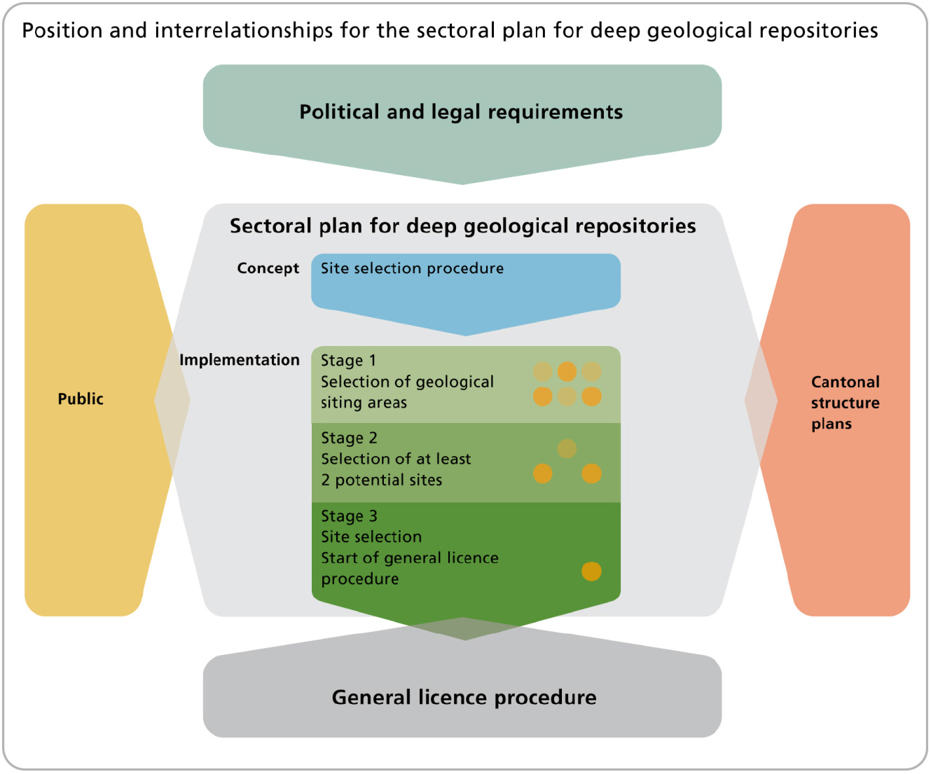
https://static.apub.kr/journalsite/sites/kseg/2023-033-02/N0520330208/images/kseg_2023_332_335_F3.jpg
Fig. 3.

Switzerland site selection process (SFOE, 2008).

Table 4.

Stage 1: Criteria for site evaluation for safety and engineering feasibility, as defined in the sectoral plan of Switzerland (SFOE, 2008)

Criteria group Criteria
Properties of the host rock and of the formations
contributing to the waste isolation
- Spatial extent
- Hydraulic barrier effectiveness
- Geochemical conditions
- Release pathways
Long-term stability - Geologic/tectonic stability
- Erosion
- Repository-induced effects
- Resource conflicts
Reliability of geological database and statements - Ability to characterize formations
- Explorability of spatial conditions
- Predictability of long-term changes
Engineering suitability - Geomechanical properties and conditions
- Underground access and management of inflowing water
Table 5.

Stage 2: Objectives and respective criteria for the selection of potential areas for surface facilities in Switzerland (SFOE, 2008)

Objective Criteria
Safety and engineering feasibility - Location, surrounding area
- Access to the underground
- Safety
Spatial/environmental impact - Planning law requirements
- Surface waters
- Groundwater
- Mineral and thermal waters
- Nature and landscape protection
Local integration into the region - Present-day use
- Embedding in urban development and landscape
- Recreation
- Overdevelopment
- Landscape/natural scenery

https://static.apub.kr/journalsite/sites/kseg/2023-033-02/N0520330208/images/kseg_2023_332_335_F4.jpg
Fig. 4.

Siting stages in Switzerland (SFOE, 2008).

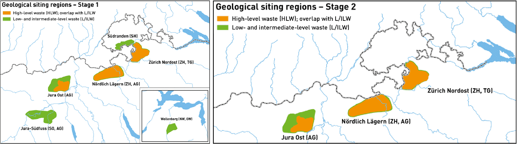
3단계에서는 인허가 신청을 위해 2단계 결과인 3개 후보부지에 대해 보다 상세한 조사를 실시하며 필요한 경우 추가 지질조사를 수행하고, 지역 협의체와 협력하여 처분시설에 대한 사회경제적 측면을 면밀히 조사한다(SFOE, 2008). Nagra는 지질조사 결과와 3개 후보부지의 안전 관련 비교 검토를 바탕으로 3단계 과정을 통해 최종 1개의 부지로 Nördlich Lägern을 선정하였다(SFOE, 2008; SFOE, 2022).

독일

독일의 부지선정 절차는 2017년 부지선정법(Standortauswahlgesetz, StandAG)에 따라 독일의 방사성폐기물 관리기관인 BGE(Bundesgesellschaft für Endlagerung mbH)에 의해 수행되고, 부지선정법은 처분을 위한 시설의 부지선정부터 투명한 조사를 위해 과학적이며 개방적인 절차를 규제한다(BGE, 2020). 부지선정 절차는 3단계로 진행된다(Fig. 5).

https://static.apub.kr/journalsite/sites/kseg/2023-033-02/N0520330208/images/kseg_2023_332_335_F5.jpg
Fig. 5.

Siting stages in Germany (BGE, 2020).

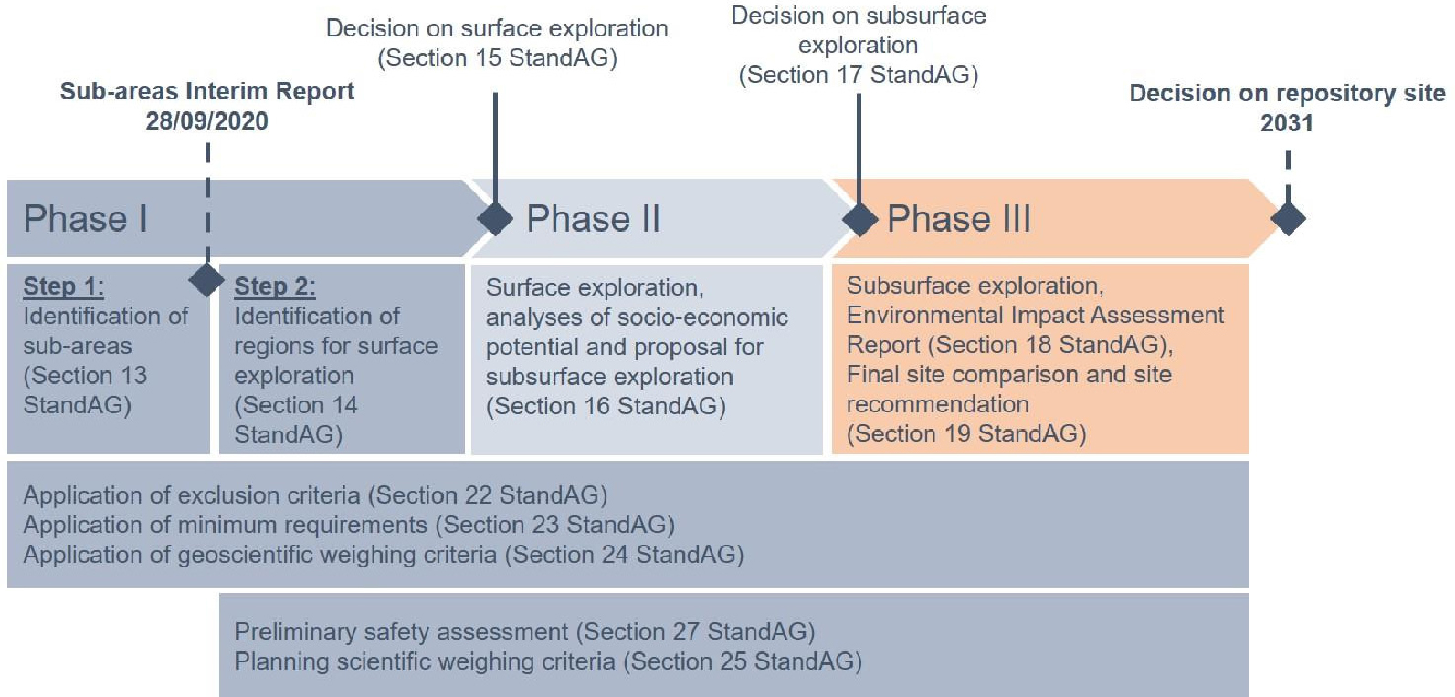
• Phase Ⅰ: 지표조사를 위한 후보부지 결정

Phase Ⅰ - Step 1: 후보부지 식별

Phase Ⅰ - Step 2: 지표조사를 위한 후보부지 식별

• Phase Ⅱ: 지표조사 진행 및 심부환경조사를 위한 후보부지 결정

• Phase Ⅲ: 심부환경조사 진행 및 심층처분시설 부지 결정

부지선정법 제22조 배제조건, 제23조 최소요구조건, 제24조 지구과학적 가중치 요건은 부지선정 3단계 전반에 걸쳐 적용되며, 제27조 예비 안정성 평가와 제25조 과학적 가중치 기준 계획은 Phase Ⅰ - Step 2부터 Phase Ⅲ까지 적용된다. Table 6은 부지선정법 제22조 배제조건, Table 7은 제23조 최소요구조건, Table 8은 제24조 지구과학적 가중치 요건에 대한 상세 내용이다(BGE, 2020).

Table 6.

Exclusion criteria in Germany based on Section 22 StandAG (Standortauswahlgesetz) (BGE, 2020)

Exclusion criteria Applied working method
Large-scale vertical
movements
- An area is no longer suitable as a repository site if average large-scale geogenic uplift of >1 mm yr-1
is expected over a period of 1 Myr.
Active fault zones - An area is not suitable as a repository site if geologically active fault zones may affect the repository
system and its barriers are present in rock areas considered as repository zones, including an
adequate buffer zone.
Influences from current or
past mining activities
- An exclusion must apply if the rock mass has been damaged by current or previous mining activities
in such a way that negative impacts on the stress state and permeability of the rock mass in the area
of a designated effective containment zone or designated repository zone are expected.
Seismic activity - An area is no longer suitable as a repository site if the local seismic hazard is greater than that in
seismic zone 1 according to DIN EN 1998-1/NA:2011-01.
Volcanic activity - An area is no longer suitable as a repository site if Quaternary volcanism is present or future volcanic
activity is expected over the period of 1 Myr.
Groundwater age - An area is not suitable as a repository site if young groundwater is found in rock areas that may be
taken into consideration as effective containment zones or storage areas.
Table 7.

Minimum requirements in Germany, according to Section 23 StandAG (BGE, 2020)

Minimum requirements Applied working method
Hydraulic conductivity
of the rock
- Evaluation of data basis, transfer of information to the area/space if no local disparity assumed.
- Minimum requirement is deemed satisfied, depending on available data and the absence of
indications that cast doubt on compliance with the minimum requirement for hydraulic
conductivity of the rock.
Thickness of the effective
containment zone
- In 3D models, the thickness results from the difference between the upper and lower boundary,
and the rock formation that is relevant as a repository site or the stratigraphic unit. Alternatively,
the information may originate from thickness maps.
- In this regard, the upper and lower boundaries are formed by the natural layer boundary and/or by
restrictions on the depth of the effective containment zone according to the minimum requirement
pursuant to Section 23 para. 5 No. 3 StandAG and the maximum search depth of 1,500 m.
Minimum depth of the
effective containment zone
- Ground surface minus 300 m.
- In the case of rock salt in a steep deposit, the minimum requirement is taken into account by
projecting the salt dome surface 300 m downward.
Surface of the repository - Maximum expanse of the coherent distribution of areas created by 2D or 3D processing for the
respective rock formation with relevance for a repository site.
Preservation of the
barrier effect
- Where there is clear evidence or data that the preservation of the barrier effect appear is doubtful,
the minimum requirement is considered not to have been satisfied.
Table 8.

Geoscientific weighting criteria in Germany, pursuant to Section 24 StandAG (BGE, 2020)

Geoscientific weighting criteria
Criterion 1 Evaluation of the transport of radioactive substances by groundwater movements in the effective containment zone
Criterion 2 Evaluation of the rock formation configuration
Criterion 3 Evaluation of the spatial characterization
Criterion 4 Evaluation of the long-term stability of favourable conditions
Criterion 5 Evaluation of the favorable geomechanical characteristics
Criterion 6 Evaluation of the tendency to form fluid pathways
Criterion 7 Evaluation of gas formation
Criterion 8 Evaluation of temperature compatibility
Criterion 9 Evaluation of retention capacity in the effective containment zone
Criterion 10 Evaluation of the hydro-chemical circumstances
Criterion 11 Evaluation of protection of the effective containment zone by the overburden

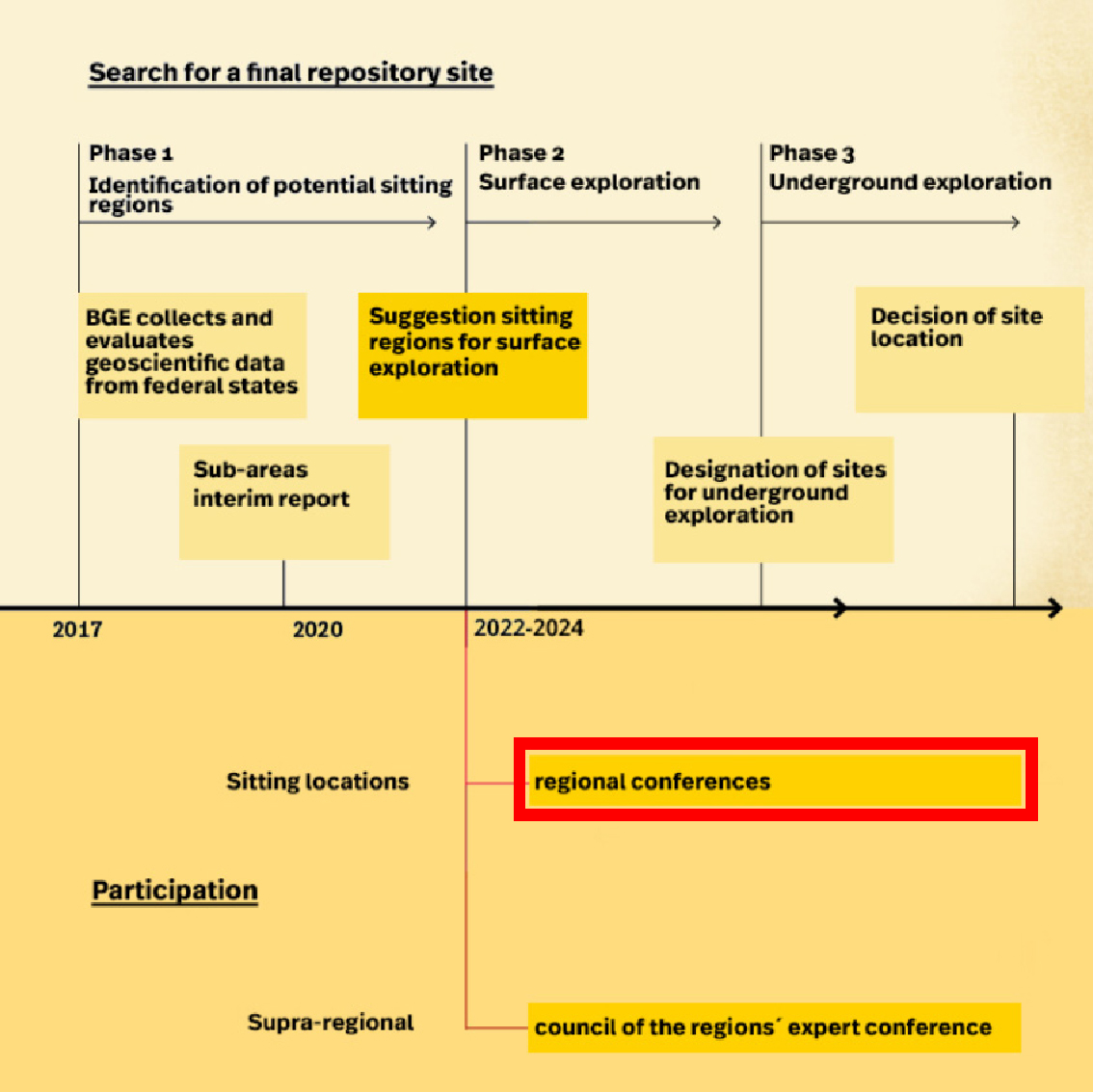
Phase Ⅰ에서 적용되는 부지선정법 제13조는 제22~24조에 명시된 배제조건과 최소요구조건, 지구과학적 가중치 요건을 충족하는 고준위방사성폐기물의 안전한 처분을 위해 유리한 지질학적 조건을 기대할 수 있는 후보부지를 식별해야 한다는 조항으로 이에 따라 BGE는 처분 대상 모암을 암염, 점토암, 결정질암으로 결정하였다(BGE, 2020). Phase Ⅰ - Step 1의 결과로 중간보고서(Sub-areas interim report)가 발표되었고, 그 이후 규제기관인 BASE(Das Bundesamt für die Sicherheit der nuklearen Entsorgung)는 대중참여를 위한 최초의 법적 규제 절차인 지방 당국, 과학자, 사회조직 대표 및 대중으로 구성된 전문가 회의(Specialist Conference Sub-Areas)를 소집한다(BGE, 2023).

Phase Ⅰ - Step 2에서는 Step 1에서 식별된 후보부지를 대상으로 부지선정법 제14조에 따라 지표조사를 수행할 후보부지를 식별한다. 또한 부지선정법 제27조에 따라 대표적인 예비 안전성 평가를 수행하고, 부지의 지표조사를 위한 조사 프로그램을 준비한다. 이 단계에서는 BGE가 지표조사를 수행할 후보부지를 결정하면 BASE는 지역 회의(Regional conference)를 설립하고, 이어서 Phase Ⅱ에서 지역 회의(Regional conference)를 시작한다(Fig. 6)(BASE, 2023).

https://static.apub.kr/journalsite/sites/kseg/2023-033-02/N0520330208/images/kseg_2023_332_335_F6.jpg
Fig. 6.

Regional conferences in Germany (BASE, 2023).

Phase Ⅱ에서는 Phase Ⅰ - Step 2에서 식별된 후보부지를 대상으로 부지선정법 제16조에 따라 지표조사를 수행한다. 조사 결과를 바탕으로 예비 안전성 평가가 수행되며, 심부환경조사를 위한 후보부지를 결정한다(BGE, 2020).

Phase Ⅲ에서는 제18조에 따라 환경영향평가를 위한 문서를 준비한다(BGE, 2020). 또한 Phase Ⅱ에서 결정된 후보부지에 대한 심부환경조사와 종합적인 예비 안전성 평가를 수행하고, 그 결과를 바탕으로 부지선정법 제19조에 따라 최소 2개 후보부지를 비교 및 검토하여 최종부지를 결정한다(BGE, 2020).

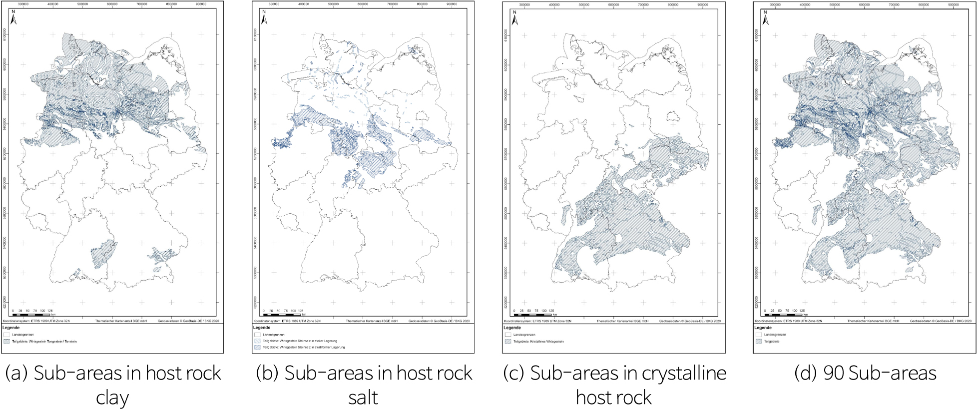
독일은 Phase Ⅰ - Step 1의 결과인 중간보고서(Sub-areas interim report)를 발표하였으며, 이는 독일의 고준위방사성폐기물에 대한 심층처분시설로 가는 첫 번째 단계라고 할 수 있다. 중간보고서에 90개의 후보부지가 식별되었고(Fig. 7), 이는 독일 내에서 240,874 km2 면적이 최종 부지선정에 유리한 지질학적 조건을 가지고 있으며 서로 다른 지질학적 단위로 있어 중첩되는 부분을 제외한 면적은 194,157 km2로 독일영토의 약 54%가 심층처분시설의 후보부지가 된다(BGE, 2020). 현재 독일은 Phase Ⅰ - Step 2를 진행 중이며 90개 후보부지를 대상으로 지표조사 대상 후보부지를 선별하고 있다(BGE, 2020).

https://static.apub.kr/journalsite/sites/kseg/2023-033-02/N0520330208/images/kseg_2023_332_335_F7.jpg
Fig. 7.

General maps of sub-areas in Germany (BGE, 2020).

영국

영국은 1997년에 Shellafield 지역에 방사성폐기물을 처분하려 했던 계획이 지역사회와 사회단체의 강력한 반대로 무산되면서 Decide-Announce-Defend(DAD) 방식의 정책이 실현되지 못했다(Koo, 2016). 따라서 부지선정과 관련해 영국은 지역의 자발적 유치 방식을 채택하고 있다.

2008년에 발간된 백서(the White Paper: Managing Radioactive Waste Safely - A Framework for Implementing Geological Disposal)에 따르면 영국의 부지선정 절차는 Fig. 8과 같이 Stage 1에서 Stage 6으로 나뉘어 있다(Defra et al., 2008). 그러나 2008년에 시작된 부지선정 절차는 5년간 운영되다가 2013년 2월에 참여하는 지역사회가 더 이상 존재하지 않게 되면서 Stage 3에서 중단되었다(DECC, 2014). 그 이후 2014년에 부지선정 참여 주체를 지방정부에서 지역사회로 변경하는 내용의 백서(Implement Geological Disposal: A Framework for the long-term management of higher activity radioactive waste)가 개정되어 발간되었다. 2014년에 발간된 백서는 후보 지역을 식별하기 위해 영국의 지질을 초기 GDF(Geological Disposal Facility) 개발에 대한 대중의 이해를 돕는 과정이 필요하다고 언급했고, 영국 정부는 RWM(Radioactive Waste Management)에게 National Geological Screening Guidance를 만들도록 요청했다(DECC, 2014). Screening Guidance는 영국의 지질연구소(British Geological Survey, BGS)와 같은 전문기관의 자료를 활용하여 작성되었으며, GDF의 안전과 관련된 지질정보를 통합하기 위해 사용되었다. National geological screening guidance는 2016년에 발간되었으며, 천층처분 방식을 선호하는 스코틀랜드를 제외한 잉글랜드, 북아일랜드, 웨일스 지역을 BGS에서 사용하는 13개의 지질학적 지역으로 나누었고, GDF의 장기적 안전과 관련된 지질 환경 측면에 초점을 맞춰 잉글랜드, 웨일스 및 북아일랜드 지하 약 1,000 m 깊이의 지질에 대한 기존 정보의 개요를 제공한다(Fig. 9)(RWM, 2016). Screening Guidance에 따르면 부지선정 지역의 스크리닝을 위한 지질학적 속성의 항목은 암석 유형, 암석 구조, 지하수, 자연적 현상, 자원으로 나뉜다. 상세 내용은 Table 9와 같으며 해당 항목의 자료수집 출처는 Table 10과 같다(RWM, 2016).
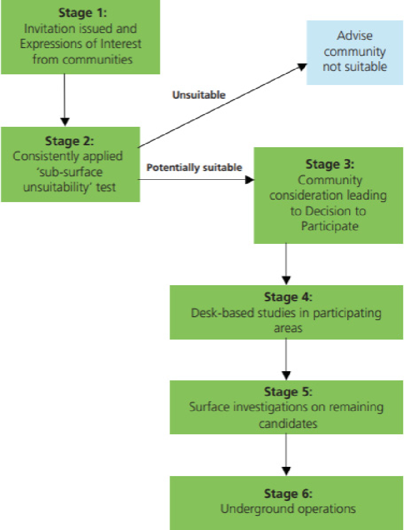
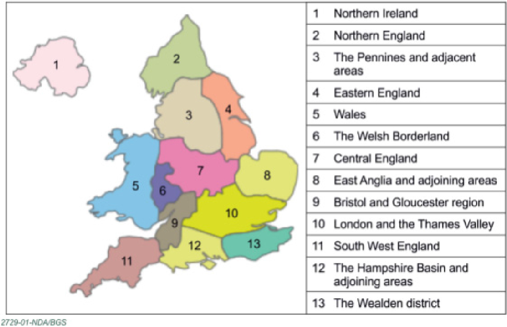
https://static.apub.kr/journalsite/sites/kseg/2023-033-02/N0520330208/images/kseg_2023_332_335_F8.jpg
Fig. 8.

UK site selection process (Defra et al., 2008).

https://static.apub.kr/journalsite/sites/kseg/2023-033-02/N0520330208/images/kseg_2023_332_335_F9.jpg
Fig. 9.

The 13 geological regions in the UK (RWM, 2016).

Table 9.

Geological attributes in the UK (RWM, 2016)

Topic Geological attributes
Rock type - Distribution of potential host rock types (higher-strength rocks, lower-strength sedimentary rocks,
evaporite rocks) at the depths of a Geological Disposal Facility
- Properties of rock formations surrounding host rocks
Rock structure - Locations of highly folded zones
- Locations of major faults
Groundwater - Presence of aquifers
- Presence of geological features and rock types that may indicate separation of shallow and deep
groundwater systems
- Locations of features likely to permit rapid flow of deep groundwater to near-surface environments
Natural processes - Distribution and patterns of seismicity
- Extent of past glaciations
Resources - Locations of existing deep mines
- Locations of intensely deep-drilled areas
- Potential for future exploration or exploitation of resources
Table 10.

Principal information sources in the UK (RWM, 2016)

Topic Geological attributes
Rock type - British Geological Survey (BGS) maps, memoirs and stratigraphic summaries
- BGS UK3D model
Rock structure - BGS 1:1,500,000 “Tectonic map of Britain, Ireland and adjacent areas”
- BGS 1:1,000,000 map and contour overlay “Pre-Permian geology of the United Kingdom (South)”
- 1:50,000 BGS solid geology maps and supporting memoirs
Groundwater - Information gathered under rock type and rock structure topics
- Information gathered under resources about existing deep mines and offshore boreholes
- Maps of the distribution of aquifers in England, Wales, and Northern Ireland
- BGS/EA baseline chemistry and dominant geochemical processes report series
Natural processes - BGS, National Nuclear Laboratory, University of Manchester Dalton Nuclear Institute Potential
Natural Changes and Implications for a UK GDF. Minerals and Waste Programme Commissioned
Report CR/12/127. 2012
- BGS, Regional modelling of the potential for permafrost development in Great Britain. Minerals and
Waste Programme Commissioned Report CR/14/023 73. 2014
Resources - BGS 1:1500,000 Coal Resources map
- DECC published information on conventional and unconventional hydrocarbons
- BGS 1:1500,000 Metallogenic Map (1996)
- BGS County Mineral Resource maps and reports
- BGS Economic Geology Memoir series
- BGS BRITPITS dataset
- BGS Geolndex, NIINDEX and Off-shore Borehole Database for information on onshore and offshore
boreholes
- BGS Geothermal Prospectivity Map

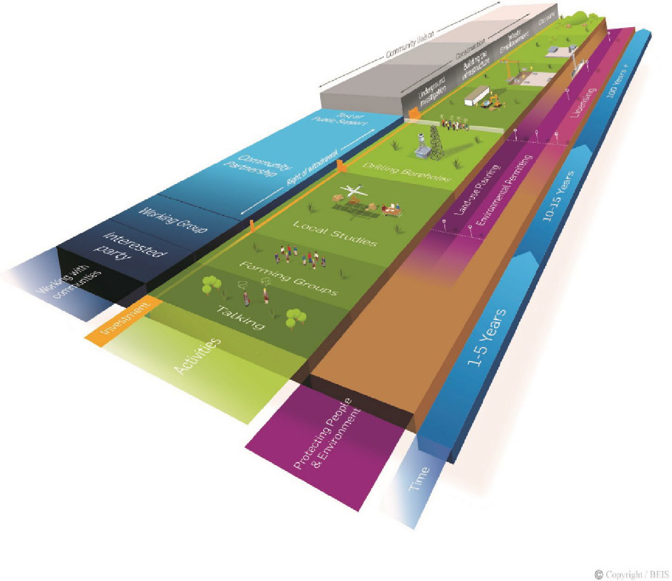
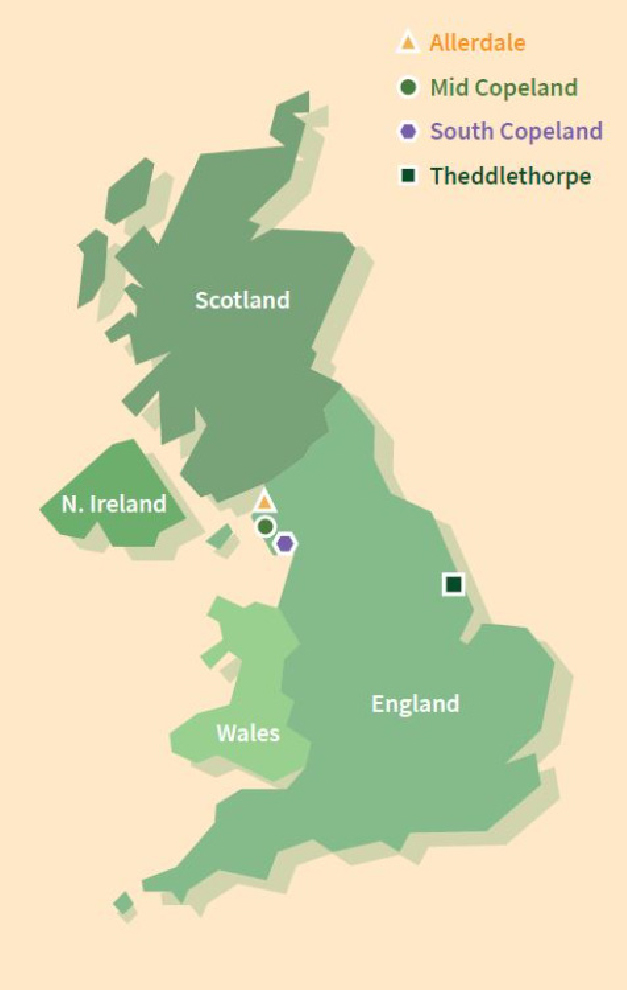
영국 정부는 2018년 12월에 백서(Implementing Geological Disposal - Working with Communities: An updated framework for the long-term management of higher activity radioactive waste)를 개정하여 지역사회 정의 및 참여방안 등을 명시했으며 지역사회와 협력하기 위한 프로세스를 추진 중이다. 백서에 따르면 영국의 부지선정 과정과 추진내용은 Fig. 10과 같으며, 1~5년간은 부지선정을 위해 관심을 표명한 지역에서 Local study가 진행되고, 10~15년간에는 상세 조사를 하여 부지를 확정하는데 지역사회는 이 기간 내에 언제든 부지선정 참여 의사를 철회할 수 있다. 부지 확정 이후에는 100년 이상의 기간 동안 시설 건설 및 운영에서 폐쇄까지 계획하고 있다(BEIS, 2018). 2018년 12월에 잉글랜드가 참여 의사를 밝히면서 GDF 부지선정 과정이 시작되었으며, 2019년 1월에 웨일스도 GDF 부지선정 과정에 참가한다고 공표했다. 현재 영국에서는 잉글랜드의 Mid Copeland와 South Copeland, Allerdale, Theddlethorpe 지역이 관심을 표명하여 GDF Community Partnership을 결성하였고(Fig. 11)(GOV.UK, 2022), 2022년 1월 RWM에서 개편되어 관련 업무를 이어받아 수행 중인 NWS(Nuclear Waste Services)는 계속해서 GDF Community Partnership에 참가할 지역을 모집할 예정이다.

https://static.apub.kr/journalsite/sites/kseg/2023-033-02/N0520330208/images/kseg_2023_332_335_F10.jpg
Fig. 10.

Process for the implementation of geological disposal in the UK (BEIS, 2018).

https://static.apub.kr/journalsite/sites/kseg/2023-033-02/N0520330208/images/kseg_2023_332_335_F11.jpg
Fig. 11.

GDF community partnership in UK (GOV.UK, 2022).

부지선정 방식 비교

처분 선도국의 부지선정 방식에서 알 수 있는 공통점으로는 법과 제도를 먼저 만들고 부지선정 과정을 시작했다는 것, 각 나라의 지질 조건에 따라 부지선정 항목을 선정하고 이를 토대로 전국 규모에서 최종 1개의 부지를 선정하기까지 후보부지가 순차적으로 줄어들 수 있도록 부지선정 과정을 진행한다는 것이다.

그러나 처분 선도국의 부지선정 방식은 주민참여 시기를 기준으로 크게 세 가지로 구분할 수 있었다. 첫 번째는 정부 주도로 후보부지를 결정하여 부지를 공표하여 부지를 선정하는 방식이고, 두 번째는 기존 조사자료를 바탕으로 배제지역을 제외한 후 지역사회와의 지속적인 소통을 통해 부지를 선정하는 방식이고, 세 번째는 자발적 참여 의사를 밝힌 지역사회를 대상으로 부지선정을 하는 방식이다(Fig. 12).

https://static.apub.kr/journalsite/sites/kseg/2023-033-02/N0520330208/images/kseg_2023_332_335_F12.jpg
Fig. 12.

Proposed site selection method.

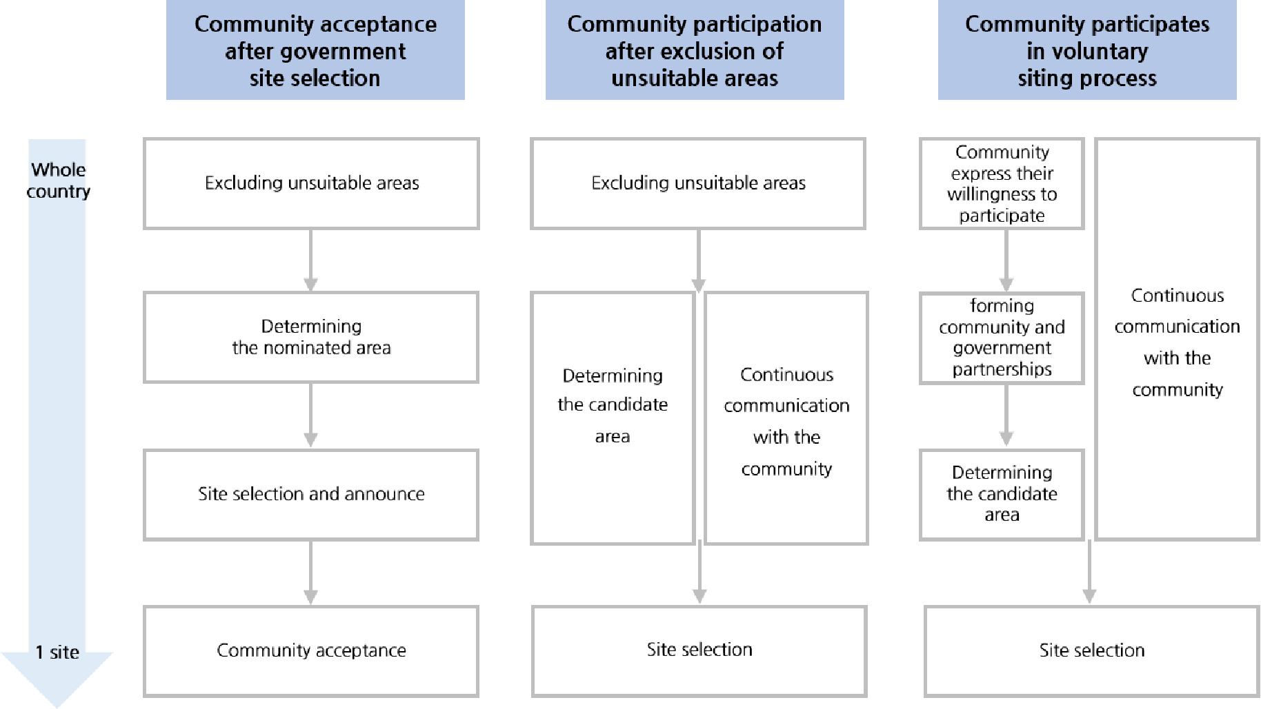
첫 번째 방식은 전국 규모에서 기존 조사자료에 따른 배제지역을 제외한 후, 상세 조사를 통해 부지를 선정하고, 이를 공표하여 주민과 지역사회의 동의를 구하는 부지선정 방식으로 미국의 사례가 대표적이다. 현재 이 방식에 따라 미국은 Yucca Mountain으로 부지선정을 한 뒤, 더 진행하지 못하고 Yucca Mountain이 속해있는 네바다주의 주지사와 환경단체의 반대로 중단이 된 상태이다.

두 번째 방식은 기존 조사자료에 따라 배제지역을 제외한 후에 지역사회와 지속적인 소통을 하여 선별된 해당 지역에 대해 상세 조사를 해서 부지를 선정하는 방식으로 스웨덴, 스위스, 독일의 경우가 대표적이다. 이것이 첫 번째 방식과 다른 점은 지역사회가 부지선정 과정에 참여해 소통과 협의를 한다는 것인데, 스웨덴과 스위스는 3단계 중 2단계부터 지역사회의 참여가 시작되고, 독일은 3단계 부지선정 과정 중 1단계의 Step 2부터 지역사회의 참여가 시작된다.

세 번째 방식은 자발적 참여 의사를 밝힌 지역을 대상으로 부지선정을 하는 방식이다. 이 방식으로 부지선정 과정을 진행하는 영국은 과정 전반에 걸쳐 지역사회와 소통 및 협력을 하는데, 심층처분 방식(Geological Disposal)을 선호하는 지역이 참여 의사를 표명하면 지역사회와 정부의 파트너십이 결성되고, 지역사회와 지속적인 소통을 통해 상세 조사를 하여 후보부지를 결정한다.

처분 선도국의 부지선정 과정의 비교 분석 결과, 지역 주민들의 의견이 반영되는 시기와 각 나라별 지질학적 상황에 따른 선별기준이 서로 달랐다(Table 11). 첫 번째 방식과 같이 정부 주도로 후보부지를 결정하여 부지를 선정하는 미국의 경우 지역사회 소통의 부재로 인한 의견 충돌로 처분시설 건설까지 진행되지 못했다. 두 번째 방식은 기존 조사자료를 통해 배제지역을 제외하고 그 이후 지역사회와 지속적으로 소통하며 진행했다는 것이 큰 특징으로, 스웨덴과 스위스는 이 방식을 통해 부지선정을 완료했으며, 독일도 이 방식에 따라 부지선정을 진행 중이다. 영국의 경우에 해당되는 세 번째 방식은 자발적 참여 의사를 밝힌 지역사회를 대상으로 부지선정을 하는 방식으로, 초기 단계부터 지역사회와의 확실한 소통을 통해 처분시설 건설에 대한 반발을 최소화한다는 점을 특징으로 볼 수 있다.

Table 11.

Comparison of site selection methods

USA Sweden Switzerland Germany UK
Site selection
method
Community
acceptance after
government site
selection
Community
participation after
exclusion of
unsuitable areas
Community
participation after
exclusion of
unsuitable areas
Community
participation after
exclusion of
unsuitable areas
Community
participates in
voluntary siting
process
Site selection
period
- 17 years
(1992-2009)
14 years
(2008-2022)
- -
Siting stages Stages 1-2 Phases 1-3 Stages 1-3 Phases 1-3 Stages 1-6
Timing of
community
participation
No participation Phase 2 Stage 2 Phase 1, Step 2 Overall
Criteria for
site selection
Geohydrology
Geochemistry
Rock characteristics
Climatic changes
Erosion
Dissolution
Tectonics
Human interference
Topography
Soil strata
Rock type
Plastic structures
Brittle structures
Mechanical stability
Thermal properties
Geological events
Properties of
host rock
Long-term stability
Reliability of
geological database
Engineering
suitability
Large-scale vertical
movements
Active fault zones
Influences from
current or past
mining activities
Seismic activity
Volcanic activity and
young groundwater
age
Rock type
Rock structure
Groundwater
Natural processes
Resources
Current progress Suspension of site
selection
Site selection
complete
Site selection
complete
Phase 1, Step 2 Local study and
recruitment to
community
partnership
Whole country
→ 9 sites
→ 5 sites
→ 3 sites
→ 1 site
(Yucca Mountain)
→ Suspension
Whole country
→ 8 sites
→ 2 sites
→ 1 site
(Forsmark)
Whole country
→ 6 sites
→ 3 sites
→ 1 site
(Nördlich Lägern)
Whole country
→ 90 sites
→ in progress
Countries except
Scotland
→ in progress

토의 및 결론

우리나라의 경우에도 2030년부터 원전 내 사용후핵연료 임시 저장시설이 포화되기 시작하고(MOTIE, 2023), 이에 따라 정부에서는 고준위방사성폐기물 처분을 위한 부지선정 추진을 준비하고 있다. 부지선정 과정 자체를 법으로 제정하여 부지선정에 착수한 독일이나 여러 번의 백서의 개정을 통해 지역사회의 자발적 참여를 우선으로 한 영국, 긴 시간 동안 차근차근 처분 부지선정 절차를 밟아 부지선정에 완료한 스웨덴과 스위스, 자체평가를 통해 Yucca Mountain을 최종 처분부지로 선정하려다 지역과 환경단체의 반대로 무산된 미국 등은 우리에게 시사하는 바가 크다. 무엇보다도 법과 제도를 확정하는 것을 우선으로 하여, 이에 따라 부지선정을 추진하고 이 과정에서 투명한 절차로 과학적 근거에 기반하여 지역사회와의 지속적인 소통을 통해 부지선정을 추진해 나가야 할 것이다.

Acknowledgements

이 논문은 2023년도 정부(산업통상자원부)의 재원으로 사용후핵연료관리핵심기술개발사업단 및 한국에너지기술평가원의 지원을 받아 수행된 연구사업(No. 2021040101003A)의 지원으로 수행되었습니다.

References

1
BASE, 2023, Regional conferences, Retrieved from https://www.endlagersuche-infoplattform.de/webs/Endlagersuche/EN/participation/regional-conferences/regional-conferences_node.html (in German).
2
BEIS, 2018, Implementing geological disposal - working with communities: An updated framework for the long-term management of higher activity radioactive waste, 29-30.
3
BGE, 2020, Interim report sub-areas according to § 13 StandAG, 22-435 (in German).
4
BGE, 2023, Site selection procedure, Retrieved from https://www.bge.de/de/endlagersuche/standortauswahlverfahren/ (in German).
5
CONGRESS.GOV, 2019, S.1234 - Nuclear waste administration act of 2019, Retrieved from https://www.congress.gov/bill/116th-congress/senate-bill/1234/text.
6
DECC, 2014, Implementing geological disposal: A framework for the long-term management of higher activity radioactive waste, 7-9.
7
Defra, BERR, Welsh Assembly Government, Department of the Environment Northern Ireland, 2008, Managing radioactive waste safely: A framework for implementing geological disposal, 1-12.
8
DOE, 1984, General guidelines for the preliminary screening of potential sites for a nuclear waste repository, US Code of Federal Regulations Title 10, Chapter III Department of Energy, Part 960.
9
GOV.UK, 2022, NWS welcomes Theddlethorpe GDF Community Partnership formation, Retrieved from https://www.gov.uk/government/news/nws-welcomes-theddlethorpe-gdf-community-partnership-formation.
10
Koo, G., 2016, Persuasion and investigation for coordination - The case of the UK radioactive waste management board and facilitation as ADR, Spring 2016, 1-3 (in Korean).
11
MOTIE (Ministry of Trade, Industry and Energy), 2021, The second basic plan for high-level radioactive waste management (in Korean).
12
MOTIE (Ministry of Trade, Industry and Energy), 2023, Prediction to reduce saturation of spent fuel storage facilities by 1 to 2 years, Retrieved from http://www.motie.go.kr/motie/ne/presse/press2/bbs/bbsView.do?bbs_cd_n=81&bbs_seq_n=166780 (in Korean).
13
ORNL, 1996, An account of the programs of federal agencies and events that have led to the selection of a potential site for a geologic repository for high-level radioactive waste, TM-12940, 15, 129-194.
14
Philip, J., 2005, Responsibilities and regulations for geologic disposal of high-level radioactive waste in the U.S., 1-13.
15
RWM, 2016, National geological screening guaidance, 14-21.
16
SFOE, 2008, Sectoral plan for deep geological repositories-conceptual part, Department of the Environment, Transport, Energy and Communications/SFOE, Bern, Switzerland, 5-40.
17
SFOE, 2022, Newsletter deep geological repositories September 2022, Retrieved from https://www.nlt.admin.ch/f/view.aspx?1DD31527652DB2E636364DB36686364DD3F697852DB3668746B98AF343 (in German).
18
SKB, 1995, General Siting Study 95. Siting of a deep repository for spent nuclear fuel, Technical Report 95-34, 12-143 (in Swedish).
19
SKB, 2000, Geoscientific programme for investigation and evaluation of sites for the deep repository, Svensk Kärnbränslehantering AB, SKB TR-00-20, 10-114 (in Swedish).
20
SKB, 2011, Site selection - siting of the final repository for spent nuclear fuel, Svensk Kärnbränslehantering AB, SKB R-11-07, 1-14 (in Swedish).
21
SKB, 2020, Long process nearing completion, Retrieved from https://www.skb.com/news/long-process-nearing-completion/ (in Swedish).
22
SKB, 2022, The government approves SKB's final repository system, Retrieved from https://www.skb.com/news/the-government-approves-skbs-final-repository-system/ (in Swedish).
23
WNWR, 2019, World nuclear waste report 2019 focus Europe, Berlin & Brussels, Retrieved from https://worldnuclearwastereport.org/.
페이지 상단으로 이동하기