

Introduction
Study area
Analysis of surface geological and borehole data
Surface geology
Analysis of borehole data
Analysis of samples
Sampling
ICP analyses
Analytical results
Conclusion
Introduction
Acid drainage is generally produced by reactions of metal wastes containing sulfides with oxygen and water in natural weathering environments. Sulfides are a major cause of pollution of surface water, groundwater, and soil because of their low pH and high concentrations of sulfate and metal ions (Kelly, 1988; Sengupta, 1993; Michaud, 1995; Akcil and Koldas, 2006), with acid drainage being generated by their reaction with oxygen when exposed during civil engineering work. In addition to environmental pollution, acid drainage may cause engineering and economic problems through the promotion of rock weathering, corrosion, and instability of structures (Koryak et al., 1972; Lee et al., 2013; Kim et al., 2014). Pyrite is a common sulfide produced by diverse geological processes such as sediment diagenesis, precipitation by hydrothermal alteration during mineralization, reactions of hydrothermal solutions with rocks, and metamorphism (Lee et al., 2013). Iron in pyrite is reduced through reactions with fluids flowin into surrounding ground or structures, and is deposited as reddish a brown hydroxide, Fe(OH)2, or oxide, FeO (Kim, 2007). Therefore, when acid drainage containing Fe flows into structures such as tunnels, precipitates are formed, leading to the clogging of drainpipes. This results in the loss of function of drainage systems, and leakage and seepage within the tunnel. Most examples of poor drainage in tunnels have been attributed to acid drainage (Im et al., 2013). A study of precipitates in subway tunnels confirmed that the reddish brown deposits were generated by Fe-rich acid drainage (Woo, 2005). Contaminants in acid drainage on slopes have been found to include mainly H+, Al, Fe, and Mn ions (Lee et al., 2005). Determination of Fe contents of drainage water and precipitates, and the reddish brown coloration of rock surfaces, rivers, and soils may therefore be important in evaluating problems related to acid drainage. Studies of acid drainage in South Korea have focused mainly on water pollution in coal mines, associated geochemical characteristics, and methods for the treatment of acid drainage (Park et al., 2000; Yu and Coleman, 2000; Kim and Kim, 2002; Youm et al., 2002; Cheong, 2004; Choi et al., 2004; Choo et al., 2004; Cui et al., 2009). There have been relatively few studies of acid drainage associated with the construction industry (Choi et al., 2001; Lee et al., 2005; Woo, 2005; Kim, 2007; Lee et al., 2013).
In this study, acid drainage was examined as a possible source of reddish brown seepage water in the tunnel. The surrounding geological environment was investigated through study of outcrops in the upper parts of the tunnel. Borehole data were also analyzed. Inductively coupled plasma (ICP) spectrophotometry was applied to determine the Fe content of acid drainage through analysis of seepage water and precipitates collected from perforated drainpipes and pavements in the tunnel. Results were compared with the Fe contents of soils and groundwater collected from the tunnel surroundings.
Study area
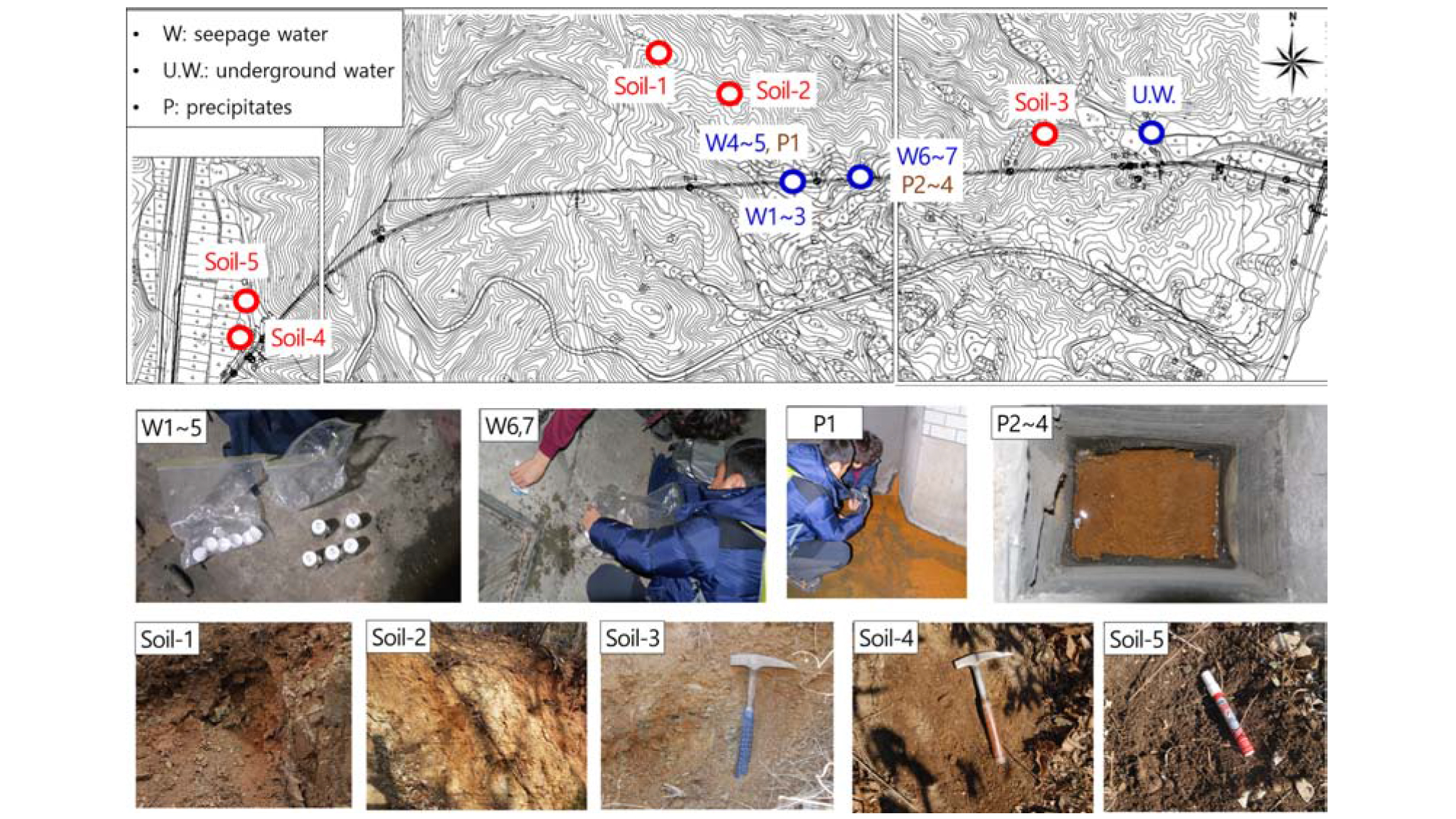
The study area is dominated by Cretaceous sedimentary rocks, Late Cretaceous intrusive igneous rocks, and Tertiary volcanic rocks. The sedimentary rocks differ from the upper strata of the Gyeongsang Group, comprising alternating mudstone, sandstone, and black shale (Tateiwa, 1922). The tunnel lies in sandstone in the western segment and granite in the east (Fig. 1). The boundary between sedimentary rocks and granite is located in the middle area of the tunnel, and faults, dykes, and zones of hydrothermal alteration are likely to exist along this boundary.
Reddish brown seepage water is observed in only part of the tunnel, over a length of ~140 m. It flows from the sidewall of a cross-passage towards the portal, along the shoulder of the tunnel pavement. Backflow is observed in some of the perforated drainpipes located below the pavement.
Analysis of surface geological and borehole data
Surface geology
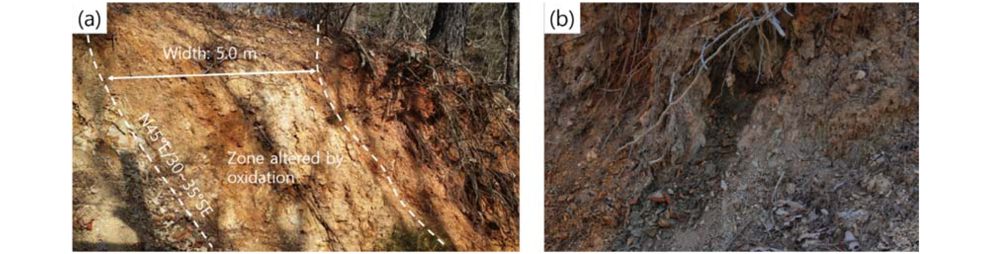
Surface geology was investigated through study of an outcrop located at the surface, ~360 m northwest of the seepage zone (Fig. 1). The outcrop is cut by a hydrothermal alteration zone (~5 m wide) that strikes N45°E and dips 30°-35° to the SE, and is oxidized to a reddish brown color (Fig. 2a). Bedrock in the study area is weathered sedimentary rock that occurs around the hydrothermal lteration zone, with reddish-brown rock fragments being partially visible (Fig. 2b). The boundary between sedimentary rock and granite is located near this outcrop (Fig. 1). The hydrothermal alteration zone is considered to have developed through the intrusion of acidic dykes and the migration of hydrothermal solutions along fracture zones and discontinuities that formed when the granite was intruded.
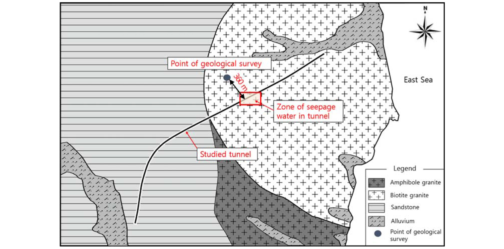
The cross-sectional extrapolation line was estimated from strike and dip measured in the outcrop. This indicates that the alteration zone is located 40-50 m from the seepage zone in the tunnel (Fig. 3). The total depth of the hydrothermal alteration zone cannot be accurately determined, although estimates based on the boundary between rock types (Fig. 1) and surface geological features indicate that hydrothermal alteration zones, fracture zones, and veins are likely to occur in the vicinity of the tunnel.

Analysis of borehole data
Borehole data from around the seepage zone were analyzed to improve our understanding of deep geological conditions (Fig. 4). The analysis results for core TB-4 indicate total core recoveries (TCR) and rock quality designations (RQD) of <60% and 20% at depths of 74–90 m and tunnel depths of 112-125 m, respectively (Fig. 4a). The rocks have been severely altered by faults or hydrothermal solutions at depths of 50-56 m, 72-81 m, and 119-122 m, as observed in the drillcore shown in Fig. 4b. At depths of 3-27 m, joints are partially covered with reddish brown material. The TB-5 core yields an RQD value of <40% at most depths, and <10% at depths of 15-50 m (Fig. 5a). The rocks have been broken down due to severe weathering, with most having yellow or reddish brown coloration (Fig. 5b). Veins were observed in both TB-4 and TB-5.
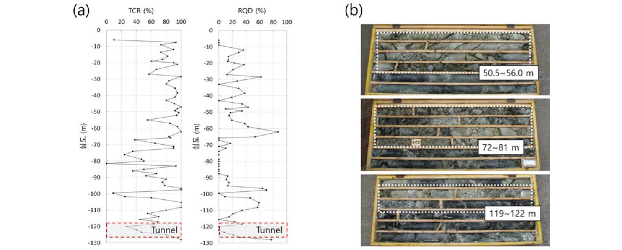
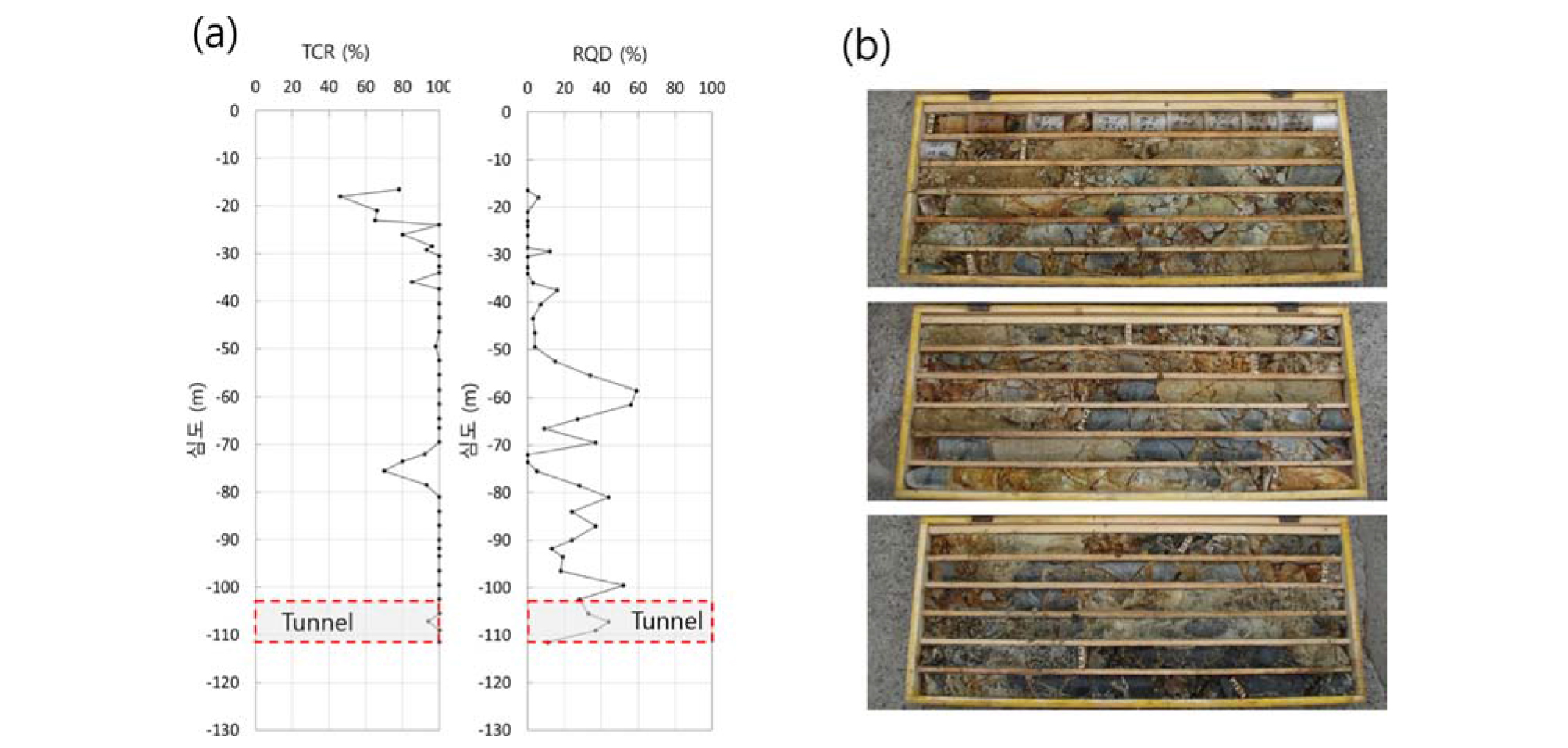
Surface geological investigations and borehole data together indicate that rocks around the seepage zone have been severely weathered or crushed, with many veins and hydrothermal alteration zones including acidic components.
Analysis of samples
Sampling
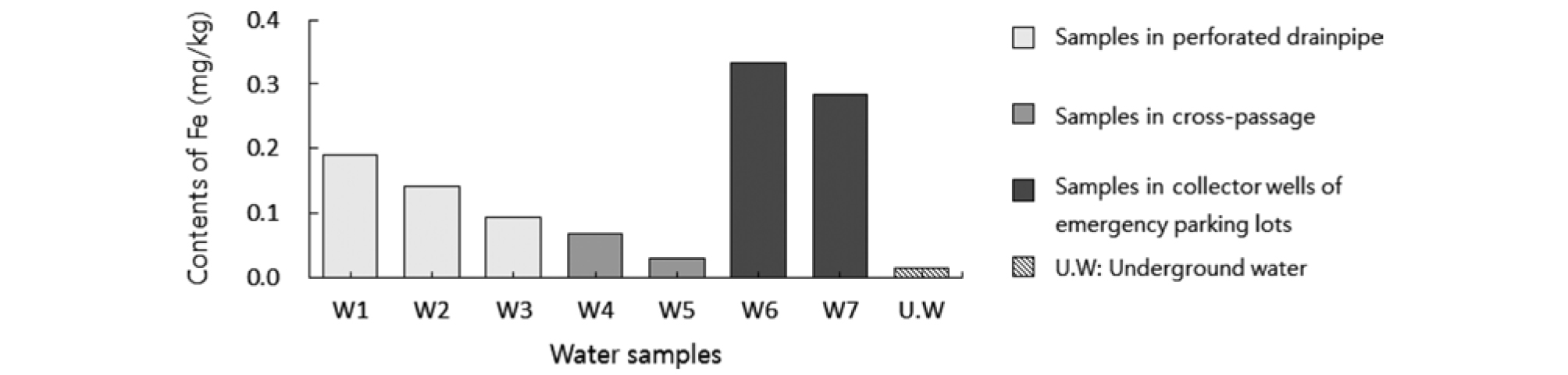
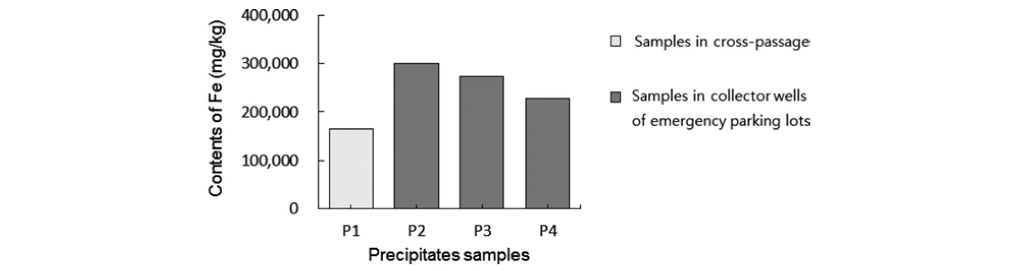
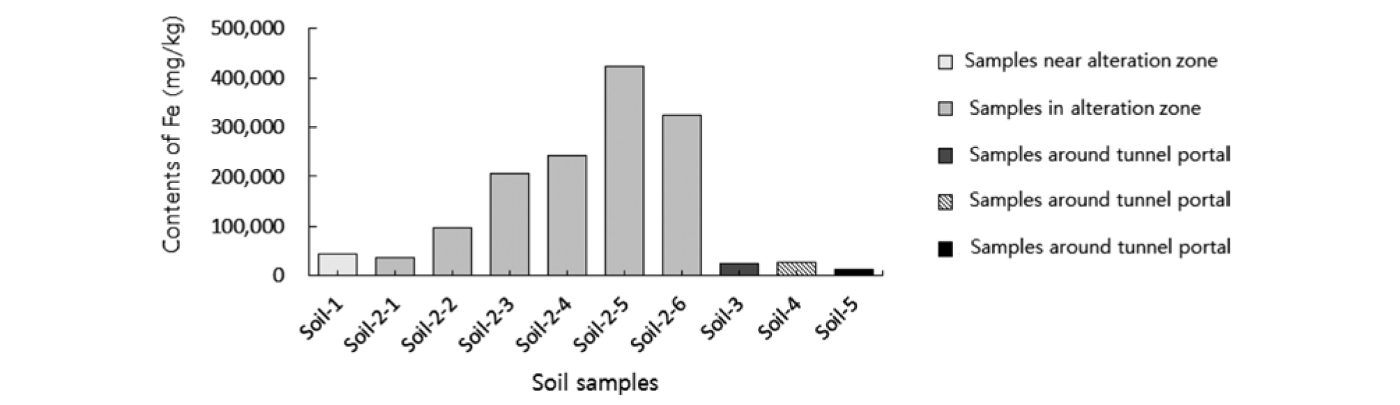
Samples were collected for quantitative analysis of Fe in seepage water, precipitates, and soil around the tunnel (Fig. 6). Water samples (n=7) and precipitates (n=4) were collected from tunnel side-walls in the cross-passage where seepage water was present, and from perforated drainpipes and collector wells. Groundwater (n=1) was collected from a nearby river, and soil samples (n=10) were collected from the hydrothermal alteration zone and outcrops around the tunnel portal.
ICP analyses
Quantitative ICP analyses were conducted for Fe contents of the samples, using an OPTIMA 7300DV spectrophotometer (Perkin Elmer). Analyses of seepage and groundwater samples were conducted after the removal of suspended materials by filtration. Soil samples were analyzed after powdering and drying at 60°C. Precipitate samples passing through a 0.075 mm sieve were analyzed.
Analytical results
The Fe contents of samples W1-W3 (0.094-0.190 mgnm/kg), collected from perforated drainpipes, were higher than those of W4 (0.068 mg/kg) and W5 (0.030mg/kg) collected from the side-wall of the tunnel cross-passage (Fig. 7). The Fe contents of samples W6 and W7, from collector wells of emergency parking lots in the tunnel were 0.333 and 0.284 mg/kg, respectively, with these being the highest measured (Fig. 7). These results are attributed to the deposition of Fe while water was flowing through the perforated drainpipes and collector wells for long periods of time. The Fe content of the seepage water (0.030-0.333 mg/kg) in the tunnel was 2-22 times higher than that of the groundwater around the tunnel (0.015 mg/kg).
The Fe content of precipitates was 165,403-301,051 mg/kg. The contents of samples S2-S4 (from collector wells of the emergency parking lot) are 1.4-1.8 times higher than that of sample S1 (from the side-wall of the cross-passage) (Fig. 8).
Soil samples collected around the tunnel have Fe contents of 13,961-422,964 mg/kg (Fig. 9). The Fe contents of cores from the hydrothermal alteration zone (soil samples 2-3 to 2-6) were 206,167-422,946 mg/kg, similar to precipitates in the tunnel. This suggests that the hydrothermal alteration zone extended to depth around the tunnel, with Fe flowing in solution from the zone into the perforated drainpipes along nearby fracture zones. Soil samples collected at other points have Fe contents of 13,964-43,226 mg/kg, lower than those of the hydrothermal alteration zone.
Conclusion
In this study, acid drainage was evaluated for reddish brown seepage water that occurred in the tunnel. To analyze the geological environment around the zone of seepage water, a surface geological investigation was conducted on the hydrothermal alteration zone located in the upper part of the tunnel, and deep geological features were identified by analyzing borehole data. Fe contents were measured by ICP analysis for water and precipitates samples collected in the zone of seepage water. Then, the results were compared and analyzed with the Fe contents of groundwater and soil samples collected from near the tunnel.
The conclusions of this study of tunnel seepage water are as follows.
1. The hydrothermal alteration zone is likely to extend to near the deep tunnel, as many fracture zones and veins are observed in drillcore.
2. The Fe content of seepage water in the tunnel was 0.030-0.333 mg/kg, which is 2-22 times higher than that of groundwater around the tunnel (0.015 mg/kg).
3. The Fe content of seepage water in perforated drainpipes and collector wells (0.094-0.333 mg/kg) was higher than that of water collected from tunnel side-walls (0.030-0.068 mg/kg), reflecting the deposition of Fe during drainage through perforated drainpipes and collector wells over long periods.
4. The Fe content of precipitates in the tunnel was 165,403-301,051 mg/kg. The Fe contents of precipitates in collector wells (227,934-301,051 mg/kg) were 1.4-1.8 times higher than that of the tunnel side-wall (165,403 mg/kg).
5. In tunnel surroundings, the Fe content of soil samples from the hydrothermal alteration zone was 206,167-422,964 mg/kg, similar to that of precipitates in the tunnel. This is attributed to groundwater flowing into perforated drainpipes in the tunnel, along the fracture zones and veins around the hydrothermal alteration zone.
