

Introduction
Geological Background
Materials and Methods
Results and Discussion
Marginal Faults
Intra-Basinal Structures
Opening Mechanism of the Yeonghae basin
Conclusion
Introduction
Strike-slip basins are characteristically developing structures along strike-slip faults. They develop in extensional zones and are frequently inverted into transpressional zones (Nilsen and Sylvester, 1999). Furthermore, they can evolve into various shapes and sizes (Aydin and Nur, 1982; Mann et al., 1983; Nilsen and Sylvester, 1999), depending on the cumulated stress and displacement. Hence, they are classified into various types based on their geometry and kinematic setting (Nilsen and Sylvester, 1999). At the fault bends of strike-slip faults, pull-apart basins are developed resulting from subsidence of elongated or lazy-Z-shape at extensional zones (Mann et al., 1983). The pull-apart basins develop into rhomboid-shaped stepover basins due to continuous propagation and overlap of unconnected parallel or sub-parallel master faults. At the ends of strike-slip faults, fault-termination basins also form because normal or oblique-slip faults splay off to terminate and accommodate the deformation field (Umhoefer et al., 2007).
Several strike-slip basins were developed along the southeastern margin of the Korean peninsula, during the Tertiary. It is suggested that the opening of these basins are associated with the opening of the East Sea (Ingle Jr., 1992; Lee et al., 1992; Jolivet et al., 1994; Yoon and Chough, 1995; Yoon et al., 1997). Son (1998) concluded that most of these basins are bonded by NNW-dextral strike-slip faults and NNE to NE trending normal faults and the basin fills indicate northwest dipping half-graben geometry. For example, the Early to Middle Miocene Eoil basin is a pull-apart basin bounded by strike-slip and normal faults. Basin fills reveal that the Eoil basin initiated similar to a rift basin characterized by a series of normal faults developed between the master strike-slip faults, and later on developed into a pull-apart basin due to a progressive increase in strike-slip movement (Son et al., 2000).
The Chongja basin is another Tertiary basin, the basin is developed as a strike-slip, syndepositional tectonic basin characterized by rhomboid-shaped marginal faults. The NW margin is bounded by a listric normal fault whereas the SW margin is bounded by a right-lateral strike-slip fault (Son and Kim, 1994).
In this paper, we present the structural features of the NNE-SSW-trending Yeonghae basin, located along the eastern margin of the Korean peninsula, at the northeastern part of the Yangsan fault (YSF), a potential active strike-slip fault (Fig. 1a). This study aims to investigate the architecture of the intra-basinal structural elements and the kinematic of the master faults to understand the developing mechanism of the Yeonghae basin. For this study, we collected structural data around the basin marginal faults. The outcomes of this study can enhance our understanding for the evolution of the Yeonghae basin and the Yangsan fault system (YSFS).
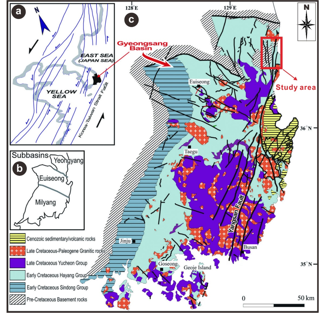
Fig. 1.
(a) Cretaceous strike-slip fault systems around the Korean Peninsula, (b) Tectonic divisions of the Gyeongsang basin, and (c) Geological map of the Gyeongsang basin (modified from Kang and Paik, 2013).
Geological Background
The collision between the North and South China blocks during the late Paleozoic to early Mesozoic resulted in the northeast-trending Tancheng-Lujiang fault system (Tan-Lu fault system) (Yin and Nie, 1993). In the late Triassic, the mega-scale, Tan-Lu fault system underwent a sinistral transcurrent movement (Meng and Zhang, 1999) as a result of the oblique subduction of the Izanagi plate under the Asian plate (Otsuki, 1985). The movement continued to the Jurassic and Cretaceous (Xu et al., 1987). In the middle-late Early Cretaceous, this sinistral movement, including numerous left-stepping en echelon strands associated with volcanic activity, produced many grabens and half-grabens in the Korean peninsula. As the tectonic process progressed, the grabens coalesce into composite grabens forming non-marine sedimentary basins in the Korean peninsula (Lee et al., 1999).
The Gyeongsang basin located in the southeastern part of the Korean peninsula is one of these basins (Fig. 1a, b). This basin differs markedly from other basins in terms of scale and structure and includes several Tertiary sub-basins. Tectonically, the Gyeongsang basin is divided into three blocks; Yeongyang, Uiseong, and Miryang (Chang, 1977; Fig. 1c). These blocks are cut by two systematic sets of strike-slip faults; the Gaum fault zone and the Yangsan fault zone. The Gaum fault zone is a sinistral strike-slip fault trending in WNW-ESE and predominant in the Uiseong block, whereas the Yangsan fault zone is a dextral strike-slip fault trending in NNE-SSW and predominant in the Miryang block (Fig. 1c).
This study is conducted in the northern part of the Gyeongsang basin-Yeongyang block (Fig. 1c). The YSF is the major structure in the study area, which is characterized by a variable width of damage zone (Chang, 2001). It is interpreted that the YSF is developed in the Eocene (Chang et al., 1990) as a right-lateral strike-slip fault, and later on the movement had changed into a sinistral movement (Chae, 1994; Chang and Chang, 1998; Chang, 2001) and then the fault reactivated again as a dextral strike-slip fault in the Quaternary. The total offset of the dextral movement is estimated to be 35 km, evidenced by the offsetting of A-type granitic rocks across the fault (Chang et al., 1990).
The stratigraphic sequence of the study area includes Precambrian gneiss and metasedimentary rocks, Jurassic Yeongdeok granite, Cretaceous non-marine sedimentary rocks, Middle-to-Late Cretaceous volcanic rocks of Yucheon group, Early Cenozoic granite and volcanic rocks of Bulguksa Group, Tertiary sedimentary rocks, and Quaternary sediments (Hatae, 1937; Chang, 1985, 1988; Chang et al., 1990; Fig. 2).

Materials and Methods
Remote sensing analysis was carried out using the ASTER GDEM data, version 2, 2011, downloaded from the United States Geological Survey (USGS) website. Hillshade images and three-dimensional views were produced from ASTER GDEM data. These products were generated using the ArcGIS and ArcScene software by applying the Hillshade processing technique. These image products were used to highlight, detect and analyze the structural features in the study area. Furthermore, they were used to select suitable sites for fieldwork.
Fieldwork was carried out to investigate the nature of the marginal faults and to collect geological and structural data from the study area. Through the fieldwork, rock types and field relationships have been studied. The orientation data such as strikes, dips, and dip directions were collected for various structural elements including bedding plains, veins, dikes, fractures, and faults. The documented kinematic indicators are used to interpret the sense of movement along faults such as slickenlines, S-C fabrics of gouge, and secondary fractures (Hancock, 1985; Means, 1987; Petit, 1987; Stewart and Hancock, 1991; Kim et al., 2003, 2004).
Results and Discussion
Marginal Faults
Remote sensing analysis and fieldwork investigation reveal that the Yeonghae basin is bounded by three major faults. The eastern margin is controlled by the YSF, whereas the western margin is bounded by two sub-parallel faults; Baekseokri fault (BSF) and Gakri fault (GF) (Fig. 3).
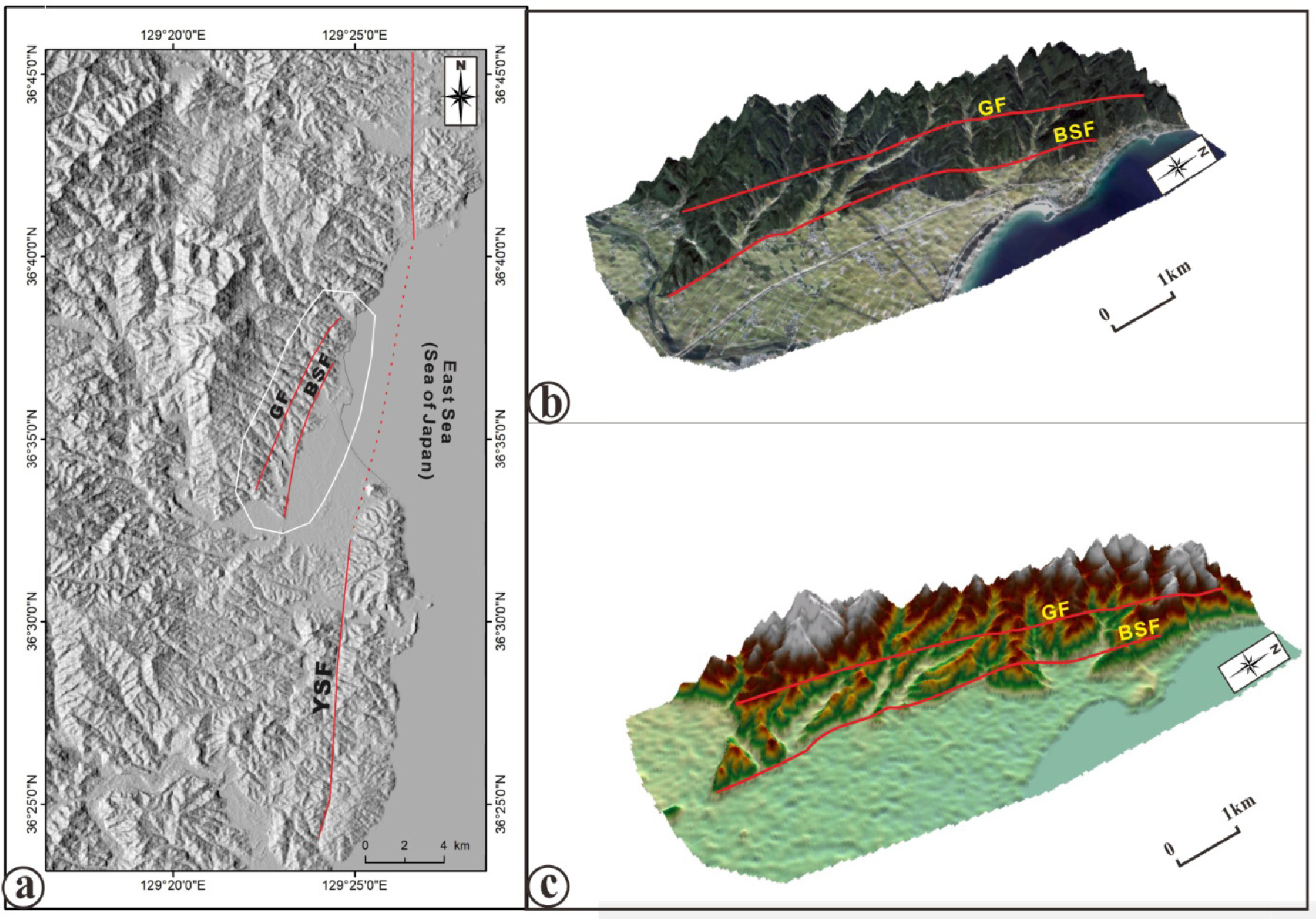
Yangsan Fault (YSF)
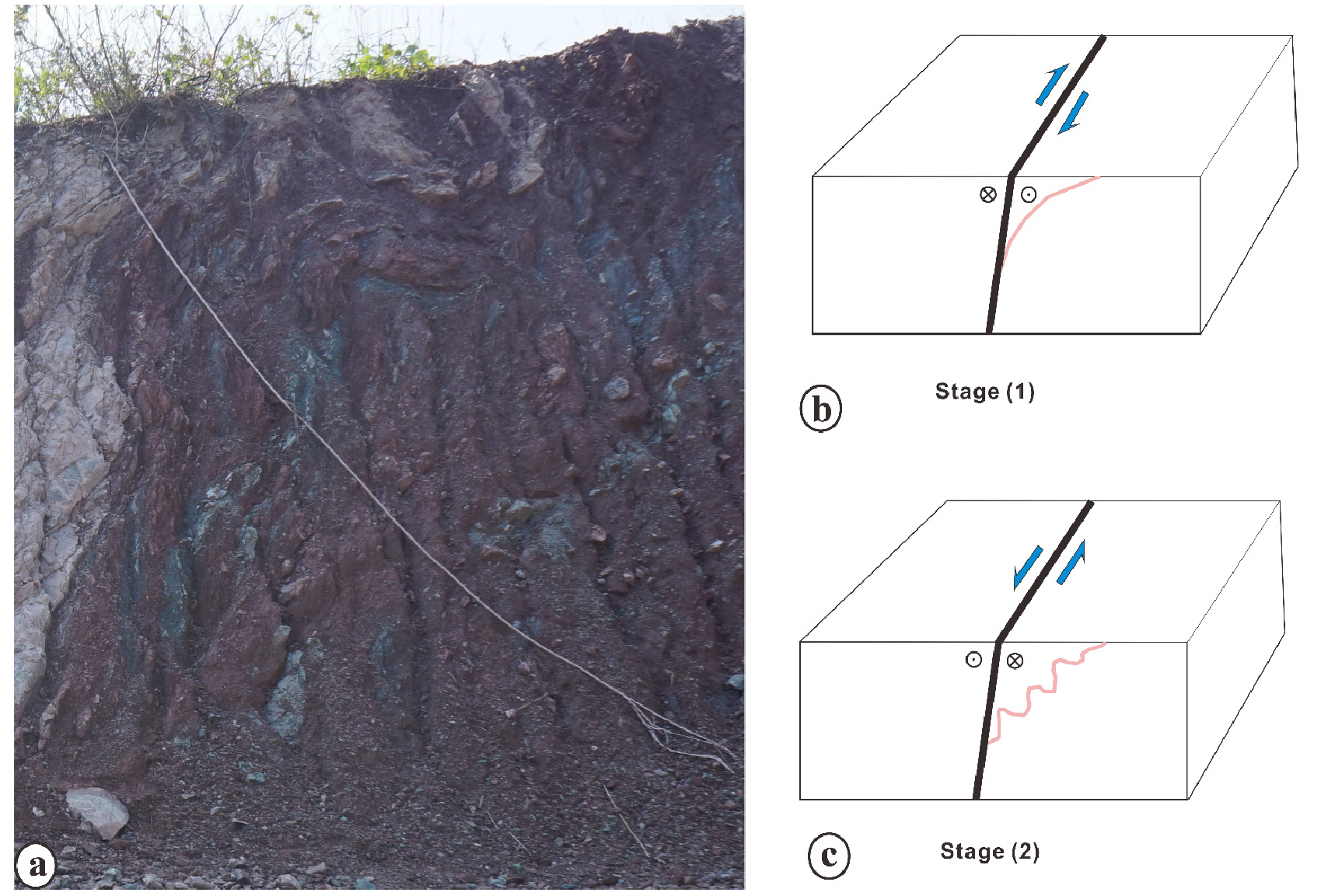
It is characterized by clear linear topographic expression in the DEM map (Fig. 3). Generally, the fault strikes in the N-S direction and steeply dips toward the east. Consistently with the previous studies, the kinematic indicators along the YSF indicate that the fault has experienced multiple deformation events through geological time. Fig. 4 shows field photographs of the YSF fault core outcrop at a construction site located near the Gogok village (Fig. 4a). The fault is striking in N-S direction and dipping 64°E. The fault zone consists of a fault core and two damages zones; east and west of the fault core. Both are hosted in the Cretaceous sedimentary rocks. The fault core consists of alternated brecciate and gouge zones (Fig. 4b). The measurable width of the fault core is about 4.8 m. Several gouge bands with various colors (black, gray, and reddish-brown) are observed (lower-left corner of Fig. 4b). The rose diagram in the lower right corner of Fig. 4b shows the trend of gouge bands. Slickenlines are recognized in the fault plane. The trend and plunge of the slickenlines is 017°/09° (Fig. 4c). Lens-shaped fragments are founded as a result of shearing in the fault damage zones, indicating left-lateral movement (Fig. 4d, e, f). Fig. 5 shows field photographs of a refolded drag fold of the Cretaceous sedimentary rocks in the YSF damage zone. The fold formed as a drag fold, related to a normal component associated with the right-lateral strike-slip movement (Fig. 5b). Later on, the drag fold was subjected to a reverse component, which led to the refolding due to the reactivation of the YSF as a left-lateral strike-slip fault (Fig. 5c).
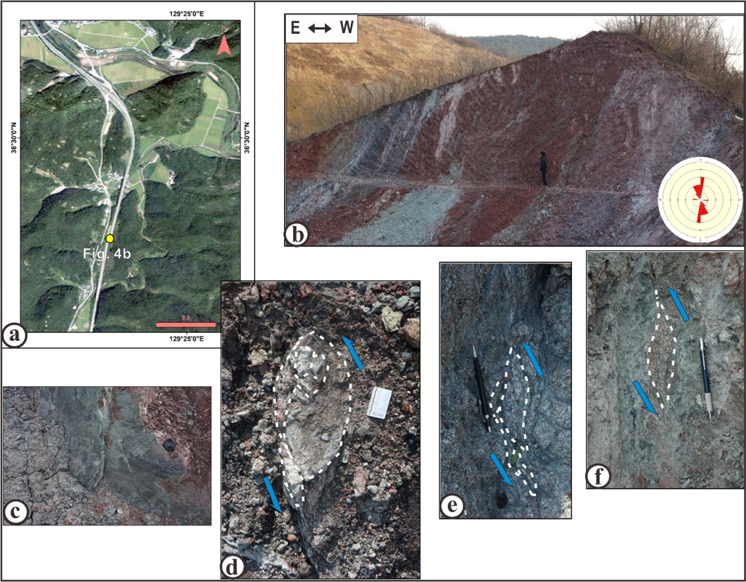
Fig. 4.
Field photographs of the Yangsan fault (YSF) exposed in a construction site near the Gogok-ri. (a) Satellite map showing the outcrop location (yellow circle). (b) A full view of the outcrop showing the fault zone. The rose diagram in the lower right corner of the photograph shows the trend of gouge foliation. (c) Slickenlines from the fault zone. (d), (e) and (f) Lens-shaped fragments indicating left-lateral strike-slip movements along the fault.
Baekseokri Fault (BSF)
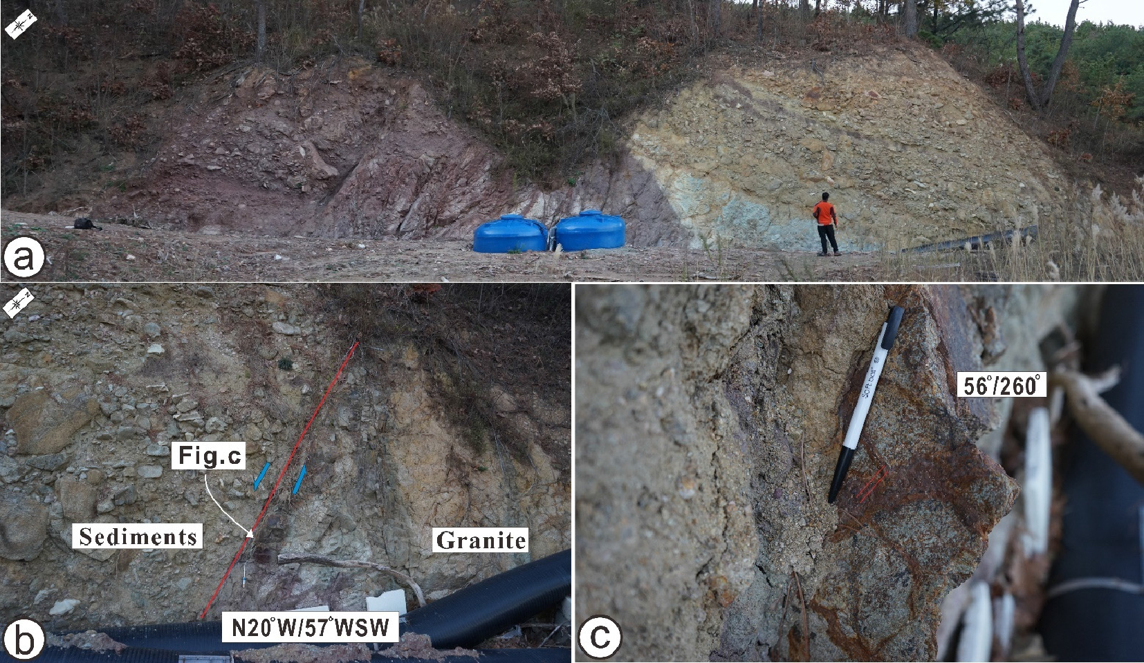
The sudden change in the morphology and the distribution of the Tertiary sedimentary rocks leads to recognizing the BSF along the western margin of the Yeonghae basin. This fault splays from the northern segment of the YSF and is characterized by curvilinear topographic expression in the DEM map (Fig. 3). The kinematic indicators along BSF indicate that this fault is characterized by an oblique right-lateral strike-slip movement. Some defracted valleys support the existence of the fault and the right-lateral sense of movement. Fig. 7 shows an outcrop of the BSF observed in the northwest corner of the basin, near Baekseok village. The outcrop consists of sedimentary rocks unconformably overlain the Tertiary granite, and both are affected by the BSF (Fig. 7a, b). In this outcrop, the fault strikes N20°W and dips 57°W. Slickenlines are observed on the fault surface, indicating an oblique slip. The trend and plunge of the slickenlines are 260°/56° (Fig. 7c). The measurable fault damage zone is about 100 m.
The BSF and GF display a sub-parallel branch pattern (Fig. 3a). Thus, the basin developed between the YSF and the BSF can be considered as a wing crack type opening at the southern tip of the northern segment along the YSF or as an extensional structure associated with the opening of the East Sea.
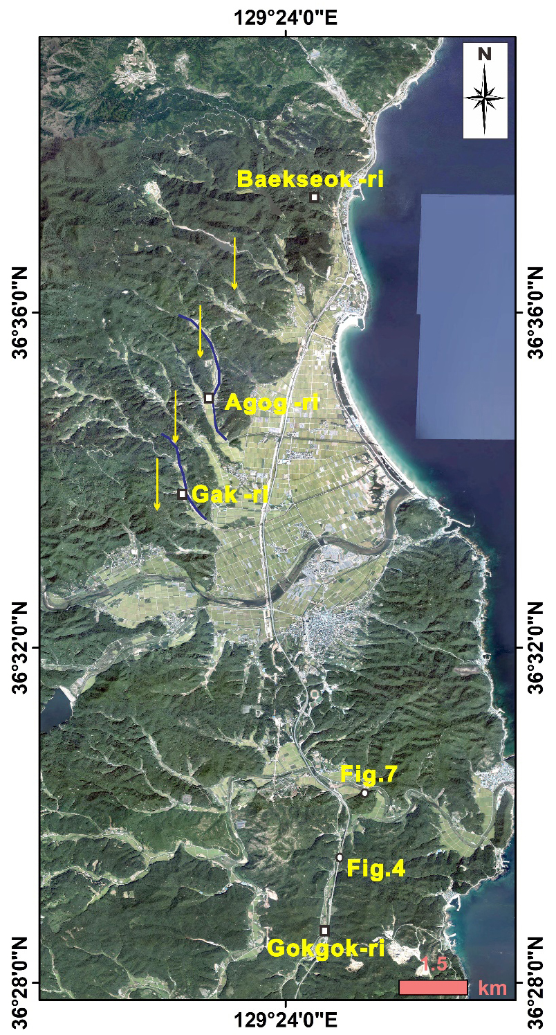
Gakri Fault (GF):
This fault has topographic expression and can be detected for more than 10 km in the DEM map (Fig. 3). Generally, the GF strikes N41° E and dips 53° SE. The kinematic indicators along GF show that this fault is characterized by oblique right-lateral strike-slip movement (right-lateral strike-slip movement associated with a reverse component).
Fig. 6 shows the GF caused a right-lateral bending of the Gakri stream (GST) and Agog stream (AGST) for more than 1.2 km and 1.7 km, respectively. Fig. 8 shows field photographs of the kinematic indicators from the GF outcrops. Fig. 8a shows slickenlines well preserved on the fault surface of one of the major faults strands of the GF zone, located west of Gakri village. The fault strikes N41° E and dips 53° SE. The trend and plunge of the slickenlines is about 041°/69°. The stepping of the slickenlines indicates an oblique right-lateral strike-slip movement of the GF.
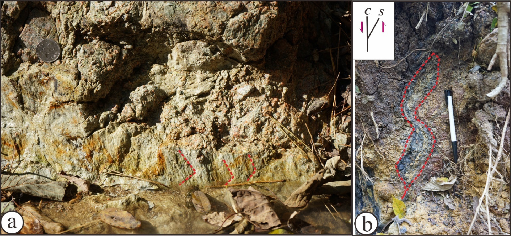
Fig. 8b shows field photographs of the S-C fabric of the fault gouge from the outcrop of the GF zone, located west of Agog village. The S-C fabric indicates a reverse component of GF. The fault width is variable along the fault. The measurable width is more than 300 m, west of Gakri village.
Intra-Basinal Structures
Orientation data of the structural elements, beddings, dikes, faults, and joints, have been collected to construct the architecture of the intra-basinal structures. The collected data reveals that the dominant trend of the structural elements in the study area is NE-SW (Fig. 9).

Beddings
The major units of the sedimentary rocks in the study area are the Cretaceous sedimentary rocks and the Tertiary sedimentary rocks. Based on the collected data of the bedding, the Cretaceous sedimentary beds along the eastern margin are striking in NNW and dipping toward the WSW (20~80°). While along the western margin, the beds are striking in NNE to ENE and dipping toward the ESE to SSE (10~70°). The contrary dipping direction of the Cretaceous sedimentary rocks is reported in the other places in the Gyeongsang basin. This phenomenon could be related to basin-scale folding or block rotation accompanying faulting (Kim and Park, 2006), which is also could be related to the inverted process of the basin. The Tertiary sedimentary rocks along the southern margin are striking in NNE and dipping toward the WNW with low angle (8~10°) (Fig. 9a, b). Whereas along the western margin it distributed as alluvial fans controlled by BSF (Fig. 2).
Dikes
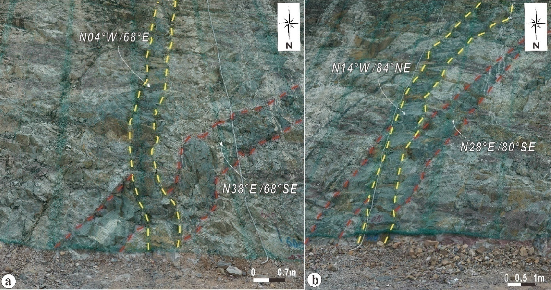
Dikes in the study area can be classified into acidic, intermediate, and basic dikes. The collected field data shows a large scattering of dike orientation (Fig. 9c, d). The directions of dikes are dominantly in NNE-SSW and NE-SW. Most of the dikes cut through the Bulguksa granite, orienting in E to ENE. The crosscutting relationships show that the NNW-SSE to N-S dikes are relatively younger than the NNE-SSW dikes (Fig. 10). Dike orientations can be used as a tectonic extension indicator (Anderson, 1951), indicating perpendicular direction to the regional σ3 direction (e.g. Anderson, 1951). The emplacement of NNW-SSE dikes could be related to regional compressional stress in NNW-SSE direction, consistent with a left-lateral movement of the YSF. However, the dominant set of the dikes is NNE to NE direction, indicating the NNE to NE was the maximum horizontal compression stress direction at a stage. This suggested that the movement of the marginal faults in the study area was mainly controlled by the NNE to NE compressional stress regime at a stage, which is consistent with the a right-lateral movement of the YSF system.
Faults
Various types of faults with variable size are observed in the study area. The main faults in the study area are strike-slip faults, trending in N-S to NNE, which is a similar direction to the YSFS. The collected data from the study area show a large scattering of orientation, but the dominant sets are; NE-SW, N-S, ENE-WSW (Fig. 9e, f). The statistical analysis shows that the dextral strike-slip faults are striking in NW-SE and NNE-SSW, whereas the sinistral strike-slip faults are striking in NNW-SSE, N-S, and ENE-WSW. The dip-slip faults are striking in NNE-SSW, ENE-WSW, and ESE-WNW.
Joints
Joints are generally interpreted as structures formed by brittle failure associated with regional stress (e.g. Engelder, 1987; Dunne and Hancock, 1994) or as secondary structures associated with larger-scale faulting or folding (e.g. Hancock, 1985; Dunne and Hancock, 1994). Joints in the study area show a large scattering of orientation (Fig. 9g, h). In general, the dominant joint sets are trending in NNE-SSW and ENE-WSW. The main intersection points of the joints plunge moderately to the WNW (291°/81°) (Fig. 9g, h).
Joints are commonly formed perpendicular to the minimum compressive stress or as conjugate sets bisected by the maximum compressive stress (e.g. Brace and Bombolakis, 1963; Granier, 1985). Therefore, NNE-SSW and ENE-WSW could be the direction of the maximum compressive stress. This supports the postulated interpretation that the marginal faults were controlled by a maximum compressive palaeostress in NNE to NE direction at a stage (Fig. 9g).
Although the geometry of the study area is consistent with the definition of the strike-slip basin but the nature of the bounded faults and the statistical analysis of the intra-basinal faults illustrates that the study area represents a contraction zone rather than an extension zone (Fig. 11). Accordingly, the study area is push-up instead of pulling down in the present time. This suggested that the bounded faults reactivated oppositely due to the change in the stress direction as evidenced by the stress indicators.
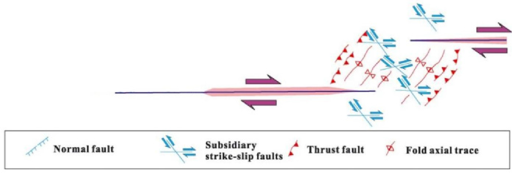
Fig. 11.
Fractures and deformation structures around the contractional overstep zones (modified after Sibson, 1986; Stewart and Hancock, 1994; Kim and Park, 2006).
Opening Mechanism of the Yeonghae basin
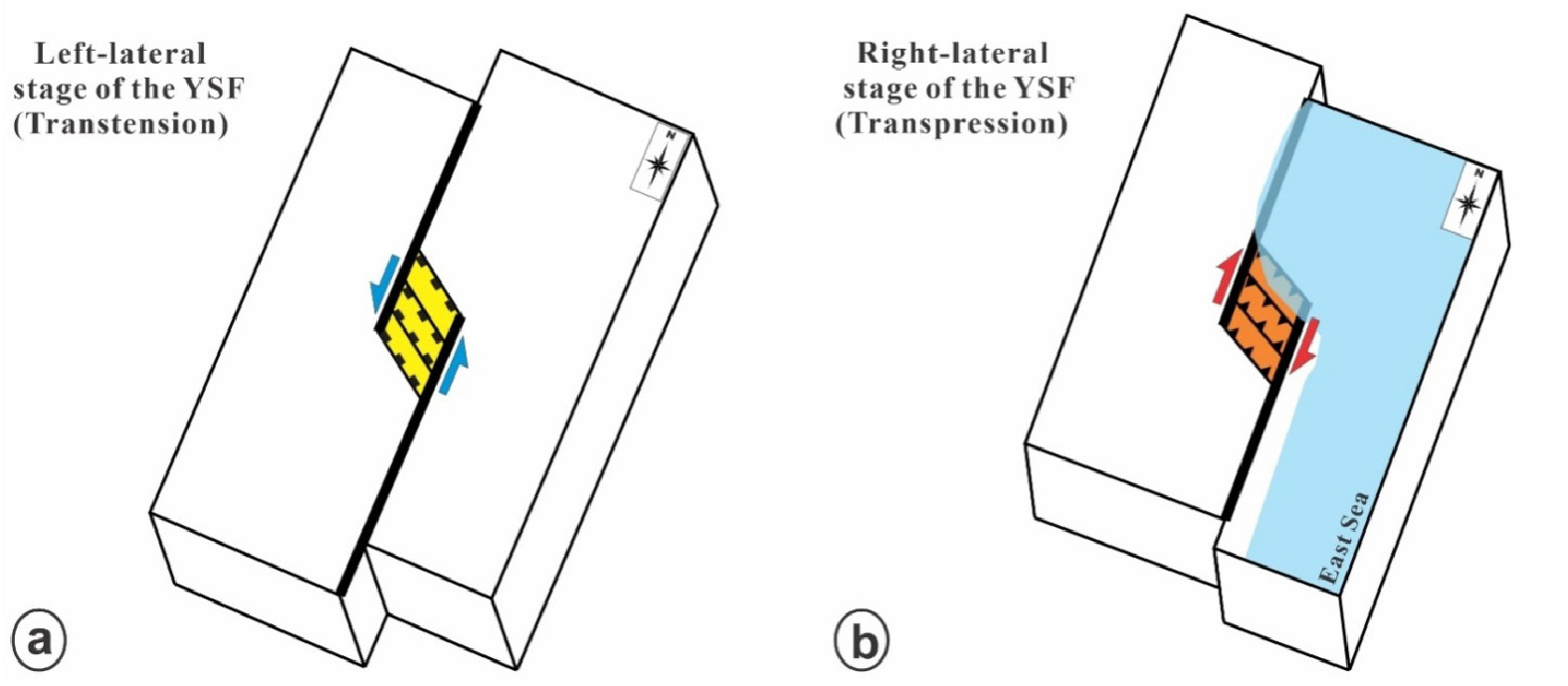
Based on the architecture of the intra-basinal structural elements, and the nature of the marginal faults, we suggest two models for interpreting the opening mechanism of the Yeonghae basin; the fault step-over model and the fault propagation model.
Fault step-over model
Based on this model, the Yeonghae basin developed as an extensional pull-apart zone due to the left-lateral step-over of the YSF (Fig. 12a). The left-lateral movement of the YSF was related to the NNW-SSE compression stress regime. Later on, the basin underwent regional extension in the ENE-WSW direction, related to the opening of the East Sea, as a result, a half-graben was formed controlled by the YSF and the BSF. Consequently, due to the Quaternary right-lateral movement of the YSF in the study area, the geometry of the Yeonghae basin is distorted and the basin began to inverted (Fig. 12b). This model is well-matched with the previous studies in a half-graben stage and the traditional concepts (Son, 1998). However, the collected structural data do not show much clear evidence associated with left-lateral movement. Also, the western boundary fault is smaller compared with the eastern boundary fault and the two boundary faults are sub-parallel to each other.
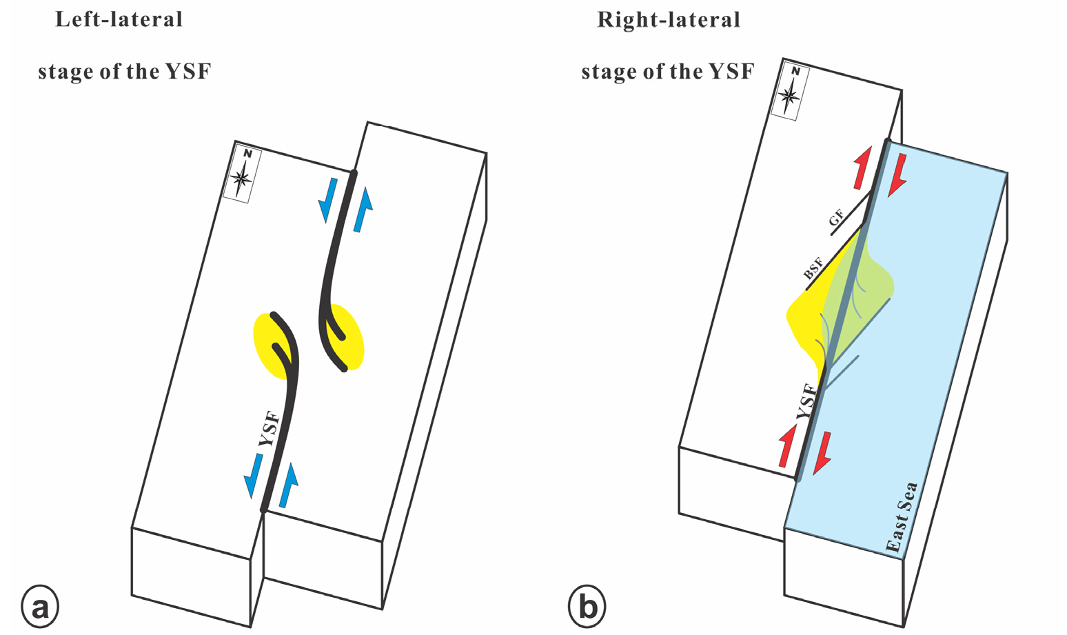
Fault propagation model
According to this model, the basin was initially developed as a small wing crack type opening or extensional zone at an old tip of the northern segment of the YSF. The YSF segments developed as strike-slip faults with left-lateral sense accumulating a relatively small displacement in the study area during the early stage (Fig. 13a). Later on, the fault segments were linked as a fault with the right-lateral sense (Fig. 13b). However, because the YSF is dominant in the right-lateral sense, a wing crack type opening or extensional zone was also developed along the secondary normal faults at the segment tip as a result of the accumulated right-lateral displacement at the linking zone of the two segments (Fig. 13b). This is supported by the pre-dominant NE-SW trend of the structural elements in the study area (Fig. 9). This model is well consistent with the dominant right-lateral movement of the YSF compared with the left-lateral movement and the western smaller and sub-parallel branching faults. This assumption is also consistent with the structural data and the large offset of the YSF in the study area which is estimated to be about 35 km (Chang et al., 1990).
Conclusion
The Yeonghae basin is developed along the Yangsan fault zone, a potentially active strike-slip fault, characterized by a dominantly right-lateral strike-slip movement in the present stress regime. The western marginal faults, the BSF and GF, are sub-parallel branching splay faults to the YSF and are characterized by an oblique right-lateral strike-slip movement.
The collected orientation data of the structural elements show a large scattering of orientation. However, the NE-SW is the dominant direction, indicating dominant right-lateral movement.
The kinematic indicators show that the maximum compressional stress direction was in NNE to NE and NNW-SSE, which is consistent with the right-lateral and left-lateral movements of the YSF system, respectively. However, the dominant direction of the structural elements in NE-SW suggests that the right-lateral movement of the YSFS is dominant compared with the left-lateral movement in the study area.
According to the architecture of the structural elements in the study area, we proposed two opening mechanisms for the Yeonghae basin; the pull-apart mechanism, due to the left-lateral movement of the YSF, and a wing crack type opening mechanism due to the right-lateral movement of the YSF. Although it is hard to determine a proper mechanism based on the present data, the characteristics of the major boundary faults around the basin and the predominant NE-SW trend of the structural elements in the study area are well matched with the predominant right-lateral movement along the YSF and force us to prefer the fault propagation model.
