

Introduction
Geological setting and field investigation of the study area
Regional geology
Field investigation and sampling
Laboratory tests
Modal analysis
XRD analysis
Physical property tests
Particle size distribution test
XRF analysis
Slake durability test
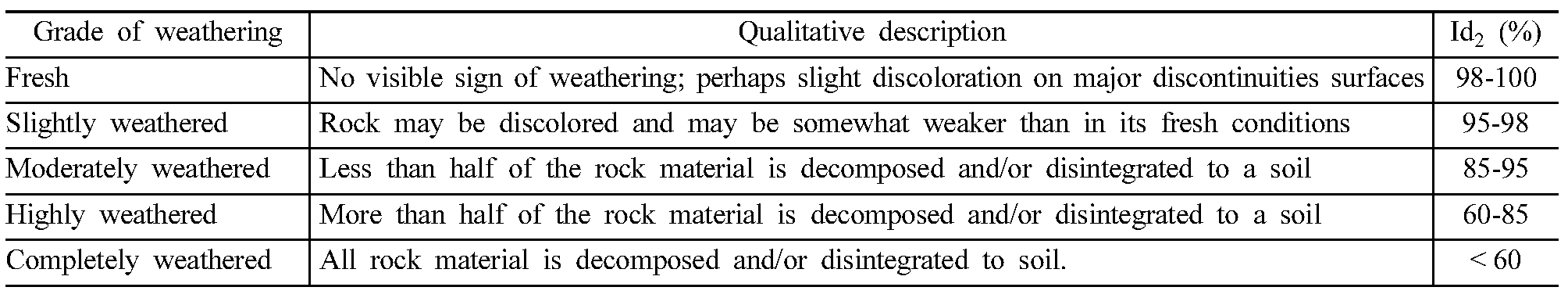
Weathering index
Chemical weathering index
Slake durability index
Discussion
Analysis of weathering mechanisms based on the results of laboratory tests
Comparison with previous studies
Conclusions
Introduction
The weathering process is sub-divided into physical weathering, in which rocks are physically broken by external forces, and chemical weathering, in which rocks are chemically decomposed or altered. Physical weathering is caused mainly by discontinuity, pores, and micro-cracks within the rock, while chemical weathering is a result of reactions between the chemical elements that make up the rock and fluids that come into contact with the rock. Ongoing physical or chemical weathering at the surface or underground reduces the strength of surrounding rocks by reducing their coherence and cohesion. Rocks exposed during excavation work for the construction of roads and tunnels show great variation in their physical, chemical and engineering characteristics depending on their grade of weathering. In particular, granitic weathered soil, which is the residual soil resulting from the weathering of granitic rocks, appears to be strong and highly cohesive when observed with the naked eyes; however, it can be easily destroyed by external impacts, such as hammer blows and sampling. In addition, rainfall on slope faces that are composed of granitic weathered soil can cause displacement by removing soil particles from the slope face or by penetrating the slope and thereby increasing the pore pressure between soil particles. Soil particles removed in this way are transported by rainwater flowing along the slope surface and lead to rill erosion. When such erosion occurs for a period of time, large amounts of soil may be lost, resulting in slope failure (JGS, 1995).
In a study on the erosion or failure of a slope induced by rainfall, Bryan (2000) examined the possibility of soil erosion and erosion mechanisms by water on hillslopes. Bryan argued that the soil properties affected by weather and climate determine the erosion potential and that the flow of water due to rainfall or ground runoff causes rill erosion. Ha (2007) investigated the types of slope failure caused by rainfall, and studied reinforcement methods that consider different types of erosion, such as rill erosion or surface loss. He reported that to prevent slope failure during rainfall, drainage on the inside and outside of slope is the most important factor, and recommended horizontal drainage, lateral ditches along the berm, and drainage canals as methods of reinforcement. He also proposed the use of re-vegetation technologies suitable for slopes consisting of granitic weathered soil, where vegetation of the slope is typically difficult, such as a combined method of soil covering and the addition of green soil. Shen et al. (2015) simulated rainfall on artificial slope at rates of 50 and 100 mm per hour, repeated three times at intervals of 24 hours to study the morphology of the initiation of rill erosion and the shape of rill erosion. The size, depth, and width of rills were determined by the intensity of the artificial rainfall, and the amounts of soil washed away were proportional to the intensity. Guerra et al. (2017) studied the effects of rainfall, soil properties, geomorphology, and vegetation on the washing away of soil and landslides. They focused on cases in Brazil and the United Kingdom, and found that man-made changes to the geomorphology (e.g., slope cuttings) and natural erosion by water were the most influential factors.
To quantitatively evaluate the degree of chemical weathering of rocks, many researchers have proposed indices of chemical weathering, utilizing various chemical elements. Vogt (1927) proposed Vogt’s Residual Index (V), which is calculated from a geochemical analysis of completely weathered residual sediments. Since the V values are obtained by treating Al2O3, which has low mobility, as a numerator, larger V values indicate further progression of chemical weathering. Ruxton (1968) presented the Ruxton Ratio (R), obtained by calculating the ratio of SiO2, with relatively high mobility, to Al2O3, which has a low mobility. Parker (1970) performed chemical analysis on quartzose rocks containing alkali elements and proposed the Weathering Index of Parker (WIP) for these lithologies. Vogel (1973) published the Modified Weathering Potential Index (MWPI), a modified version of the Weathering Potential Index (Reichem 1943), where element as water (H2O) is removed from WPI. The MWPI defines the characteristics of weathered rocks in which the constituent materials (including SiO2) decrease relative to the components of the parent rock with continued weathering. Nesbitt and Young (1982) proposed the Chemical Index of Alteration (CIA), which is the most commonly used chemical weathering indexes. The CIA is based on the continuous alteration of plagioclase and kfeldspar into clay. High CIA values indicate that unstable elements (Ca, Na, K) in the weathered material have been mobilized. The Chemical Index Weathering (CIW), proposed by Harnois (1988), is a modified version of the CIA. The CIW does not consider K2O to account for the relocation of K ions when rocks are subjected to metamorphism and diagenesis. The Chemical Weathering Index (CWI) proposed by Sueoka (1988) is based on the chemical analysis of weathering-sensitive minerals, at the constituent components of these mineral (e.g., alkali, alkaline earth metals, and silicon dioxide) decrease relative to the components of the parent rock as weathering progresses.
In the present study, field investigations and laboratory tests were carried out on biotite granite and granitic weathered soil in the Gyeongju area, to identify their weathering properties. In addition, differences in the physical and chemical weathering properties were identified through comparison with the results of previous studies.
Geological setting and field investigation of the study area
Regional geology
The geology of the study area consists of Cetaceous biotite granite, black shale and red shale, and Quaternary alluvial deposits in valleys (Fig. 1). Shales of the Cretaceous Silla Group form the bedrocks, and consist of layers of black shale, red shale, hornfels, and sandstone. In addition, felsite, biotite granite, and rhyolitic quartz andesitic porphyry of the Bulguksa Intrusive Rocks, and andesitic porphyry and andesite of the Cretaceous Silla Group are widespread throughout the study area. Major geological structures in the region include the Ulsan Fault, which occurs ~2 km east of the study area, and Yangsan Fault, which occurs ~10 km west of the study area.
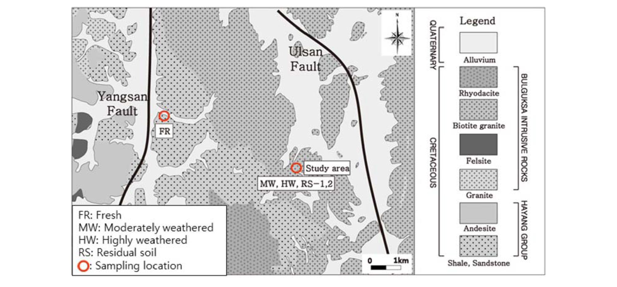
Fresh (FR), moderately weathered (MW), and highly weathered (HW) samples, as assessed by visual observation, were collected to identify the weathering properties of biotite granite in the Gyeongju area. The FR samples were collected from drill cores of a single rock mass at a distance of ~8 km from the study area while the MW and HW samples were collected from drill cores taken within the study area (Fig. 1). The soil samples RS-1 and RS-2 represent the residual soil (RS) and were collected using a ring sampler from slope faces in the study.
Field investigation and sampling
The slopes of study area, in which excavation of construction for tunnel are underway, include of back-side, left-side, and right-side slopes. The slopes are underlain by biotite granite that has been moderately weathered, and soils on the slopes are weathered soils. Multiple episodes of rill erosion have occurred throughout the slopes, and 10-cm-wide fault zones and intrusions of andesitic rock are observed. In addition, despite no rain falling during the field investigation, we observed water pathways that had formed by rill erosion and fine grains had been removed and deposited on the lower parts of the slope.
The back-side slope strikes N05°E and dip at 4 °NW; the slope is 30 m long and 20 m high (Fig. 2a). The upper left part of the slope was covered with a waterproof cloth to prevent excessive rill erosion. The moderately weathered granite in the lower part of the slope contains three sets of joints. A fault striking N30°W and dipping at 80°NE was identified in the lower left part of the slope. The fault width is 10 cm, and although the fault core is not well developed,it has propagated through to the left-side slope (Fig. 2b).
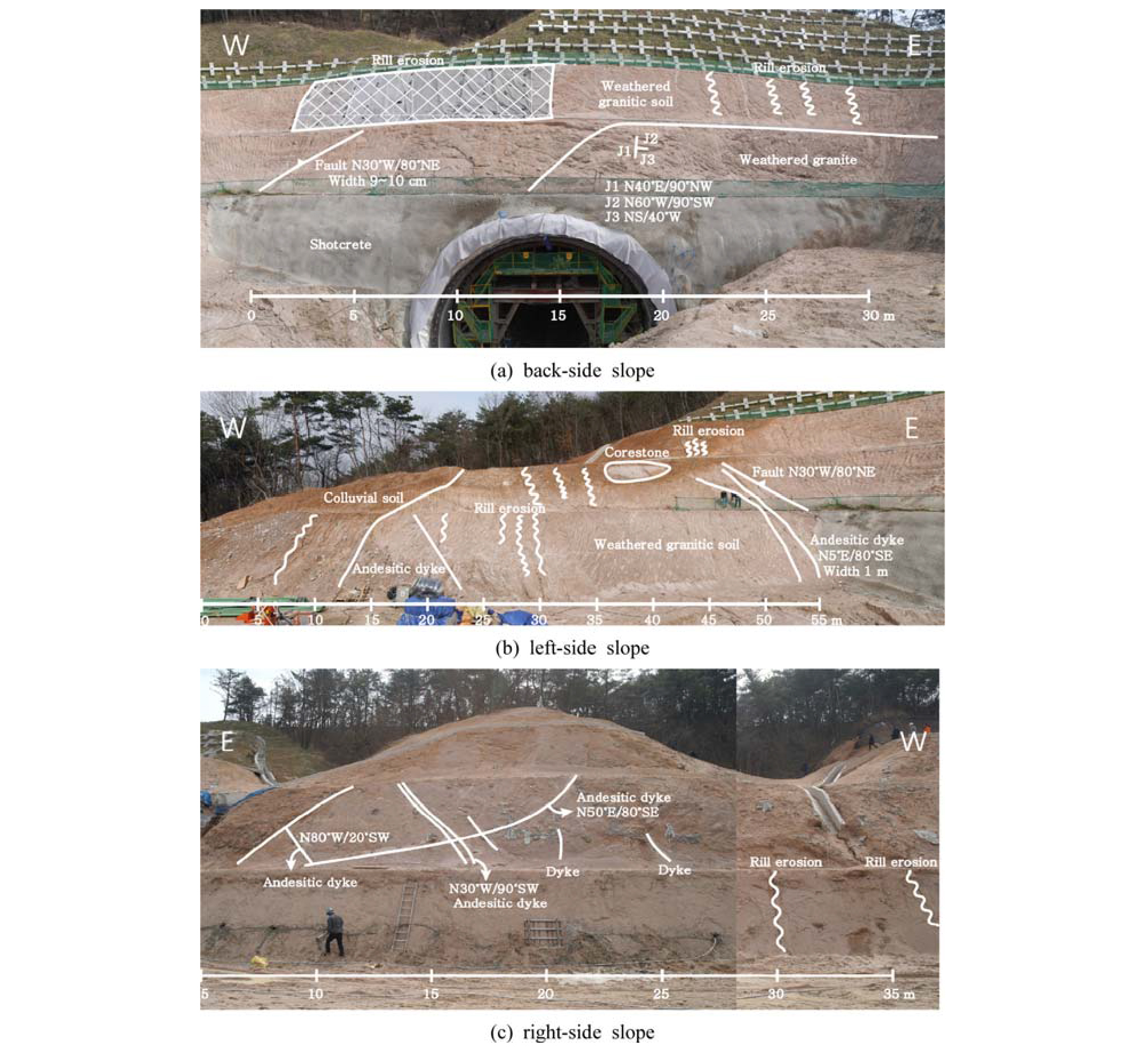
The left-side slope strikes N85°W and dips at 45°NE. The slope is 55 m long and 15 m high (Fig. 2b). The slope consists of highly weathered residual soils. Traces of rill erosion are commonly observed, and andesitic intrusions are again present. These intrusions are 1 m thick and are observed locally in the lower right part of the slope. At the center of the slope, a core stone, formed by the spheroidal weathering of granite, is observed with a major axis length of ~8 m.
The right-side slope strikes N85°W and dips at 45°SW. The slope is 35 m long and 25 m high (Fig. 2c). Numerous cross-cutting andesite dykes have intruded the slope and traces of soil loss and erosion are observed along a drainage canal. Fine grained material, lost during rill erosion, has been deposited at the bottom of the slope.
Laboratory tests
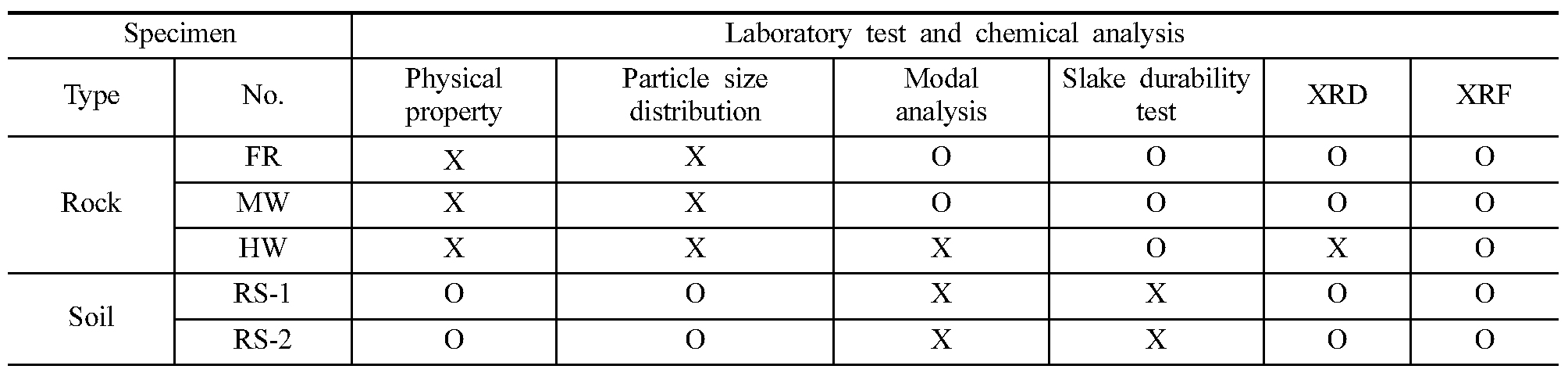
Modal, XRD, and XRF analysis, along with physical property tests, particle size distribution tests, and slake durability tests were carried out to determine the physical and chemical weathering properties of the biotite granite and granitic weathered soil in the study area. The samples were pre-treated by molding, powdering, or other methods, depending on the sample types (FR, MW, HW, RS-1, and RS-2), prior to testing or analysis. Table 1 lists the test or analyses applied to individual samples.
Modal analysis
Modal analysis is a method of measuring the mineral content ratios of rocks by obtaining the areas of distribution of minerals using the point counting method. The FR and MW samples, which are rock samples, were prepared as thin sections to conduct modal analyses by observation under a polarizing microscope.
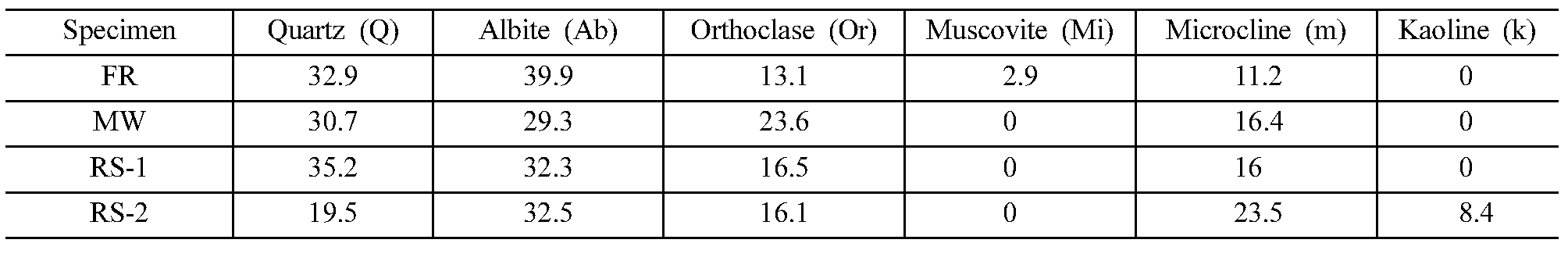
Based on these observation, the FR samples consist mainly of quartz, plagioclase, orthoclase, and microcline, with some biotite. These minerals are at least several millimeters in size, indicating that the rock is coarse-grained, the feldspars are heavily fractured and are more strongly weathered than quartz (Fig. 3a and 3b). The FR samples lack traces of alteration or later intrusions were not observed. According to the results of the modal analysis, the contents of quartz and feldspars (plagioclase, orthoclase, and microcline) accounted for 97.5% of all minerals (Table 2).
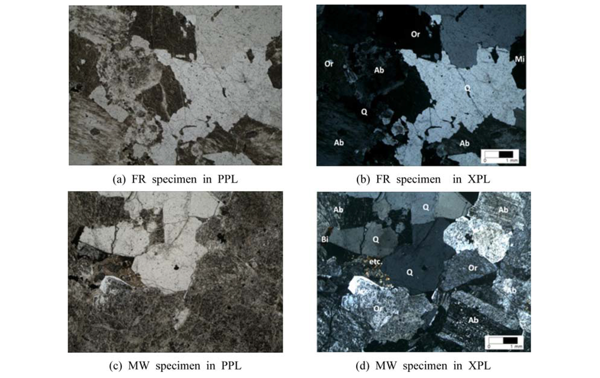

The MW samples contain similar constituent minerals to the FR samples. However, considerably more cracks were observed inside quartz grains compared with the FR samples, and plagioclase and orthoclase show traces of weathering (Fig. 3c and 3d). According to the modal analysis result, the MW samples contain slightly more plagioclase than quartz, and slightly less microcline than quartz (Table 2). The FR and MW samples are classified as biotite granites.
XRD analysis
X-ray diffraction is used to obtain crystallographic information for minerals by recording the diffraction of Xrays on regularly arranged lattice planes for atoms that are arranged periodically with three-dimensional regularity, which allows measurement of the distances between lattices. The X-ray diffraction method is applied to either single crystals or powdered samples. The single crystal method analyze the crystal structure of a single crystal, utilizing crystallographic information such as crystal axes, crystal systems, and space groups. The powder method is used to identify the substances of interest, qualitative analysis of minerals, analysis of phase changes according to temperature or pressure, changes in textures, and quantification of mineral contents when multiple substances are mixed. In this study, the powder method was used for obtain both qualitative and quantitative analyses.
The XRD analysis employed Ni-filtering CuKα (1.54056 Å) rays, with an accelerating voltage of 40 kV, current of 30 mA, and scanning time of 1 s at intervals of 0.02° in the range of 5° to 65°. Quantitative analysis utilizing the XRD results was conducted using a Siroquant program for the quantitatively calculation of minerals using the full analysis pattern.
The FR, MW, RS-1, and RS-2 samples were powdered for XRD analysis and the results are listed in Table 3. The combined contents of quartz and feldspars (plagioclase, orthoclase, microcline) were at least 90 wt.% in all samples, similar to the results of the modal analysis. Kaolinite, a secondary mineral produced by weathering, is only observed in RS-2 and is found in granitic weathered soil at a concentration of 8.4 wt.%.
Physical property tests
To determine the physical properties of the granite and granitic weathered soils in the study area, laboratory tests were conducted on samples RS-1 and RS-2 by applying the ASTM (ASTM D 2216-10) method to measure water contents in the soils, and the soil specific gravity test (ASTM D854-10). These physical property tests were conducted on six samples (three from RS-1 and three from RS-2) to determine the dry unit weights, specific gravity, water contents, and porosity (Table 4).
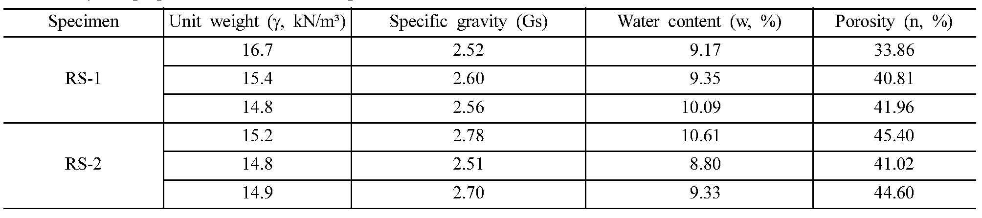
The dry unit weights of the granitic weathered soil range from 14.8 to 16.7 kN/m³, their specific gravity ranges from 2.52 to 2.78 Gs, water contents from 8.80 to 10.61%, and porosity from 33.86 to 45.40%. Mean values are as follows: dry unit weight 15.3 kN/m³, specific gravity 2.61 Gs, water content 9.56%, and porosity 41.28%. JGS (1995) reported the ranges of the physical properties of granitic weathered soils in general, as follows: natural water contents 2-10%, specific gravity of ~2.65 Gs, and porosity of 20-40% depending on the grade of weathering. The specific gravity and water contents of samples RS-1 and RS-2 fall within these range; however, the porosity is much higher than that reported by JGS (1995).
Particle size distribution test
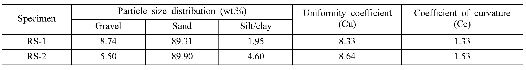
Particle size distribution analyses were carried out to classify the granitic weathered soils according to the Unified Soil Classification System (USCS) and to determine the particle size distribution and the component ratios of gravels, sand, and silt/clay. This analysis was conducted using the sieve-analysis test (ASTM D422-63).
The particle size distribution of RS-1 and RS-2 show that sand is the most abundant component with contents of at least 89 wt.%. In addition, the particle size is uniformly distributed, with uniformity coefficients (Cu) of at least 6, and curvature coefficients (Cc) in the range of 1 to 3. Therefore, RS-1 and RS-2 correspond to SW (Sand and Well graded) in the USCS. The granitic weathered soil samples of RS-1 and RS-2 show similar results each other and are listed in Table 5.
XRF analysis
X-ray fluorescence (XRF) is used to measure the secondary X-rays released from a sample owing to changes in the levels of the electronic energy of elements caused when empty sites form in the inner-shell electrons are released and filled by outer-shell electrons during irradiation. The secondary X-rays are called fluorescent Xrays and show an unique spectrum for each elements. Therefore, the analysis of these spectra allows the identification and quantification of elements.
The XRF instrument was set up with an RhKα X-ray target, and the an element analysis range from No. 4 Beryllium to No. 92 Uranium. A scintillation counter (SC) that can measure from No. 22 Titanium to No. 92 Uranium, and a flow proportional counter (FPC) that can measure from No. 4 Beryllium to No. 30 Zinc were used to measure fluorescence of the element.
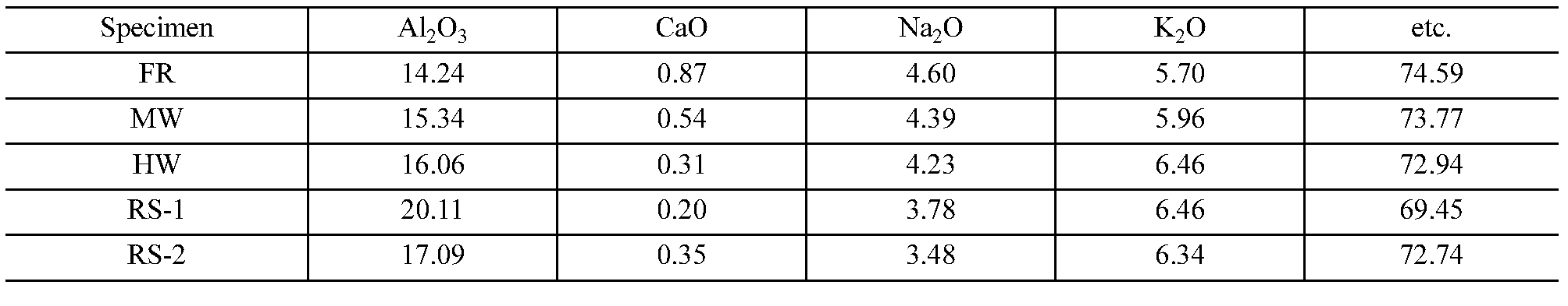
Prior to XRF analysis, all samples were dried and powdered. The results of these analyses are listed in Table 6. The contents of Al2O3 and K2O increase as weathering progresses from the FR sample to the RS samples, while the contents of CaO and Na2O decrease. These changes in content are attributed to the different mobility levels of elements leached by weathering.
Slake durability test
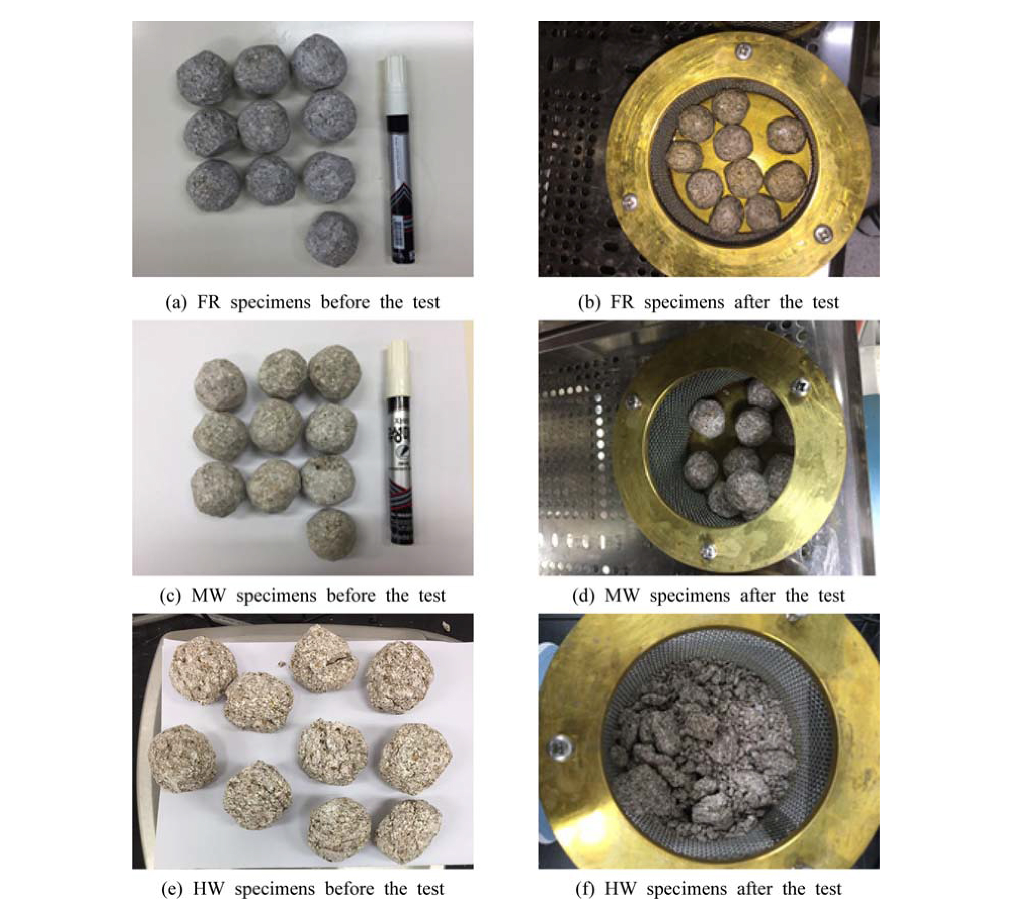
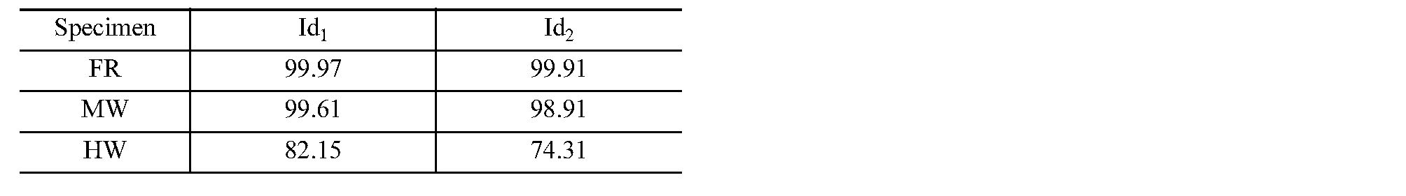
The slake durability test is an laboratory test carried out to determine the durability against physical weathering of rock. The degree of wear caused during the test is expressed as follows: (mass after test/mass before test) × 100 (%). Slake durability tests were carried out using the ASTM D 4644-04 test method. The samples were molded into a spherical shape, the mass of each sample was in the range of 40 to 60 g, and the total mass was distributed in the range of 450 to 550 g. The tests were conducted over 2-cycles.
The slake durability index (Id2) of the FR sample, which was hardly weathered, was 99.9%, that of the MW sample (98.9%), and that of the HW sample was 74.3%, indicating that weathered samples tend to have lower durability against physical weathering (Table 7). In addition, as can be seen from the photos of samples before and after the tests (Fig. 4), the HW sample did not maintain its spherical shape after the test, while the FR and MW samples showed no visually identifiable change in shape.
Weathering index
Chemical weathering index
The constituent elements of minerals within rocks are leached by progressive chemical weathering, and their mobility varies with the type and solubility of the leached elements. In general, alkali metals and alkaline earth metals are highly mobile, while TiO2, Al2O3, FeO, CaO, MgO, MnO, K2O, and Na2O are known to have lower mobility. The behavior of certain elements according to the degree of weathering can be seen by comparing the contents of highly mobile element species with those of less mobile elements in a rock sample. That is, as weathering progresses, elements with low mobility remain while elements with high mobility are leached out of the rock, meaning that the elemental contents of rocks before and after weathering are different.
Table 8 shows various chemical weathering indices. Among them, the CIA indicates changes in alkali elements compared with Al2O3, which has a low mobility. As chemical weathering progresses and elements are leached, Al2O3 remains in the rock because of its low mobility, while alkaline elements are easily lost, leading to an increase in the CIA values. In general, the CIA values of biotite and feldspar are ~50 while that of kaolinite, which is a clay mineral produced by weathering, is ~100. This shows that CIA values can reflect both primary minerals, which are rock-forming minerals, and secondary minerals, which are minerals that form during weathering. The CIA of fresh granite is ~50, and the CIA values of weathered granite become progressively higher.
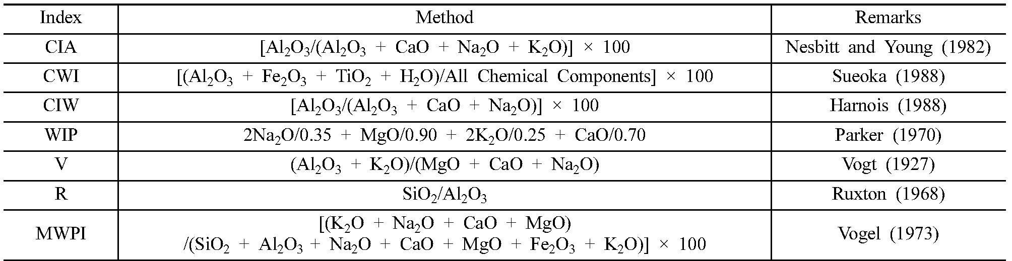
The CWI, introduced by Sueoka (1988), is based on chemical analyses of weathering-sensitive minerals, as weathered soils can be classified based on chemical changes in rock-forming minerals, as soils weathered from the same lithology may show different types or degrees of weathering depending on the weathering environment (Choo and Jeong, 2011). Since the CIW is a weathering index that rules out the formation and alteration of minerals by K ions, it has an advantage over the CIA by allowing the analysis of secondary minerals generated by weathering.
The WIP is based on the analysis of quartz rocks containing alkaline elements. This index may not be suitable for the analysis of highly weathered soils that have lost alkaline elements, as it relies on only the mobility of alkaline elements and alkaline earth metals. The V index (Vogt, 1927) is based on the geochemical analysis of weathered residual sediments. The V index is generally used for clay analysis, and it has been applied to moraine and marine clay (Roaldset, 1972). Since the granitic weathered soils in the study area contain traces of silt and clay, they are suitable for analysis using the V index. The Ruxton Ratio (R) is based on the assumption that when rocks are weathered, SiO2 is preferentially lost, while Al remains. Since the content of Al generally increases as weathering progresses in granite, the R value will decrease. The MWPI is based on the analysis of metamorphic volcanic rocks, and utilizes the major rock-forming elements. Generally, the MWPI value decreases as weathering progresses.
The results of seven chemical weathering indices are listed in Table 9. In general, as chemical weathering progresses, the quantities of SiO2, Na2O, and CaO decrease, while the quantities of Al2O3 and TiO2 increase. This leads to increased values of CIA, CWI, CIW, and V, and decreased values of WIP, R, and MWPI. However, WIP and MWPI, which should decrease with the progress of weathering, do not clearly show this trend. In the case of WIP, the value does not decrease even when weathering progresses, as inferred from the K2O content, which is the most influential element. In the case of the MWPI, the values of MW and HW differ by 0.06, as the HW sample contains a relatively high Fe2O3 content.
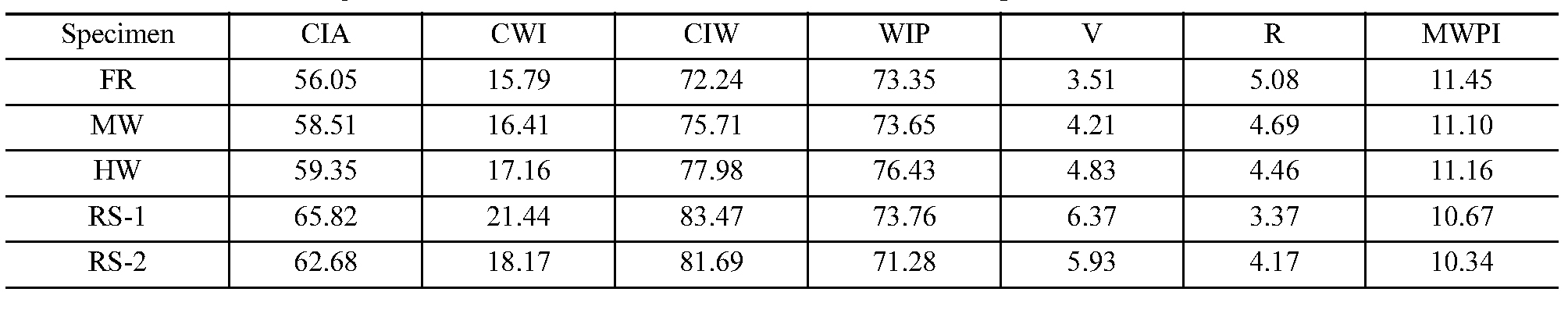
CWI values of 15-20 correspond to slight-moderate weathering, and values of 20-40 correspond to highcomplete weathering (Irfan and Dearman, 1978). The FR, MW, and HW samples from this study are classified as slightly-moderately weathered, but RS-1 and RS-2 samples are classified as highly weathered-completely weathered although they are colluvial soils. Choo and Jeong (2011) reported that most granitic weathered soils throughout Korea are completely weathered residual soils (CWI > 20).
Slake durability index
The grade of weathering according to the slake durability index presented by ISRM (1978) is classified into five grades ranging from fresh to complete weathering (Table 10). According to this scheme, the FR and MW samples are fresh rocks and the HW samples are highly weathered rocks. The MW samples were judged to be moderately weathered rocks during the field investigation, and they are classified as fresh rocks based on the slake durability index. The difference between the weathering grade proposed during in the field investigation and that estimated using the slake durability index is attributed to the fact that the minerals in the granite were only slightly altered by chemical weathering, as the granite had been at a depth of 20-30 m, but was recently exposed to the surface by excavation work.
Discussion
Analysis of weathering mechanisms based on the results of laboratory tests
The results of modal and XRD analyses indicate that the granite in the study area is biotite granite, and extremely small quantities of altered minerals are observed in granitic weathered soils, which represent residual soils. The results of the physical property analyses indicate that the porosity of the granitic weathered soils is higher than that of granitic weathered soils in general, and the particles that constitute the granitic weathered soil are mostly sandsized. In addition, the results of the chemical weathering index analysis show that chemical weathering was dominant over physical weathering. These results allow the weathering mechanism of the granite in the study area to be explained as follows.
The biotite granite parent rock was subjected to chemical weathering over geological time and secondary minerals were formed from feldspars, which are more easily weathered than other minerals and broke down to kaolinite (a clay mineral). Any fine-grained material from the parent rock, including clay minerals, has been lost because of the long-term effects of rain or ground water, and the loss of fine grains was accelerated as the porosity gradually increased. Consequently, most of the granitic weathered soil remains as sand composed of only quartz and feldspar. The slope faces made up of granitic weathered soil, which contain sand but almost no finegrained material, have become more vulnerable to soil erosion by rainwater because of the removal of vegetation and exposure to the surface during excavation work.
Comparison with previous studies
The weathering properties of granite were analyzed by comparing the results of previous studies on granite and granitic weathered soils with the results of this study. In previous studies, physical property tests, XRD analyses, and XRF analyses were performed on granites of ages ranging from the Precambrian to the Jurassic. The results of these studies were compared with the results of this study on the Cretaceous Gyeongju granite.
Han et al. (2008) collected granitic weathered soil samples, derived from a Cretaceous biotite granite, and conducted physical property tests, while Lee (1998) analyzed the physical properties of granitic weathered soil derived from a Jurassic-Cretaceous granite parent rock. The unit weight, specific gravity, and porosity of the granite analyzed by Han et al. (2008) were 16.8-16.9 kN/m³, 2.66-2.67 Gs, and 42.2-43.47%, respectively, which are within the range of values obtained for the Gyeongju granite, while the water contents were 11.4-13.7%, which differ slightly from those of the Gyeongju granite (Fig. 5a and 5b). The granitic weathered soil studied by Lee (1998) has water contents and porosity levels of 16.0-23.0% and 42.52-49.49%, respectively, which again differ from those of the Gyeongju granite. These comparisons indicate that granites formed at the same time show similar physical properties in their resultant granitic weathered soils, while granites formed at different times react to weathering differently because of changes in their constituent minerals, which also affects their porosity and water contents.
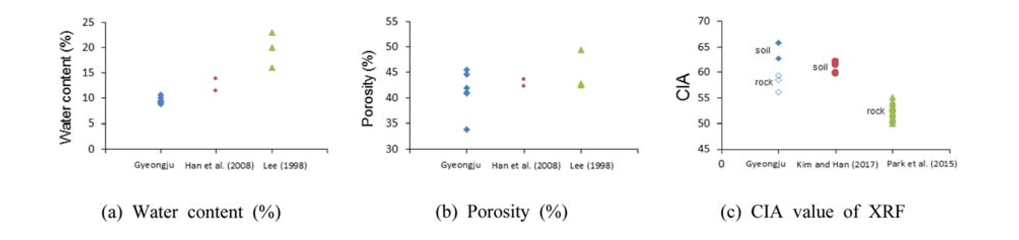
Previous studies using XRF analyses to calculate the chemical weathering index of a rock include Park et al. (2015), who studied a Jurassic granite, and Kim and Han (2017), who analyzed a granitic weathered soil from a Precambrian granitic gneiss parent rock. The CIA index was used to compare XRF results from the previous studies with those of the Gyeongju granite. The weathering grade of the Jurassic granite (Park et al., 2015) is classified as fresh, and the average CIA for 20 samples is 52.41. The CIA value of the Gyeongju granite, which is also classified as fresh, is slightly higher at 56.05. However, the granitic weathered soils analyzed by Kim and Han (2017) have an average CIA value of 61.33, which is lower than that of granitic weathered soils from the Gyeongju area (64.25). These results are attributed to the Ca ion contents in the rocks (Fig. 5c), as Ca ions are found mainly in amphibole and plagioclase among the rock-forming minerals of granite, and the contents of these minerals were lower in the granites of the Gyeongju area than in the rocks studied by Park et al. (2015). In addition, as chemical weathering progressed, amphibole and plagioclase crystals in the Gyeongju granites were altered to chlorite, epidote, and clay minerals. These altered minerals were washed away, together with other fine-grained material, through the porous granitic weathered soils. This in turn led to a reduction in the Ca ion content of the Gyeongju granitic weathered soils compared with those analyzed by Kim and Han (2017).
These results and comparisons show that even similar granites may exhibit different mineral compositions depending on their time of formation, and that these differences in mineral compositions lead to the formation of different weathering products as chemical weathering progresses.
Conclusions
To determine the physical and chemical properties of biotite granite and granitic weathered soils from the Gyeongju area, field investigations were first carried out. The rock and weathered soil samples collected from the study area were analyzed by modal analysis, XRD, XRF, physical property tests, and slake durability tests. According to the results of the field investigations, traces of rill erosion were commonly observed on those slope faces composed of granitic weathered soil, and fine-grained material had been washed away and deposited at the bottom of the slope faces. Although relict structures were observed in the granitic weathered soil, the strength of the soil was very low, meaning that it was easily damaged by small impacts and therefore vulnerable to physical and chemical weathering.
Modal and XRD analyses indicate that the parent rock was a biotite granite, and physical property tests and particle size distribution analysis indicate a porosity of 41.28% and a sand content of 90%, which are relatively high. The results of the XRF analysis and slake durability tests show that the CIA, CWI, CIW, and V values tend to increase with progressive weathering, while the R values decrease. When the weathering grades were classified using the CWI, samples RS-1 and RS-2 were shown to be have values of 18.17 to 21.44, which are somewhat low but consistent with the CWI values of other granitic weathered soils throughout South Korea. In terms of the physical weathering indices, the slope durability index (Id2) showed a tendency to continuously decrease as weathering progressed, and the MW samples are classified as fresh according to ISRM. This is attributed to the fact that only some minerals were altered by chemical weathering and the physical properties were not affected.
A review of the formation process of the granitic weathered soils from the Gyeongju area shows that the granite parent rock was subjected to chemical weathering over a long period of time, and as a result the feldspars broke down into clay minerals (e.g., kaolinite), fine grained particles (e.g., clay minerals) were washed away by rainwater or groundwater, and the porosity gradually increased, thereby accelerating this removal of fine-grained material. Finally, most of the granitic weathered soil that now remains is sand composed of only quartz and feldspar, meaning that the slope faces are vulnerable to erosion by rainfall.
These results provide important information for understanding the mechanical behavior of granite and granitic weathered soils, and will help to solve problems encountered during excavation work for construction.
