
-
Special Articles
-
Special Articles
-
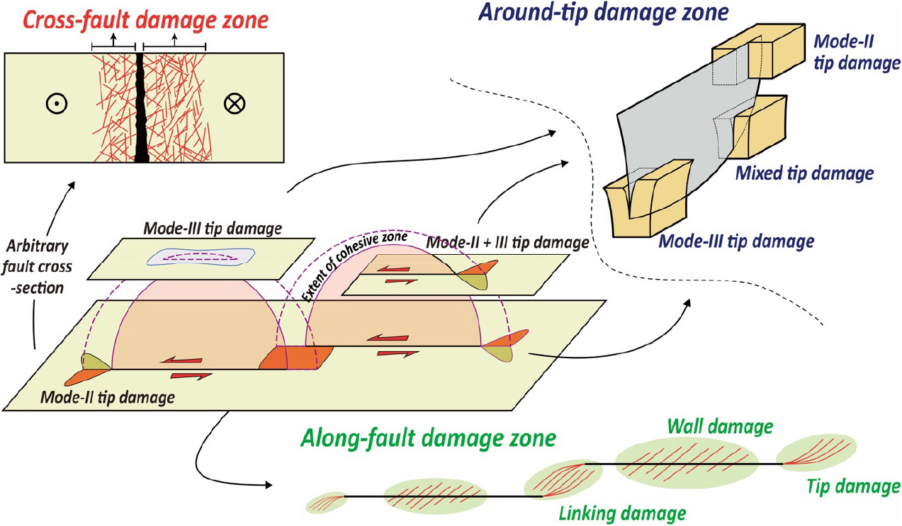
Quantitative Differences in Fracture Intensity and Connectivity along Different Types of Fault Damage Zone: A Case Study from a Strike-Slip Fault at Sinseondae, Geoje Island
단층손상대 유형에 따른 단열밀도 및 연결성의 정량적 차이: 거제도 신선대 주향이동단층의 예
-
Goeun Kim, Jinhyeon So, Sangyeol Bae, Young-Seog Kim
김고은, 소진현, 배상열, 김영석
-
Quantitative Differences in Fracture Intensity and Connectivity along Different Types of Fault Damage Zone: A Case Study from a Strike-Slip Fault at Sinseondae, Geoje Island
-
Special Articles
-
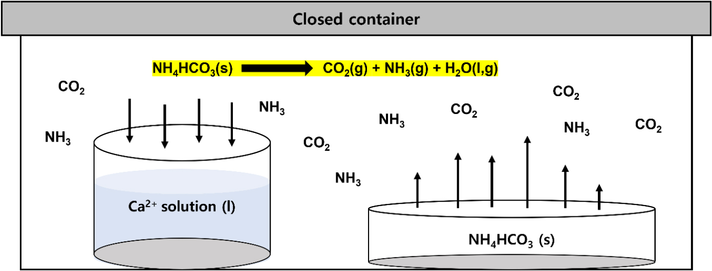
Temperature-Dependent Phase Selectivity and Morphology of Ammonia-Induced Calcium Carbonate (CaCO3) Polymorphs
암모니아 기체 확산법에서 탄산칼슘(CaCO3) 다형체 형태와 상 선택성의 온도 의존성
-
DongKwon Kim, Sugeun Jo, Jun Lim, YoungJae Kim
김동권, 조수근, 임 준, 김영재
-
Temperature-Dependent Phase Selectivity and Morphology of Ammonia-Induced Calcium Carbonate (CaCO3) Polymorphs
-
Special Articles
-
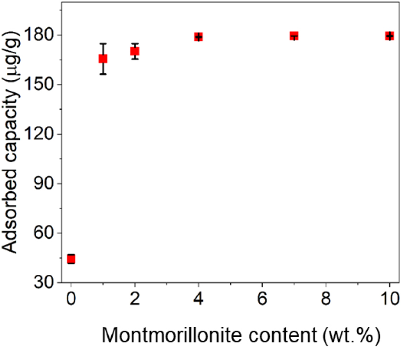
Characterization of Granular Montmorillonite–Polysulfone Adsorbent and Its Feasibility as a Passive Flux Meter for the Measurement of Groundwater Uranium Flux
지하수 우라늄 플럭스 측정을 위한 몬모릴로나이트–폴리설폰 입상 흡착제의 특성 규명과 플럭스미터 적용성 평가
-
Subeen Kim, Jimin Mun, Minjune Yang
김수빈, 문지민, 양민준
-
Characterization of Granular Montmorillonite–Polysulfone Adsorbent and Its Feasibility as a Passive Flux Meter for the Measurement of Groundwater Uranium Flux
-
Special Articles
-
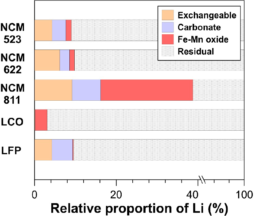
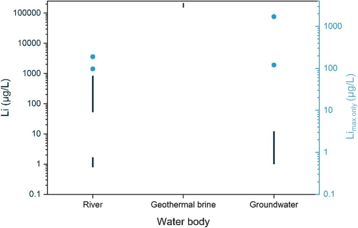
Characteristics of Lithium and Heavy Metals in Lithium-Ion Battery Cathode Materials
리튬이온배터리 양극재 내 리튬 및 중금속 분포 특성
-
Hyunjeong Kim, Hojin Park, Jiyeong Lee, Minjune Yang, Jong-Sik Ryu
김현정, 박호진, 이지영, 양민준, 류종식
-
Characteristics of Lithium and Heavy Metals in Lithium-Ion Battery Cathode Materials
-
Special Articles
-
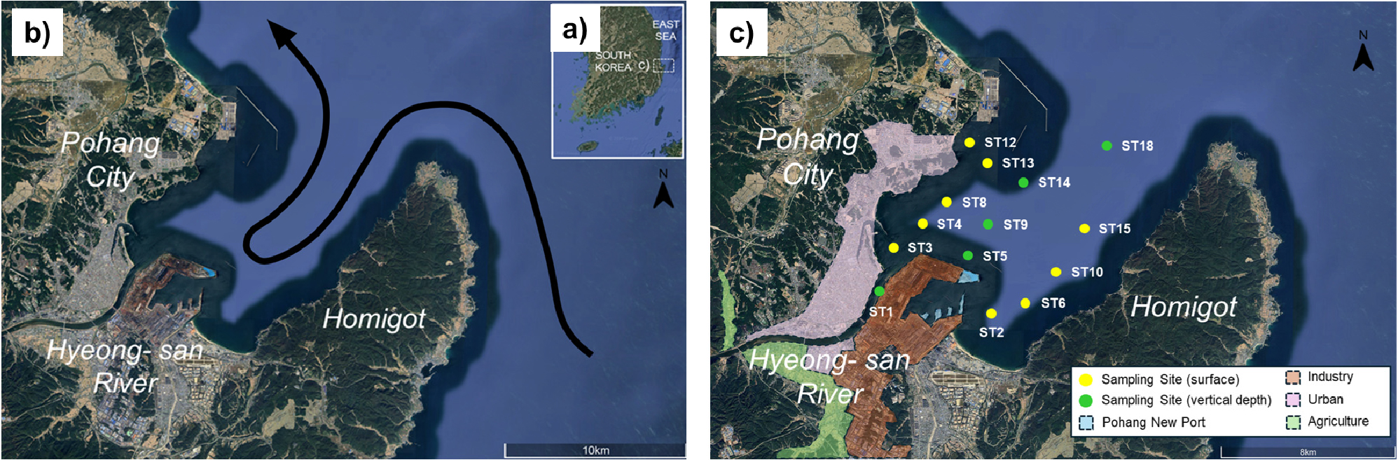
Spatial Variations in Natural and Anthropogenic Organic Matter Sources in Yeongil Bay: Application of a Bayesian Stable Isotope Mixing Model
영일만 내 자연적·인위적 유기물의 공간적 분포 특성: 베이지안 안정동위원소 혼합 모델 활용
-
Seung-Hee Kim, Gaeun Lee, Eunji Jeong, Sanggeun Lee, Hyojin Jeong, Sukjin Oh, Dong-Hun Lee
김승희, 이가은, 정은지, 이상균, 정효진, 오석진, 이동헌
-
Spatial Variations in Natural and Anthropogenic Organic Matter Sources in Yeongil Bay: Application of a Bayesian Stable Isotope Mixing Model
-
Special Articles
-
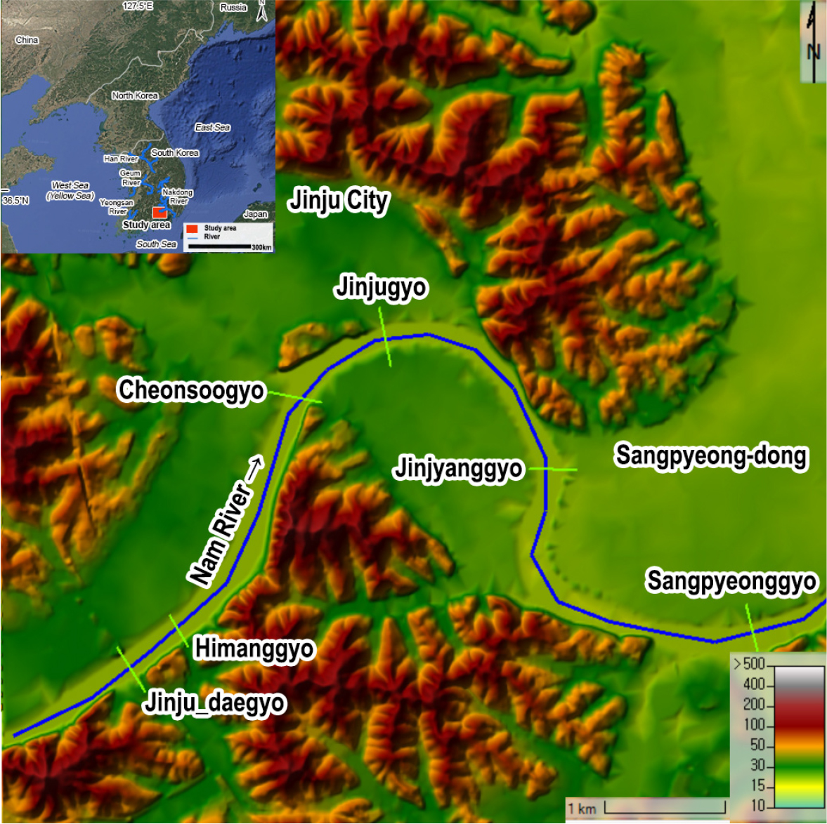
Spatial Relationships between Modern Flood Vulnerability and Historical River Levees Based on Hydrological Modeling: A Case Study of the Nam River (Jinju Daegyo–Sangpyeonggyo Reach, Korea)
수문모델링 기반 근대 하천제방과 현대 홍수 취약성의 공간적 관계: 남강 진주대교–상평교 구간 사례 연구
-
Jeongyun Kim, Soo Hyun Kim, Junghyung Ryu
김정윤, 김수현, 류중형
-
Spatial Relationships between Modern Flood Vulnerability and Historical River Levees Based on Hydrological Modeling: A Case Study of the Nam River (Jinju Daegyo–Sangpyeonggyo Reach, Korea)
-
Special Articles
-
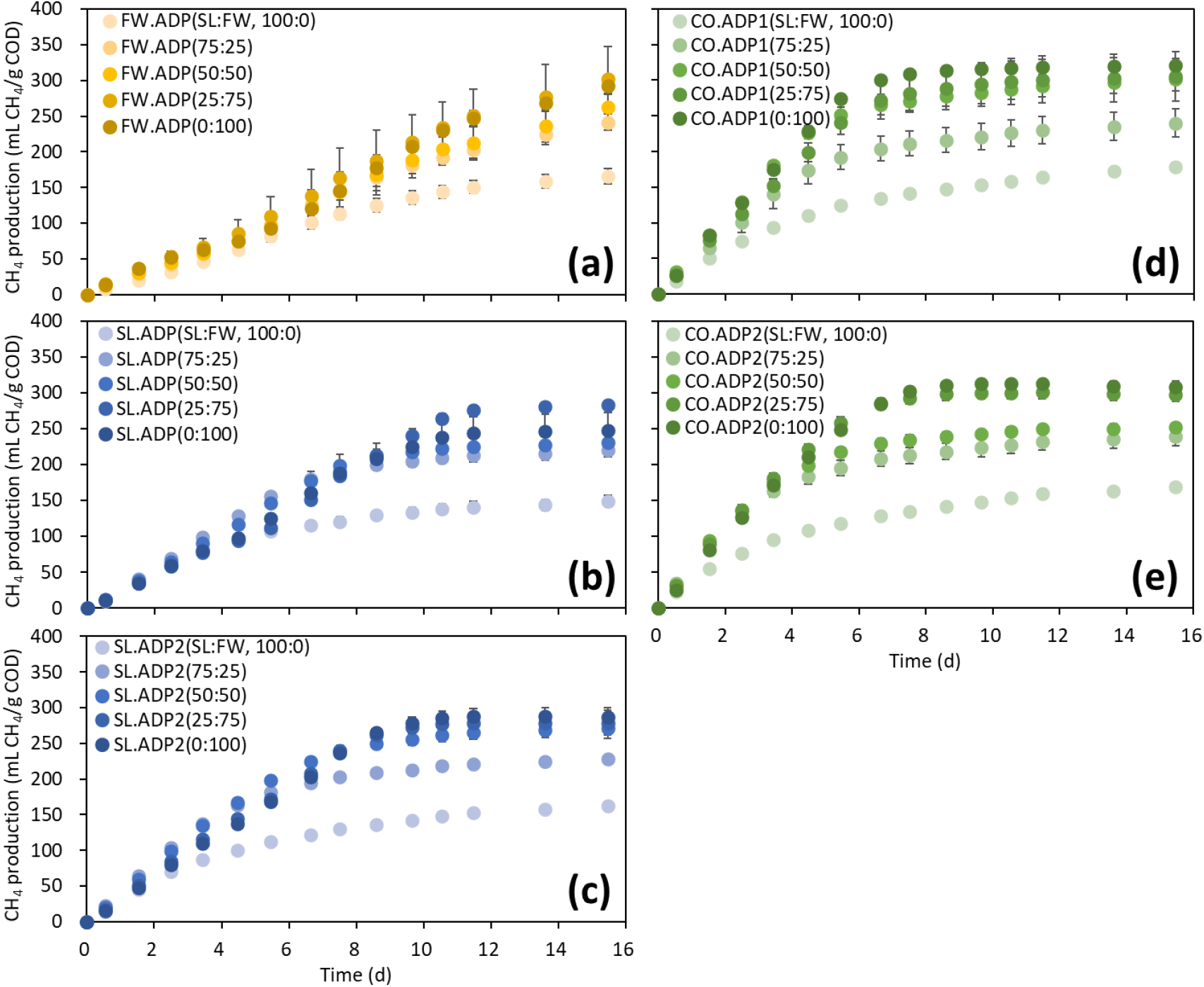
Effects of Feedstock Mixing Ratios and Inoculum Sources on Anaerobic Digestion of Sewage Sludge and Food Waste
기질 혼합비와 식종원 특성이 하수슬러지와 음식물류폐기물의 혐기성 소화에 미치는 영향 평가
-
Sungyun Jung, Se Eun Kim, Juhee Shin, Seung Gu Shin, Joonyeob Lee
정성윤, 김세은, 신주희, 신승구, 이준엽
-
Effects of Feedstock Mixing Ratios and Inoculum Sources on Anaerobic Digestion of Sewage Sludge and Food Waste
-
Special Articles
-
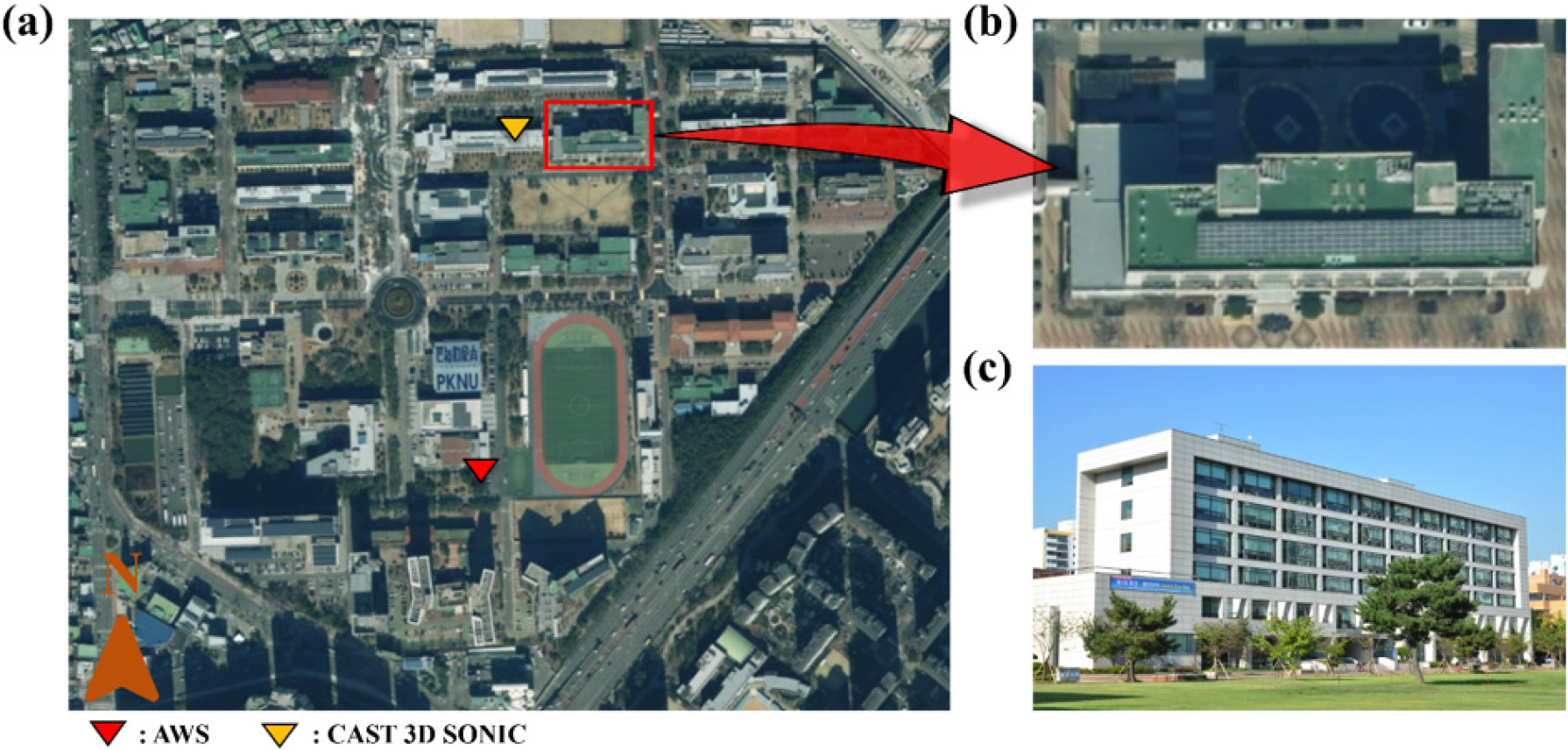
Prediction of Surface Temperature in an Urban Area Using a GIS-Based Energy Balance Model
GIS 기반 에너지 균형 모델을 이용한 도시 지역 표면 온도 예측 연구
-
Hyun-Ji Lee, Hyeon-Jong Lee, Dasom Mun, Dayeon Kim, Hwi-Rin Kim, Saeha Kim, Ye-Seung Do, Yun-Kyo Moon, Dong-Min Son, Seung-Hun Lee, Ah-Yeon Jeon, Yu-Rim Hwang, Jae-Jin Kim
이현지, 이현종, 문다솜, 김다연, 김새하, 김휘린, 도예승, 문윤교, 손동민, 이승훈, 전아연, 황유림, 김재진
-
Prediction of Surface Temperature in an Urban Area Using a GIS-Based Energy Balance Model
-
Special Articles
-
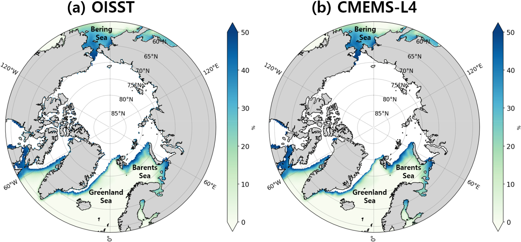
Comparison of Sea Surface Temperature and Sea Ice Concentration over the Arctic Ocean in Two Reanalysis Datasets
북극 해역에서의 재분석 자료 간 해수면온도와 해빙 농도의 특성 비교 분석
-
Chaeyun Kim, Sungwoo Park, Sungwon Choi, Daeseong Jung, Suyoung Sim, Jongho Woo, Seungwon Kim, Seungkyoo Lee, Kyung-Soo Han
김채윤, 박성우, 최성원, 정대성, 심수영, 우종호, 김승원, 이승규, 한경수
-
Comparison of Sea Surface Temperature and Sea Ice Concentration over the Arctic Ocean in Two Reanalysis Datasets
-
Special Articles
-
Performance of Cloud-Masking Methods for GK-2A-Based Active Fire Detection Using AutoML
AutoML을 활용한 GK-2A 정지궤도 위성 기반 구름 마스킹 기법에 따른 산불 탐지 성능 평가
-
Soryeon Park, Doi Lee, Yangwon Lee, Jinsoo Kim
박소련, 이도이, 이양원, 김진수
-
Performance of Cloud-Masking Methods for GK-2A-Based Active Fire Detection Using AutoML
-
Special Articles
-
Special Articles
-
Integrated Review of Lithium Sources, Ecological Impacts, and Isotope-Based Source Tracing in Aquatic Systems
수계 내 리튬 발생원, 생태학적 영향 및 동위원소 기반 오염원 추적 연구에 대한 통합적 고찰
-
Jihee Yoon, Taeseop Kim, Sujin Lee, Seonggan Jang, Linn Kim, Jong-Sik Ryu, Minjune Yang
윤지희, 김태섭, 이수진, 장성간, 김 린, 류종식, 양민준
-
Integrated Review of Lithium Sources, Ecological Impacts, and Isotope-Based Source Tracing in Aquatic Systems
-
Special Articles
-
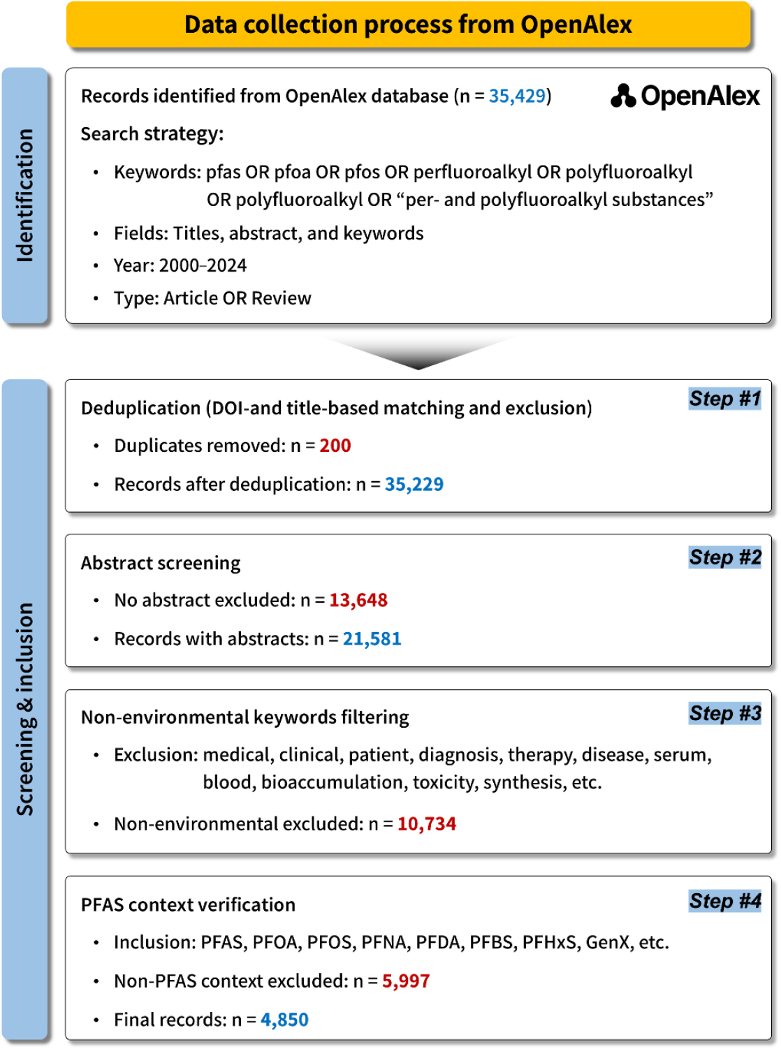
Bibliometric Analysis of PFAS Geological Environment Remediation Research: Temporal changes in Source–Media–Remediation Mechanism Linkage Structure
PFAS 지질환경 정화 연구의 계량서지학적 분석: 오염원–매체–정화기작 연계 구조의 시대별 변화
-
Taeyong Kim, Junyong Heo, Hyerim Lee, Linn Kim, Chiheon Lee, Sanhwi Kim, Taeseop Kim, Minjune Yang
김태용, 허준용, 이혜림, 김 린, 이치헌, 김산휘, 김태섭, 양민준
-
Bibliometric Analysis of PFAS Geological Environment Remediation Research: Temporal changes in Source–Media–Remediation Mechanism Linkage Structure
-
Special Articles
-
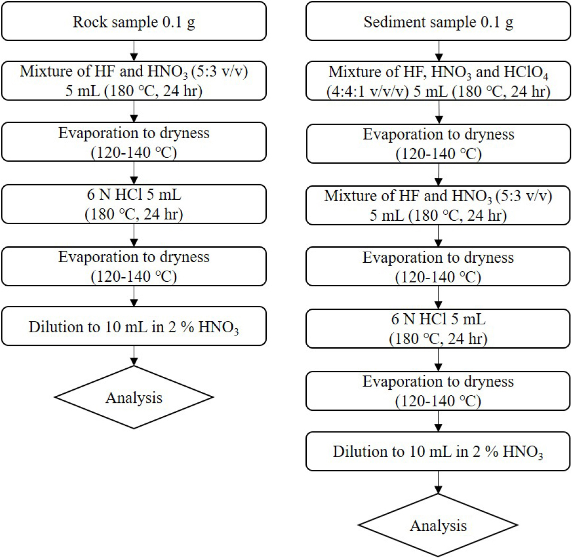
Ensuring Accuracy and Precision in Geochemical Analysis Using Certified and Standard Reference Materials
인증 및 표준 참고물질을 활용한 지구화학 분석의 정확도 및 정밀도 검증
-
Yesun Lee, Insu Kim, Minjune Yang, Jong-Sik Ryu
이예선, 김인수, 양민준, 류종식
-
Ensuring Accuracy and Precision in Geochemical Analysis Using Certified and Standard Reference Materials
-
Research Article
-
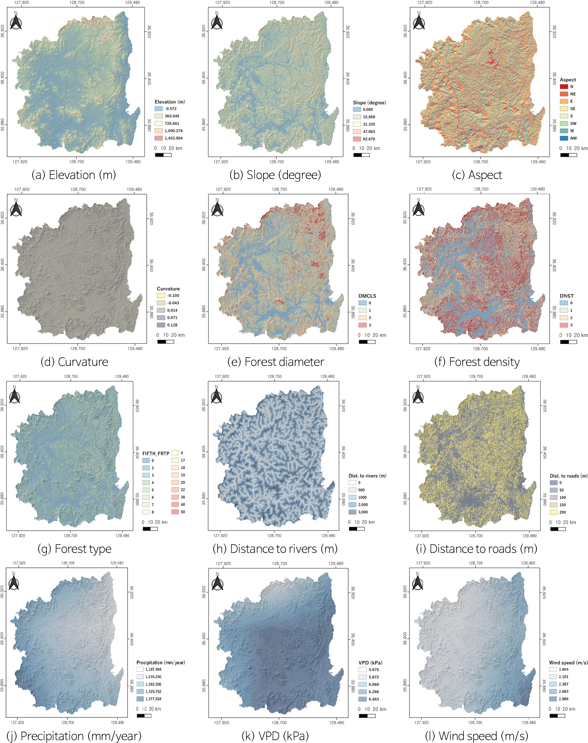
Wildfire Susceptibility Assessment Using AutoML and Geo-Similarity Sampling
AutoML 및 Geo-Similarity 샘플링을 활용한 산불 취약성 평가
-
Kounghoon Nam, Youngkyu Lee, Sungsu Lee, Gyo-Cheol Jeong, Jongtae Kim
남경훈, 이영규, 이승수, 정교철, 김종태
-
Wildfire Susceptibility Assessment Using AutoML and Geo-Similarity Sampling
-
Research Article
-
Evaluation of Three-Dimensional Slope Stability Under Varying Pore Pressure Ratios Using Scoops3D
Scoops3D를 활용한 간극수압비 변화에 따른 3차원 사면 안정성 평가
-
Kounghoon Nam, Youngkyu Lee, Sungsu Lee, Gyo-Cheol Jeong, Jongtae Kim
남경훈, 이영규, 이승수, 정교철, 김종태
-
Evaluation of Three-Dimensional Slope Stability Under Varying Pore Pressure Ratios Using Scoops3D
-
Research Article
-
On Possibility of Deep Learning-Based Earth Dam Safety Monitoring Using Passive Seismic Method
심층학습 기반 수동 탄성파 탐사 이용 사력댐 안정성 감시 가능성
-
Seonghyung Jang, Donghoon Lee, Yunseok Choi, Yonghwan Joo, Keun-Soo Lee
장성형, 이동훈, 최윤석, 주용환, 이근수
-
On Possibility of Deep Learning-Based Earth Dam Safety Monitoring Using Passive Seismic Method
-
Research Article
-
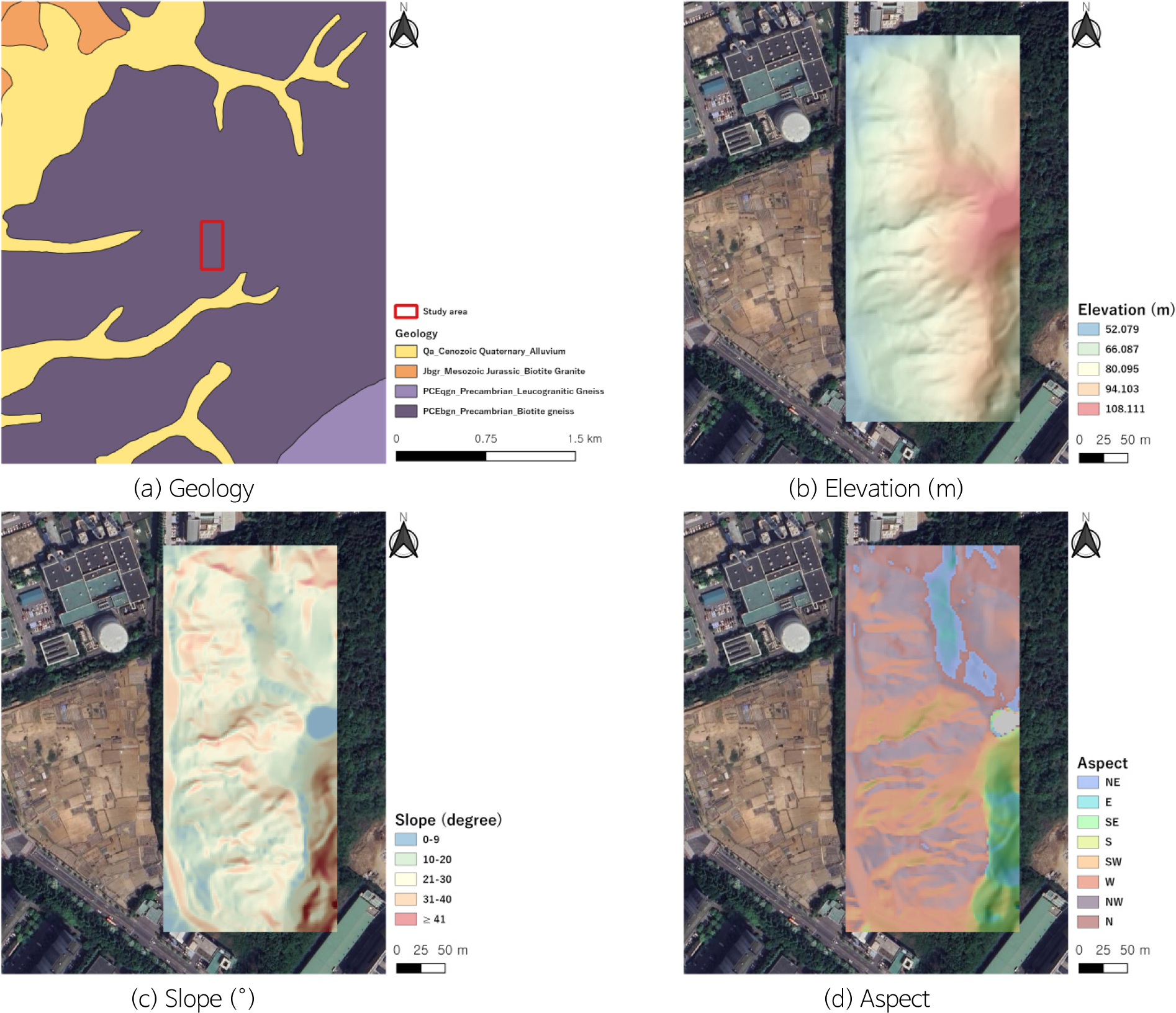
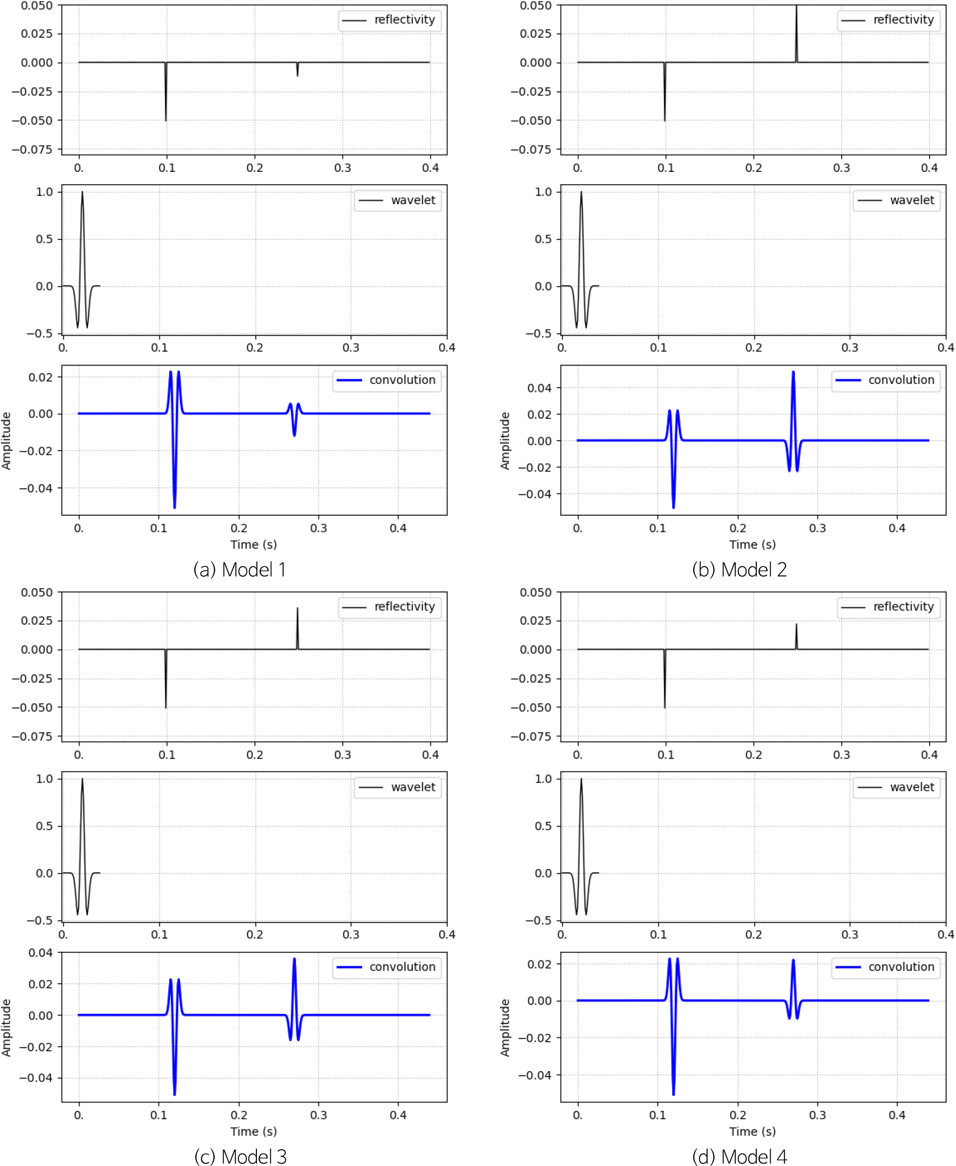
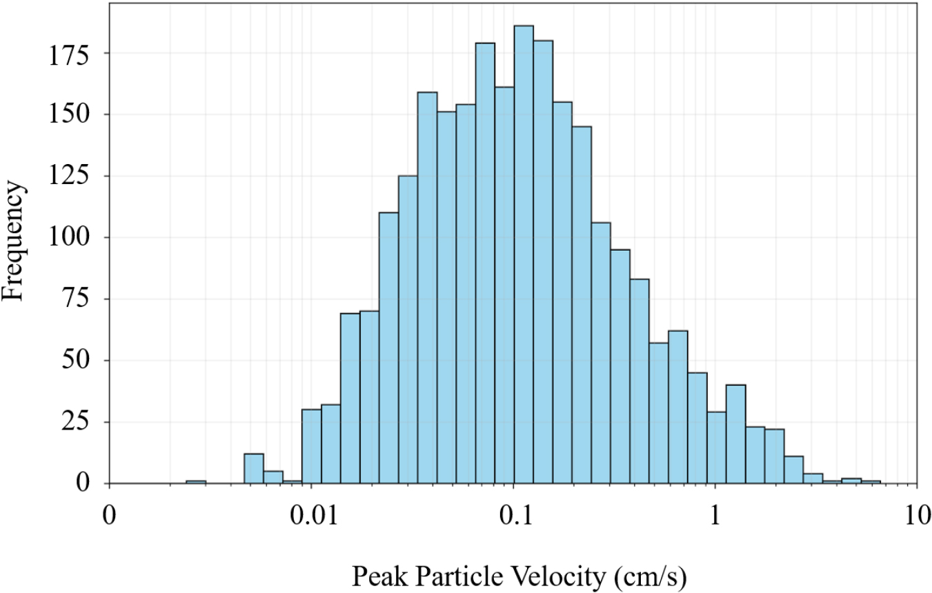
Development of Empirical Blast Vibration Prediction Equations Considering Rock Type Characteristics
암종별 특성을 고려한 발파 진동 예측을 위한 경험적 진동추정식 개발
-
Yo-Hyun Choi, Seung-Hyun Kim, Woo-Seok Kim, Byung-Suk Park, Sung-Pil Hwang, Min-Koan Kim, Sang-Yun Lee, Yong-Hoon Woo, Min-Seong Kim
최요현, 김승현, 김우석, 박병석, 황성필, 김민관, 이상연, 우용훈, 김민성
-
Development of Empirical Blast Vibration Prediction Equations Considering Rock Type Characteristics
-
Research Article
-
Research Article
-
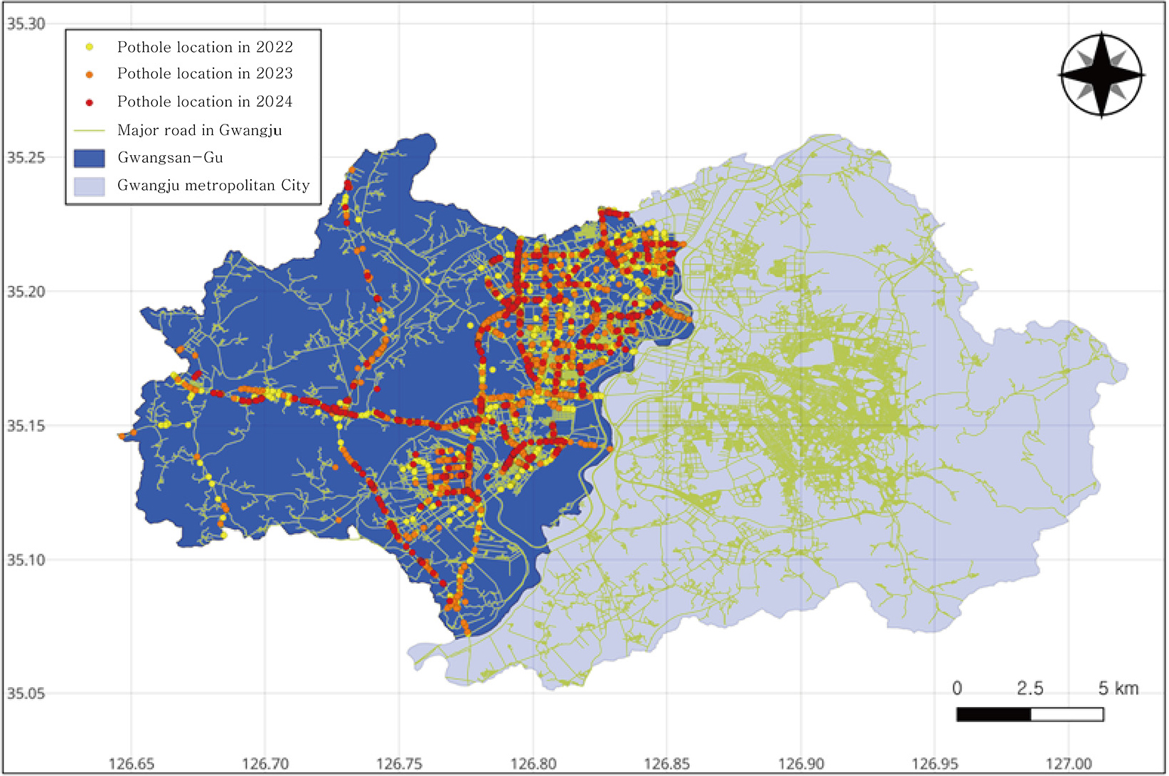
Proposing an Object Recognition Model for Analyzing Traffic Characteristics in Urban Pothole-Prone Areas
도심지 포트홀 발생 구간의 교통 특성 분석을 위한 객체 인식 모델 제안
-
Jeongdu Noh, Seokjin Oh, Hyeok Seo
노정두, 오석진, 서 혁
-
Proposing an Object Recognition Model for Analyzing Traffic Characteristics in Urban Pothole-Prone Areas
-
Research Article
-
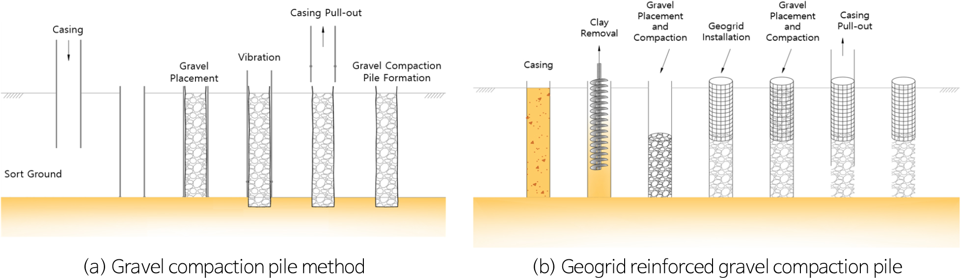
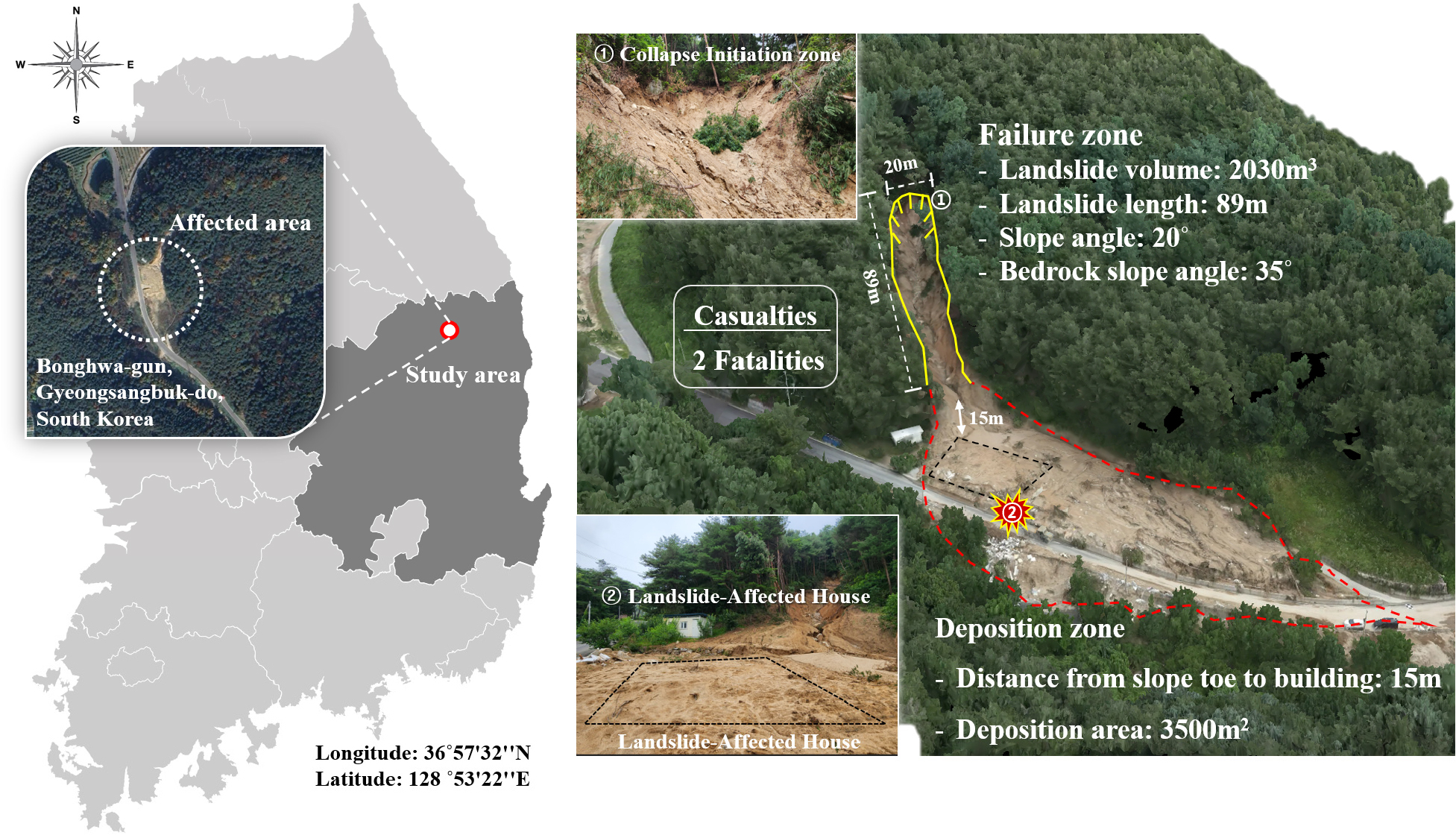
Experimental Study on the Structural Vulnerability Evaluation of Masonry House under Debris Impact and Proposed Reinforcement Condition
실증실험 기반 토사재해에 따른 조적조 주택의 구조적 취약성 평가 및 보강 설계조건 제안
-
HyoSung Song, SeungJae Lee, JaeJung Kim, Dugkeun Park, YoungHak Lee
송효성, 이승재, 김재정, 박덕근, 이영학
-
Experimental Study on the Structural Vulnerability Evaluation of Masonry House under Debris Impact and Proposed Reinforcement Condition
-
Research Article
-
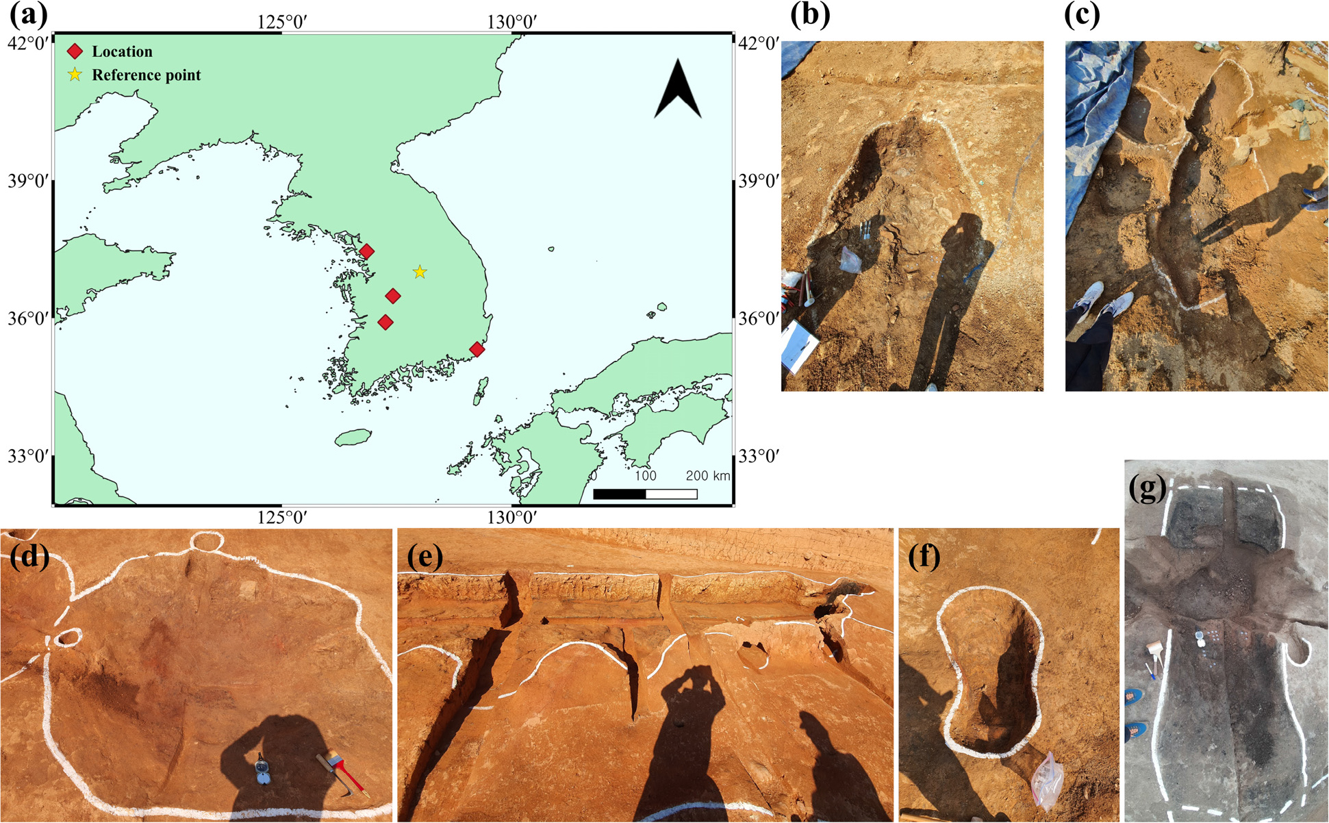
A Comparative Study of Archaeomagnetic Dating Results on the Korean Peninsula Based on Paleosecular Variation Models
영년변화 모델에 따른 한반도 고고지자기 연대측정 결과의 비교 연구
-
Jong Kyu Park, Yong-Hee Park
박종규, 박용희
-
A Comparative Study of Archaeomagnetic Dating Results on the Korean Peninsula Based on Paleosecular Variation Models
-
Technical Note
-
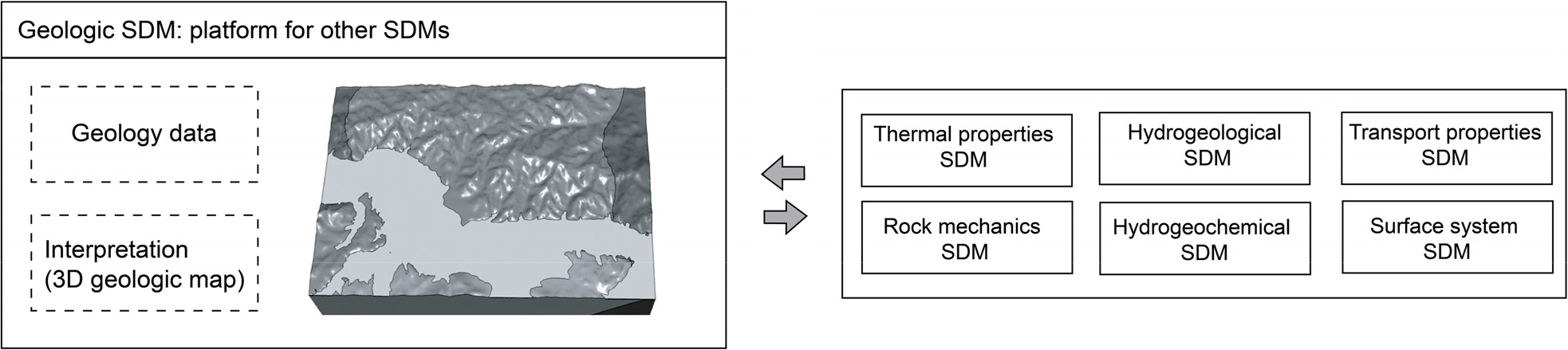
Three-Dimensional Geologic Modeling of a Deep Geologic Repository for High-Level Nuclear Waste: A Point-Cloud Approach Using Surface Geology Data
사용후핵연료 심층처분을 위한 결정질암 부지 3차원 기반모델 구축: 지표 지질자료와 포인트 클라우드를 활용한 접근법
-
Seon-Kyoung Kim, Minae Guk, Siyoung Choi, Jung-Hoon Park
김선경, 국민애, 최시영, 박정훈
-
Three-Dimensional Geologic Modeling of a Deep Geologic Repository for High-Level Nuclear Waste: A Point-Cloud Approach Using Surface Geology Data
-
Technical Note
-
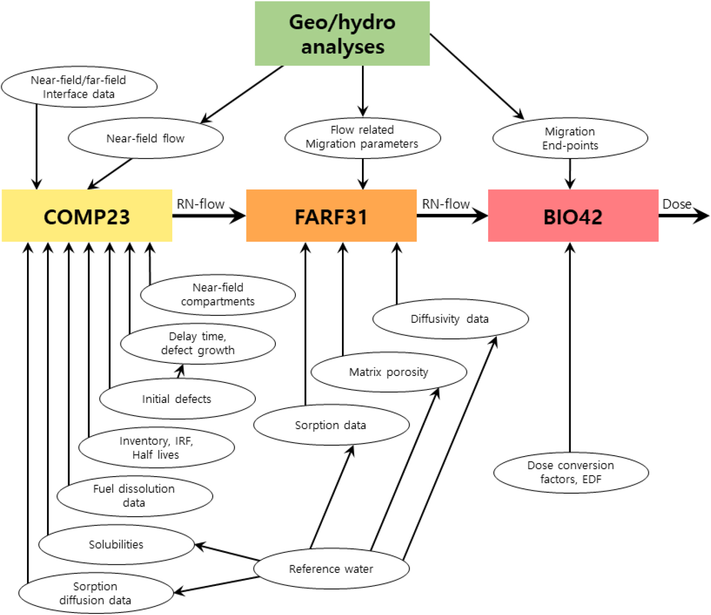
A Review on Requirements and Preferences of Rock of a Deep Geological Repository for High-Level Radioactive Waste in Sweden
스웨덴의 고준위방사성폐기물 심층처분시설 암석 요건 및 선호 사항 고찰
-
Jeong-Hwan Lee, Mi-Jin Kwon, Hyemin Han
이정환, 권미진, 한혜민
-
A Review on Requirements and Preferences of Rock of a Deep Geological Repository for High-Level Radioactive Waste in Sweden

Journal Informaiton
 The Journal of Engineering Geology
The Journal of Engineering Geology


대한지질공학회
Room 4311, Daejeon Universtiy, 62 Daehak-ro, Dong-gu, Daejeon 34520, Korea
Tel: +82-42-280-2737 / Fax: +82-42-280-4575 / E-mail: parkyc@kangwon.ac.kr Copyright© Korean Society of Engineering Geology. Powered by APUB
Tel: +82-42-280-2737 / Fax: +82-42-280-4575 / E-mail: parkyc@kangwon.ac.kr Copyright© Korean Society of Engineering Geology. Powered by APUB