
-
Research Article
-
Correlation Analysis between LFWD and PLT Based on Soil Conditions and a Review of Existing Empirical Formulas
지반조건에 따른 소형충격재하시험과 평판재하시험의 상관관계 분석 및 기존 제안식 고찰
-
Chun Mok Park, Yoon Hwa Jin
박춘목, 진윤화
- The plate loading test (PLT) is primarily utilized as a compaction evaluation method. While highly reliable, it is time-consuming and costly. To …
다짐도 판정기법으로는 평판재하시험을 주로 이용한다. 신뢰도가 높은 시험이지만 많은 시간과 비용이 소모되는 단점이 있다. 따라서, 국토교통부에서는 이러한 문제점을 개선하기 위해 소형충격재하시험을 통한 …
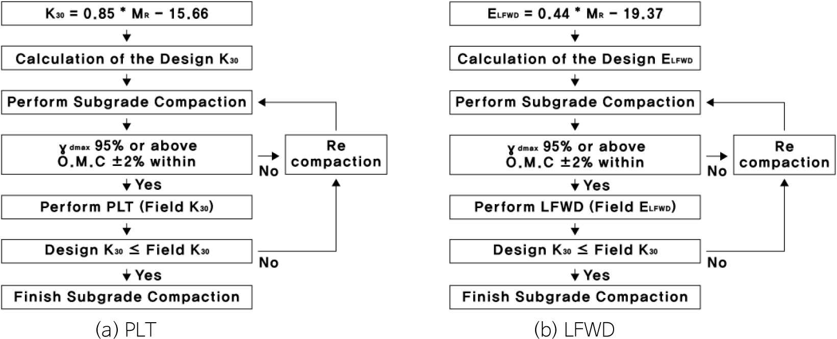
- The plate loading test (PLT) is primarily utilized as a compaction evaluation method. While highly reliable, it is time-consuming and costly. To address these drawbacks, the Ministry of Land, Infrastructure and Transport proposed an alternative method utilizing the light falling weight deflectometer (LFWD). However, practical applications of the LFWD for compaction evaluation remain virtually non-existent to date. This is largely because most existing empirical formulas correlating the PLT and LFWD uniformly established relationships without reflecting specific soil conditions. Therefore this study conducted field tests by categorizing soil conditions into aggregate and soil. The correlations for each condition were established, and an evaluation of existing empirical formulas was performed. The findings revealed that while the correlation for soil was similar to existing formulas, the correlation for aggregate was completely unrelated. Accordingly, this study proposes new correlations tailored to these specific soil conditions. Ultimately, to enhance field applicability, it is imperative to accumulate extensive test data under diverse conditions to establish highly reliable correlations.
- COLLAPSE
다짐도 판정기법으로는 평판재하시험을 주로 이용한다. 신뢰도가 높은 시험이지만 많은 시간과 비용이 소모되는 단점이 있다. 따라서, 국토교통부에서는 이러한 문제점을 개선하기 위해 소형충격재하시험을 통한 다짐도 판정 기법을 제안하였다. 그러나, 현재까지 소형충격재하시험을 통한 다짐도 판정 사례는 전무한 실정이다. 이는 평판재하시험과 소형충격재하시험 간의 상관관계에 대한 기존 제안식이 대부분 지반조건에 따른 시험결과를 반영하지 않고, 일괄적으로 상관관계를 규명하였기 때문이다. 따라서 본 연구에서는 골재와 토사로 지반조건을 구분하여 시험을 수행하였다. 그리고 각 시험에 따른 상관관계를 규명하고, 기존 제안식에 대한 고찰을 수행하였다. 토사에 대한 상관관계는 기존 제안식과 유사하지만 골재에 대한 상관관계는 매우 낮은 것으로 나타났다. 이에 따라 새로운 상관관계를 규명하며, 현장 적용성 향상을 위해 다양한 조건에서 많은 시험 데이터를 축적하여 신뢰도 높은 상관관계 규명이 필요한 것으로 나타났다.
-
Correlation Analysis between LFWD and PLT Based on Soil Conditions and a Review of Existing Empirical Formulas
-
Research Article
-
Engineering Performance and Correlation Analysis of Racetrack Sand as a Function of Fineness Modulus
경주로 모래의 조립률에 따른 공학적 성능 특성 및 상관관계 분석
-
Hwijong Oh, Doogyeong Kim, Hyeok Seo
오휘종, 김두경, 서혁
- Racetrack surface sand must simultaneously satisfy requirements for drainage performance and shear strength. The objective of this study is to investigate the …
경주로 표층 모래는 원활한 경기 운영을 위해 배수 성능과 전단강도를 동시에 만족해야 하며, 주요 품질 지표인 조립률과 공학적 성능 간의 정량적 상관관계를 …
- Racetrack surface sand must simultaneously satisfy requirements for drainage performance and shear strength. The objective of this study is to investigate the quantitative correlation between the fineness modulus (FM)—a key quality control index—and the engineering performance of the sand. To this end, laboratory tests including particle size distribution, constant head permeability, and direct shear tests were performed on original samples (new and 1-year-used racetrack sands, as well as commercial coarse, medium, and fine sands) and silica-mixed samples, followed by regression analysis. The analysis indicated a positive trend between FM and the coefficient of permeability (original samples: R2 = 0.493, silica-mixed samples: R2 = 0.456). Conversely, the correlation between FM and cohesion was low (original samples: R2 = 0.224, silica-mixed samples: R2 = 0.087). The correlation with the internal friction angle was relatively high only in the original sand groups (original samples: R2 = 0.611, silica-mixed samples: R2 = 0.250), suggesting that FM may be more closely related to drainage performance than to shear characteristics, although the explanatory power is limited.
- COLLAPSE
경주로 표층 모래는 원활한 경기 운영을 위해 배수 성능과 전단강도를 동시에 만족해야 하며, 주요 품질 지표인 조립률과 공학적 성능 간의 정량적 상관관계를 규명하는 것이 본 연구의 목적이다. 이를 위해 기존 경주로 모래인 새모래(new sand, NS)와 1년 사용된 모래(aged sand, AS), 시중 모래인 왕사(coarse sand, CS), 중사(medium sand, MS), 세사(fine sand, FS), 그리고 혼합 재료인 규사3호(silica sand, SS-3)를 대상으로 입도분포, 정수위 투수, 직접전단 시험을 수행하고 회귀분석을 진행하였다. 분석 결과, 조립률과 투수계수간에는 증가 경향(기존시료: R2 = 0.493, 혼합시료: R2 = 0.456)이 확인되었다. 반면 점착력과의 상관성(기존시료: R2 = 0.224, 혼합시료: R2 = 0.087)은 낮았고, 내부마찰각과의 상관성(기존시료: R2 = 0.611, 혼합시료: R2 = 0.250)은 기존시료에서만 비교적 높은 상관성을 보여, 조립률이 전단특성보다는 배수 성능과 더 관련 있음이 확인되었으나, 그 설명력은 제한적인 수준으로 판단된다. 또한 단가(원/m3)를 포함한 성능-비용 분석을 수행한 결과, FS-SS-3 혼합을 통해 목표 조립률을 조정함으로써 기준 투수계수를 만족하면서도 경제성을 확보할 수 있는 구간이 존재함을 확인하였다. 이는 조립률이 경주로 모래의 배수 성능을 관리하기 위한 보조적 관리 지표로 활용될 수 있으며, 혼합 설계를 통해 성능과 경제성을 동시에 고려한 합리적인 재료 선정이 가능함을 제시한다.
-
Engineering Performance and Correlation Analysis of Racetrack Sand as a Function of Fineness Modulus
-
Research Article
-
Analysis of Research Trends in Landslide Studies through Co-Occurrence Word Analysis
동시출현단어 분석을 통한 산사태 연구 동향
-
Eunseok Jeong, Subin Kim, Jaehyeon Park
정은석, 김수빈, 박재현
- In recent years, the frequency and magnitude of landslide disasters have increased due to the rise in extreme rainfall associated with climate …
기후변화로 인한 극한 호우 증가로 산사태로 인한 산지재해의 발생 빈도와 규모가 증가하고 있다. 이에 따라 산사태 연구의 체계적인 동향 파악의 필요성이 커지고 …
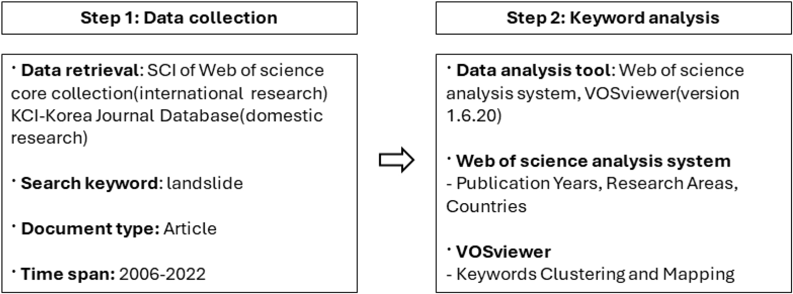
- In recent years, the frequency and magnitude of landslide disasters have increased due to the rise in extreme rainfall associated with climate change. Consequently, there is a growing need for a systematic understanding of research trends in landslide studies. This study aimed to identify trends in international and domestic landslide research by analyzing research papers published between 2006 and 2022 using co-occurrence word analysis. The results show that international landslide research has steadily increased in volume since 2006, whereas domestic research has shown a declining trend since 2016. In terms of research output by country, South Korea ranked 15th among 166 countries in terms of number of studies published. The co-occurrence word analysis revealed that international research papers can be categorized into four research areas with strong interconnections among them. In contrast, domestic research papers were classified into three research areas with relatively weak interconnections. These findings suggest that future landslide research in Korea should strengthen interdisciplinary collaboration across various research fields and focus on landslide prediction and prevention in response to ongoing climate change.
- COLLAPSE
기후변화로 인한 극한 호우 증가로 산사태로 인한 산지재해의 발생 빈도와 규모가 증가하고 있다. 이에 따라 산사태 연구의 체계적인 동향 파악의 필요성이 커지고 있다. 이 연구는 2006년부터 2022년까지 발표된 국제 및 국내 산사태 관련 연구논문을 수집하고 동시출현단어 분석을 통해 산사태 연구동향을 파악하고자 수행하였다. 분석 결과 국제 산사태 연구는 지속적으로 증가하는 추세를 보인 반면 국내 연구는 2016년 이후 감소하는 경향을 나타냈다. 국가별 연구동향에서는 대한민국이 166개국 중 상위 15위 수준으로 나타났다. 동시출현단어 분석 결과 국제 연구논문은 4개의 연구영역으로 구분되었으며, 연구영역 간 상호연관성이 확인되었다. 반면 국내 연구논문은 3개의 연구영역으로 구분되었으나 연구영역 간 연계성이 상대적으로 낮은 것으로 나타났다. 이러한 결과는 향후 국내 산사태 연구에서 다양한 연구분야 간의 상호연계를 강화하고 기후변화에 대응한 산사태 예측 및 예방 연구의 확대가 필요함을 시사한다.
-
Analysis of Research Trends in Landslide Studies through Co-Occurrence Word Analysis
-
Research Article
-
Comparative Trend Analysis of Deep Disposal Research by SKB and POSIVA Using LDA Topic Modeling
LDA 주제 모델링을 활용한 SKB와 POSIVA의 심층 처분 연구 동향 비교 분석
-
Minhwan Choi, Byung-Gon Chae, Junghae Choi
최민환, 채병곤, 최정해
- This study quantitatively analyzes the long-term research and development (R&D) trends of two leading companies in deep geological disposal, Sweden’s SKB and …
본 연구는 심층 처분 분야 선도국인 스웨덴 SKB와 핀란드 POSIVA의 장기 연구개발(R&D) 경향을 정량적으로 비교·분석하기 위해, 잠재 디리클레 할당(latent Dirichlet allocation, LDA) …
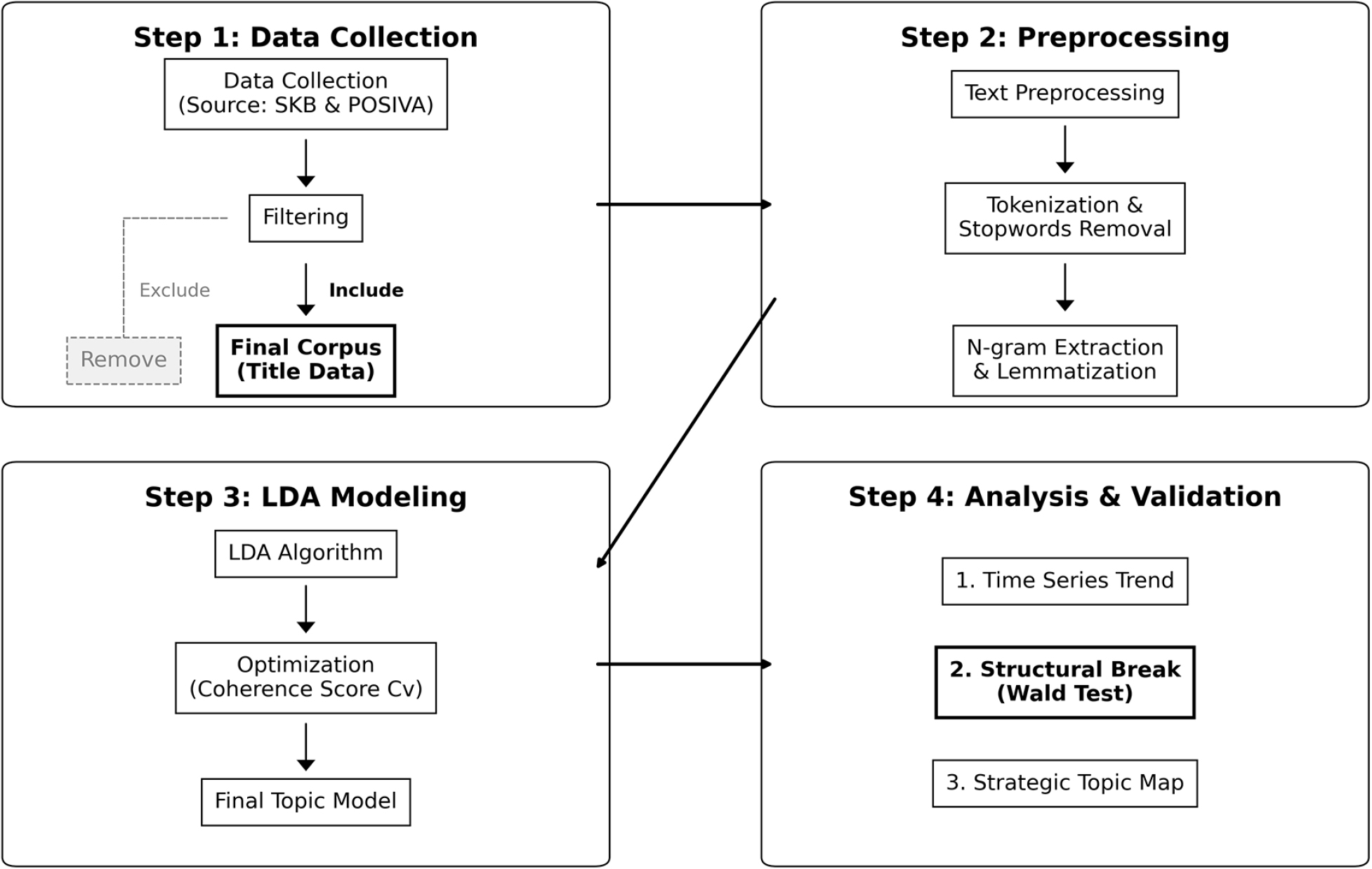
- This study quantitatively analyzes the long-term research and development (R&D) trends of two leading companies in deep geological disposal, Sweden’s SKB and Finland’s POSIVA, using latent Dirichlet allocation (LDA) topic modeling combined with structural break analysis. The dataset consists of 2,520 technical report titles from SKB and 1,014 from POSIVA. The LDA results identify nine major R&D topics for SKB and six for POSIVA. This indicates a relatively diversified research portfolio at SKB (top three topics: 49.6% of the total publications) and a more concentrated portfolio at POSIVA (top three topics: 72.2%). Regression analysis of annual topic proportions (i.e., proportion of the total publications) and Wald tests reveal statistically significant (p < 0.05) structural breaks around the years when the firms applied for a construction license (2011 for SKB and 2012 for POSIVA) in five of nine topics for SKB and three of six topics for POSIVA. In particular, hydrogeological modeling R&D undertaken by SKB shows accelerated growth after the license application, whereas underground site characterization R&D undertaken by POSIVA shows a declining trend, indicating contrasting transitions in research focus. In addition, the average inter-topic similarity is lower for SKB (0.12) than for POSIVA (0.34), reflecting differences in the degree of thematic integration associated with multi-site and single-site strategies, respectively. By applying text mining techniques to the field of deep geological disposal, this study visualizes the evolution of research activities undertaken by leading companies in a data-driven manner. The results are expected to provide useful insights for latecomer countries, including the Republic of Korea, in formulating efficient R&D strategies.
- COLLAPSE
본 연구는 심층 처분 분야 선도국인 스웨덴 SKB와 핀란드 POSIVA의 장기 연구개발(R&D) 경향을 정량적으로 비교·분석하기 위해, 잠재 디리클레 할당(latent Dirichlet allocation, LDA) 주제 모델링과 구조적 단절 분석을 적용하였다. 분석 대상은 SKB의 기술보고서 제목 2,520건과 POSIVA의 기술보고서 제목 1,014건이다. LDA 분석 결과, SKB는 9개, POSIVA는 6개의 주요 연구 주제가 도출되었으며, SKB는 상대적으로 분산된 연구 포트폴리오(상위 3개 주제 비중 49.6%)를, POSIVA는 보다 집중된 포트폴리오(상위 3개 주제 비중 72.2%)를 보였다. 연도별 주제 비중에 대한 회귀 분석과 Wald 검정 결과, 건설 허가 신청(SKB: 2011년, POSIVA: 2012년)을 기점으로 SKB는 9개 중 5개 주제, POSIVA는 6개 중 3개 주제에서 통계적으로 유의한 구조적 변화(p < 0.05)가 관찰되었다. 특히 SKB의 수리지질학 모델링 연구는 허가 신청 이후 증가 속도가 가속화된 반면, POSIVA의 현장 특성화 연구는 감소 추세로 전환되어 두 기관 간 상이한 연구 단계 전환 양상이 확인되었다. 또한 주제 간 평균 유사도는 SKB (0.12)가 POSIVA (0.34)보다 낮아, 복수 부지 평가 전략과 단일 부지 집중 전략에 따른 연구 주제 통합도의 차이를 반영하는 것으로 해석되었다. 본 연구는 심층 처분 분야에 텍스트 마이닝 기법을 적용하여 선도국의 연구 진화 과정을 데이터 기반으로 가시화하였으며, 그 결과는 대한민국을 포함한 후발국의 효율적인 R&D 전략 수립을 위한 참고 자료로 활용될 수 있을 것으로 기대된다.
-
Comparative Trend Analysis of Deep Disposal Research by SKB and POSIVA Using LDA Topic Modeling
-
Research Article
-
Assessment of Landcreep Risk Areas through Logistic Regression Analysis
로지스틱 회귀분석을 통한 땅밀림지 위험 평가
-
Sanghyeon Lee, Seonghun Park, Jaehyeon Park
이상현, 박성훈, 박재현
- This study identified landcreep (i.e., a slow-moving landslide) susceptibility in Gyeongsangnam-do and Gyeongsangbuk-do using logistic regression analysis based on elevation, slope, geology, …
이 연구는 경상남북도에서 발생한 땅밀림지와 비땅밀림지의 대상으로 표고, 경사, 지질, 임상, 지형습윤지수, 사면곡률, 수계와의 거리, 도로와의 거리를 로지스틱 회귀분석을 이용하여 땅밀림 위험지를 …
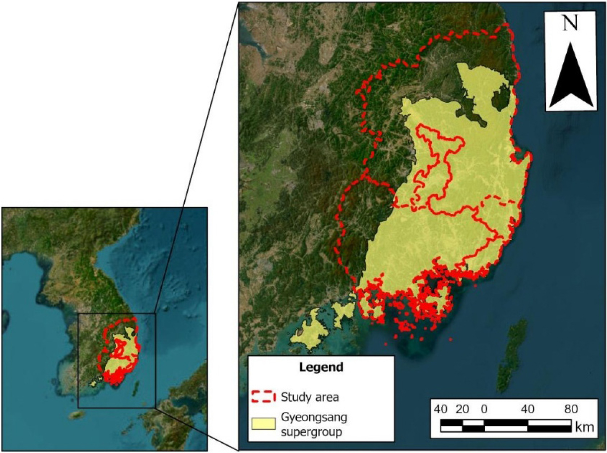
- This study identified landcreep (i.e., a slow-moving landslide) susceptibility in Gyeongsangnam-do and Gyeongsangbuk-do using logistic regression analysis based on elevation, slope, geology, vegetation type, topographic wetness index, slope curvature, distance from waterways, and distance from roads. Spatial analysis was conducted using a 1.5 ha circular buffer for 92 landcreep sites and 92 non-landcreep sites in the study area. The logistic regression analysis revealed that vegetation type, profile curvature, and distance from roads had statistically significant effects on landcreep occurrence. Model validation yielded a Nagelkerke value of 0.375 and a Hosmer–Lemeshow significance probability of 0.545, suggesting that the model outputs are statistically reliable. Landcreep susceptibility was classified using variables that are statistically significant according to the logistic regression analysis. Grades 1 and 2, representing high-risk areas, accounted for 53.3% of the study area, indicating a moderate prediction rate.
- COLLAPSE
이 연구는 경상남북도에서 발생한 땅밀림지와 비땅밀림지의 대상으로 표고, 경사, 지질, 임상, 지형습윤지수, 사면곡률, 수계와의 거리, 도로와의 거리를 로지스틱 회귀분석을 이용하여 땅밀림 위험지를 판별하였다. 경상남북도의 땅밀림지와 비땅밀림지 각각 92개소를 대상으로 1.5 ha 원형버퍼를 구획하여 공간분석을 실시하였다. 로지스틱 회귀분석을 통해 통계적으로 유의한 영향을 미친 요인은 식생, 곡률(profile), 도로와의 거리이었으며, 모델 검증결과 Nagelkerke R2은 0.375, Hosmer & Lemeshow 유의확률은 0.545로 모델이 적합함을 나타냈다. 로지스틱 회귀분석에서 유의성이 있었던 5가지 종속변수를 이용하여 땅밀림 위험지를 판별하였으며, 위험지를 나타내는 1–2등급의 합계는 53.3%의 판별률을 나타냈다. 이 연구를 통해 땅밀림 위험 판별지도를 구축하였다.
-
Assessment of Landcreep Risk Areas through Logistic Regression Analysis
-
Research Article
-
Behavioral Analysis of Retaining Walls in Colluvial and Talus Layers Based on Field Monitoring and Ground Properties
Talus를 포함한 붕적토층에 시공된 절토부옹벽의 지반 특성 및 계측 기반 거동 분석
-
Jaehyu Mun, Hyeok Seo, Daehyeon Kim
문재휴, 서혁, 김대현
- This study was conducted to investigate the causes of displacement in a cut-slope retaining wall constructed on colluvial soil layers containing Talus …
본 연구는 여수 지역의 Talus를 포함한 붕적토층에 시공된 절토부옹벽에서 발생한 변위의 원인을 규명하기 위해 수행되었다. 시공 단계에서 발생한 벽체 변위 메커니즘을 분석하고자 …
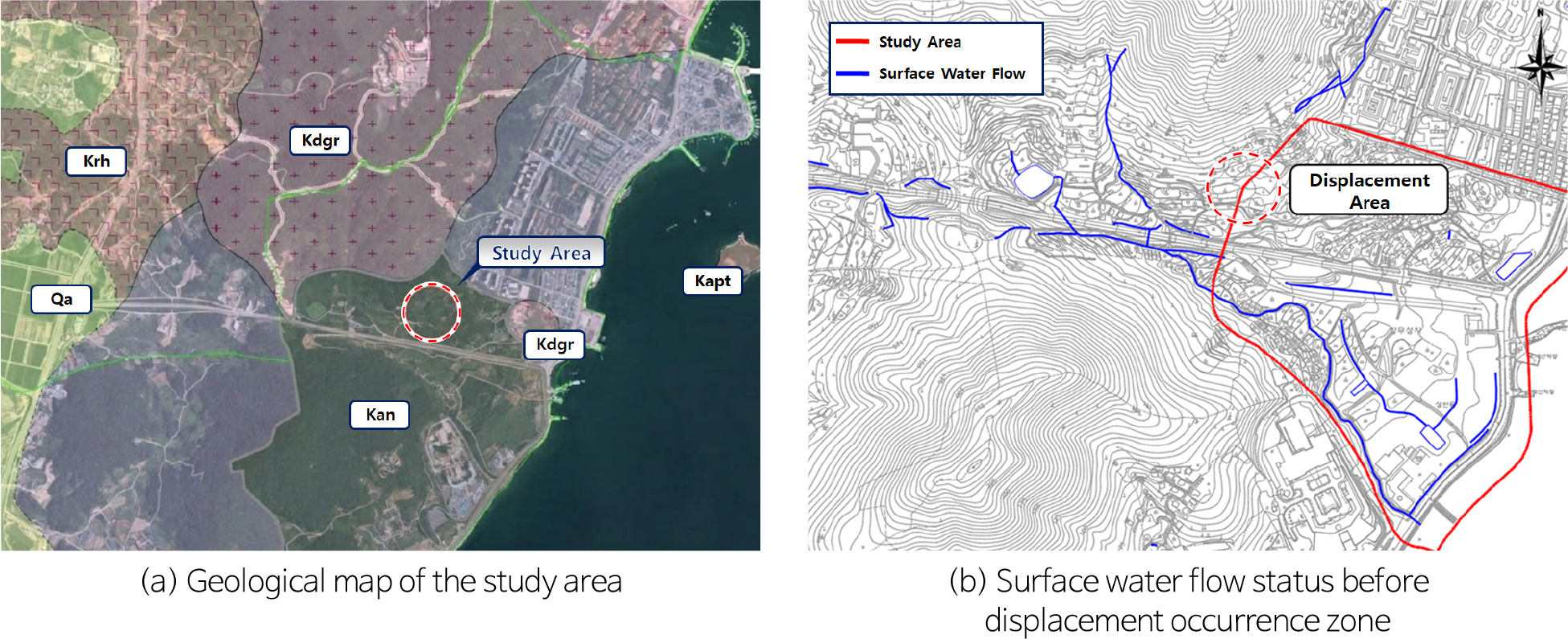
- This study was conducted to investigate the causes of displacement in a cut-slope retaining wall constructed on colluvial soil layers containing Talus in the Yeosu area. To analyze the wall displacement mechanism occurring during the construction phase, a comprehensive geotechnical investigation was performed, including electrical resistivity surveys, groundwater flow direction and velocity tests, and monitoring of inclinometers and groundwater level gauges. The results indicated that groundwater stagnation occurred during rainfall at the interface between the highly permeable colluvial soil and the underlying low-permeability weathered soil. In particular, the rapid rise in groundwater level to the foundation depth (EL. 65–74 m) immediately following heavy rainfall (daily precipitation exceeding 55.3 mm) was analyzed as a major factor inducing displacement by increasing backfill water pressure. Inclinometer analysis revealed a maximum frontal displacement of 18.8 mm in the No.6+0.0 section, showing a close correlation with localized groundwater concentration due to topographical catchment characteristics. These findings suggest that fluctuations in groundwater levels, driven by the hydraulic properties of soil layers in complex grounds such as colluvial soil, can significantly impact structural stability. Therefore, it is essential to establish effective drainage systems, such as horizontal drains, along with stability reviews for each construction stage.
- COLLAPSE
본 연구는 여수 지역의 Talus를 포함한 붕적토층에 시공된 절토부옹벽에서 발생한 변위의 원인을 규명하기 위해 수행되었다. 시공 단계에서 발생한 벽체 변위 메커니즘을 분석하고자 전기비저항 탐사, 유향·유속 시험, 지중경사계 및 지하수위계 계측을 포함한 종합적인 지반조사를 실시하였다. 분석 결과, 투수성이 높은 붕적토층과 하부의 저투수성 풍화토 경계면에서 강우 시 지하수 정체 현상이 발생하는 것으로 나타났다. 특히 일강수량 55.3 mm 이상의 집중호우 직후 지하수위가 옹벽 기초부 심도(EL.65–74 m)까지 급격히 상승하며 배면 수압을 증대시킨 것이 변위 발생을 유도하는 주요 원인으로 분석되었다. 지중경사계 분석 결과 No.6+0.0 구간에서 최대 18.8 mm의 전면 변위가 관측되었으며, 이는 지형적 집수 특성에 따른 국지적 지하수 집중 현상과 밀접한 상관관계를 보였다. 이러한 결과는 붕적토 등 복합 지반 내 옹벽 설계 시 지층의 수리적 특성에 따른 지하수위 변동이 구조물 안정성에 지대한 영향을 미칠 수 있음을 시사하며, 향후 시공 단계별 안정성 검토와 수평배수공 등 효율적인 배수 체계 수립이 필수적임을 보여준다.
-
Behavioral Analysis of Retaining Walls in Colluvial and Talus Layers Based on Field Monitoring and Ground Properties
-
Research Article
-
Characterization of Topsoil Damage by Geological Types and Analysis of On-Site Restoration Efficiency
지질 유형별 표토 훼손 특성 평가 및 현장 복원 효율 분석
-
Jae-Jin Choi, Kyeong-Hun Cha, Gyo-Cheol Jeong, Jong-Tae Kim, Kounghoon Nam, Seong-Cheol Park
최재진, 차경훈, 정교철, 김종태, 남경훈, 박성철
- Topsoil is a critical natural resource that supports key ecosystem services, including carbon cycling, water retention and purification, flood mitigation, and biomass …
표토(topsoil)는 탄소 순환, 수자원 저장 및 정화, 홍수 조절, 생물 생산 등 다양한 생태계 서비스를 제공하는 핵심 자연자원이다. 그러나 표토는 형성에 장기간이 …
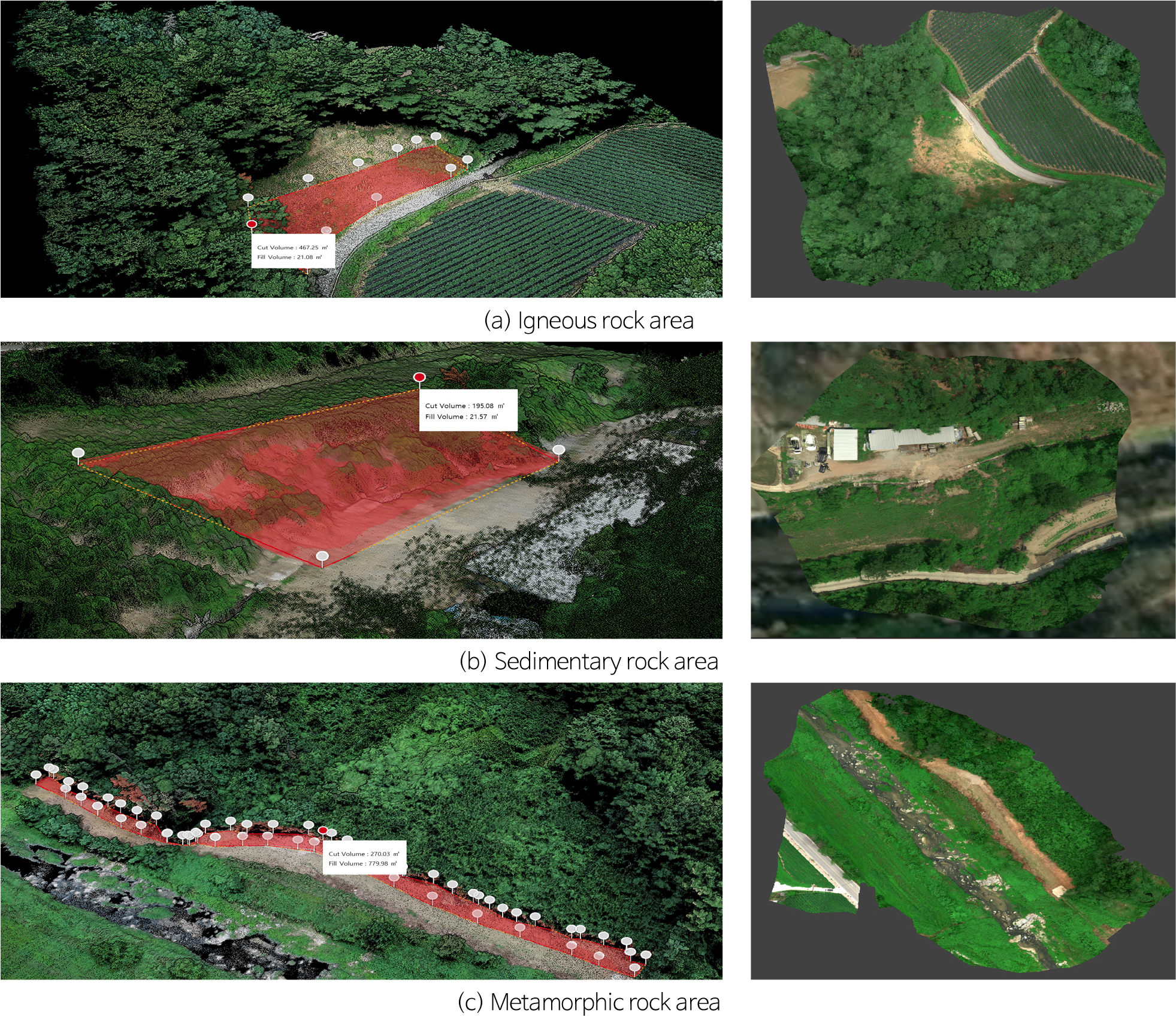
- Topsoil is a critical natural resource that supports key ecosystem services, including carbon cycling, water retention and purification, flood mitigation, and biomass production. However, once degraded, topsoil requires a long period for natural recovery, making active restoration essential. This study evaluated soil properties in degraded topsoil areas by geological type, quantified the extent and volume of degradation using unmanned aerial vehicle (UAV)-based spatial analysis, and assessed the field applicability of geological-type-specific topsoil restoration techniques. Soil physicochemical, biological, and geological properties were analyzed for exposed subsoil and surrounding topsoil in areas of igneous, sedimentary, and metamorphic rock. UAV imagery, orthomosaic, digital surface model (DSM), digital terrain model (DTM), and normalized difference vegetation index (NDVI) analyses were undertaken to estimate the degraded area and volume. Restoration criteria from the geological-type-specific topsoil restoration manual were applied, and restoration was performed by mixing exposed subsoil (70%) with topsoil of the same geological origin (30%). The degraded area was estimated to be 346 m2 in the igneous rock area, 51 m2 in the sedimentary rock area, and 1,351 m2 in the metamorphic rock area, while the degraded volume was estimated to be 488.33, 215.65, and 1,050.01 m3, respectively. Soil analysis showed that exposed subsoil generally had lower chemical fertility and higher bulk density than surrounding topsoil. The restored topsoil in all three geological types satisfied the Grade I criteria of the restoration manual. The results indicate that the use of geological-type-specific restoration criteria and same-origin topsoil mixing is an effective approach for restoring degraded topsoil functions in the field.
- COLLAPSE
표토(topsoil)는 탄소 순환, 수자원 저장 및 정화, 홍수 조절, 생물 생산 등 다양한 생태계 서비스를 제공하는 핵심 자연자원이다. 그러나 표토는 형성에 장기간이 소요되는 반면 훼손될 경우 자연적인 회복이 어렵기 때문에 체계적인 복원 기술의 적용이 필요하다. 본 연구에서는 지질 유형별 표토 훼손 부지를 대상으로 토양 특성을 분석하고, 무인항공기(Unmanned Aerial Vehicle, UAV) 기반 공간정보 분석을 통해 훼손 범위와 훼손량을 산정한 후 지질별 표토 복원 기준을 적용한 현장 복원 및 복원 효율 평가를 수행하였다. 화성암, 퇴적암, 변성암 지역을 대상으로 노출 심토와 주변 표토의 물리·화학·생물학적 및 지질학적 특성을 비교 분석하였다. 또한 UAV 영상, 정사영상 제작, 디지털 표면 모델(Digital Surface Model, DSM), 디지털 지형 모델(Digital Terrain Model, DTM) 및 정규식생지수(Normalized Difference Vegetation Index, NDVI) 분석을 활용하여 표토 훼손 면적과 체적을 산정하였다. 분석 결과, 표토 훼손 면적은 화성암 지역 346 m2, 퇴적암 지역 51 m2, 변성암 지역 1,351 m2로 나타났으며, 훼손 체적은 각각 488.33 m3, 215.65 m3, 1,050.01 m3로 산정되었다. 토양 분석 결과 노출 심토는 주변 표토에 비해 화학적 비옥도와 생물학적 활성이 낮고 단위중량은 높은 경향을 나타내었다. 표토 복원은 노출 심토 70%와 동일 지질 기원의 표토 30%를 혼합하는 방식으로 수행하였다. 복원 후 토양 특성 분석 결과 화성암, 퇴적암 및 변성암 지역 모두에서 복원된 토양이 지질별 표토 Ⅰ등급 기준을 만족하는 것으로 확인되었다. 이러한 결과는 지질 유형별 복원 기준을 적용하고 동일 지질 기원의 표토를 혼합하는 방식이 훼손된 표토의 기능을 효과적으로 회복시키는 방법임을 보여준다.
-
Characterization of Topsoil Damage by Geological Types and Analysis of On-Site Restoration Efficiency
-
Research Article
-
Removing the Groundwater Level Effect from Borehole Strainmeter Data
시추공 변형률계 자료에서 지하수위 유발 효과 제거 방법
-
Minjoo Yeo, Jinseong Moon, Chandong Chang, Hansol Kim
여민주, 문진성, 장찬동, 김한솔
- Borehole strainmeters are useful for monitoring long-term crustal deformation because they continuously record small subsurface deformation at high resolution. However, strainmeter records …
시추공 변형률계는 지각 내 미세 변형을 고해상도로 연속 관측할 수 있어 장기 지각 변형 해석에 유용하다. 그러나 실제 관측 자료에는 지구조적 변형 …
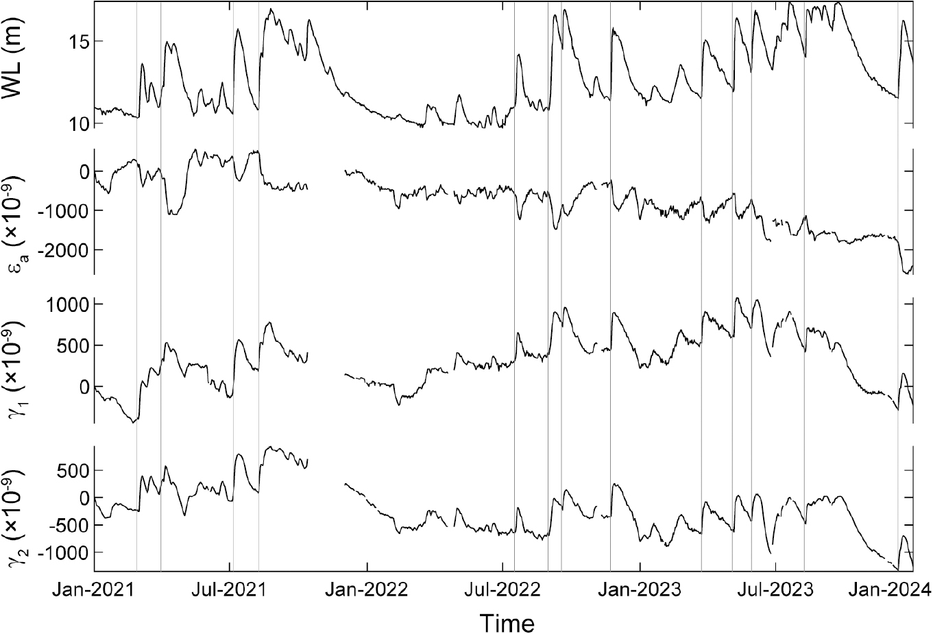
- Borehole strainmeters are useful for monitoring long-term crustal deformation because they continuously record small subsurface deformation at high resolution. However, strainmeter records may contain non-tectonic components caused by environmental factors, increasing uncertainty in their interpretation. In this study, we investigate the effects of groundwater-level changes on borehole strainmeter data from a site in southeastern Korea and propose an empirical correction to remove groundwater-induced strain components. Analysis of rainfall, groundwater level, areal strain, and two shear-strain components from 2021 to 2023 shows that groundwater levels generally increased following rainfall. The daily change in groundwater level exhibits the strongest response within ~1 day after rainfall, indicating that the major short-term fluctuations in groundwater level during the study period were primarily associated with rainfall recharge. For 14 events characterized by rapid groundwater-level rises, changes in the areal and shear strains show approximately linear relationships with groundwater-level change. These relationships are used to derive empirical correction coefficients for groundwater-induced strain. Applying the correction substantially reduces repetitive short-term strain variations associated with groundwater-level fluctuations and makes long-term trends in the strain records clearer to identify. The results demonstrate that a site-specific groundwater-level correction can improve the interpretability of borehole strainmeter records. However, the tectonic significance of the residual long-period variations requires further evaluation using independent observations.
- COLLAPSE
시추공 변형률계는 지각 내 미세 변형을 고해상도로 연속 관측할 수 있어 장기 지각 변형 해석에 유용하다. 그러나 실제 관측 자료에는 지구조적 변형 신호 외에도 다양한 환경 요인에 의한 비지구조적 성분이 포함될 수 있어 자료 해석의 불확실성을 증가시킨다. 본 연구에서는 지하수위 변화가 시추공 변형률계 자료에 미치는 영향을 분석하고, 지하수위 유발 성분을 제거하기 위한 경험적 보정 방법을 제시하였다. 2021년부터 2023년까지의 강수량, 지하수위, 면적변형률 및 전단변형률 자료를 분석한 결과, 연구 지역의 지하수위는 강수 이후 뚜렷하게 상승하며, 특히 일별 지하수위 변화량은 강수 발생 후 약 1일 이내에 가장 큰 반응을 보였다. 이는 지하수위 변동의 주요 원인이 강수의 지하 침투와 이에 따른 공극압 증가임을 지시한다. 지하수위가 급격히 상승하는 구간을 대상으로 수위 변화량과 변형률 변화량 사이의 관계를 분석한 결과, 면적변형률과 두 전단변형률 모두 지하수위 변화와 선형적인 상관성을 보였으며, 이를 바탕으로 지하수위 유발 변형률 보정식을 도출하였다. 보정 후 자료에서는 지하수위 변동에 따른 반복적인 단기 변형 성분이 크게 감소하였고, 전처리 자료에서 불명확했던 장기 변형 추세가 뚜렷하게 나타났다. 보정 결과는 지하수위 보정이 시추공 변형률계 자료의 신호 대 잡음비를 향상시키고, 장기 지각 변형 해석의 신뢰도를 높이는 데 효과적임을 보여준다.
-
Removing the Groundwater Level Effect from Borehole Strainmeter Data
-
Research Article
-
An Integrated Model for Forensic Accident Investigation Based on Geotechnical Engineering
지반공학적 기반의 포렌식 사고조사 통합 모델에 관한 연구
-
Bon-Min Gu, Yong Back, Byong-Kuk Kim
구본민, 백용, 김병국
- In recent years, ground subsidence, excavation collapse, earth retaining wall failure, and slope slip have occurred at construction sites as symptoms of …
최근 건설현장의 지반침하와 굴착 붕괴 및 흙막이 파괴 그리고 사면활동 등은 지반 조건의 불확실성과 설계 가정의 단순화 및 시공 중 응력 재분포, …
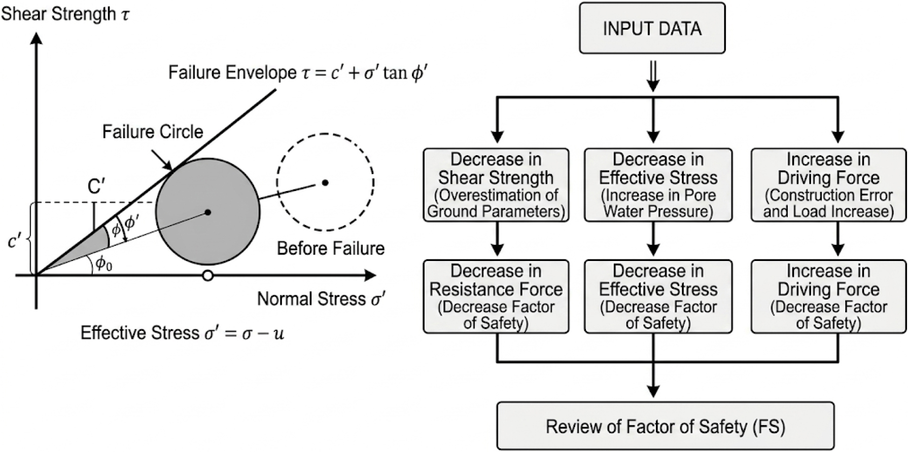
- In recent years, ground subsidence, excavation collapse, earth retaining wall failure, and slope slip have occurred at construction sites as symptoms of the failures of multifactorial systems resulting from a complex interplay of factors, including uncertainty in the ground conditions, simplification of design assumptions, stress redistribution during construction, and inadequate measurement and management systems. However, domestic accident investigation systems currently focus on identifying administrative liability, leading to a lack of quantitative verification and standardized construction forensic systems. In this context, the present study proposes a standard forensic investigation model based on geology and geotechnical engineering that integrates quantitative stability assessment, measurement-based back-analysis, and a hierarchical analysis of root causes. The aim is to transition to a scientific and engineering analysis system that includes reproducibility and verification procedures compliant with international quality standards for the recalculation of safety factors and sensitivity analysis between parameters, considering the ground characteristics.
- COLLAPSE
최근 건설현장의 지반침하와 굴착 붕괴 및 흙막이 파괴 그리고 사면활동 등은 지반 조건의 불확실성과 설계 가정의 단순화 및 시공 중 응력 재분포, 계측·관리체계 미흡 등과 같이 복합적으로 작용하는 다요인적 시스템의 실패 형태로 나타난다. 그러나 국내 사고조사체계는 행정적 책임 규명 중심으로 운영되어 정량적 검증과 표준화된 건설 포렌식 체계가 부족한 실정이다. 이에 본 연구는 정량적 안정성 평가와 계측 기반의 역해석 및 근본원인(Root Cause)의 계층 분석을 통합한 지질 및 지반공학을 기반한 포렌식 조사 표준 모델을 제안하여 안전율 재산정 및 지반특성을 반영한 매개변수간 민감도 분석은 국제 품질 기준에 정합하는 재현성과 검증 절차를 포함하여 과학적, 공학적 분석 체계로 전환하고자 한다.
-
An Integrated Model for Forensic Accident Investigation Based on Geotechnical Engineering
-
Research Article
-
Comparative Analysis of Subsurface Cavity Risk Assessment Frameworks and Verification of Geomechanical Thresholds: Evidence from Urban Road Cavities in Busan, Korea
도로 하부 공동의 위험도 평가체계 비교 및 지반역학적 임계값 검증: 부산지역 공동 사례를 중심으로
-
Dohyung Lim, Jeong-Gi Um
임도형, 엄정기
- This study compares four representative repair-stage frameworks—those of Osaka, Seoul, KALIS (Korea Authority of Land and Infrastructure Safety), and the CDI (Cave-in …
본 연구는 부산 지역에서 지표투과레이더(GPR) 탐사 후 천공 및 공내영상조사를 통해 확인된 도로 하부 공동 3,054개를 대상으로 오사카(Osaka), 서울시(Seoul), 국토안전관리원(KALIS) 및 CDI …
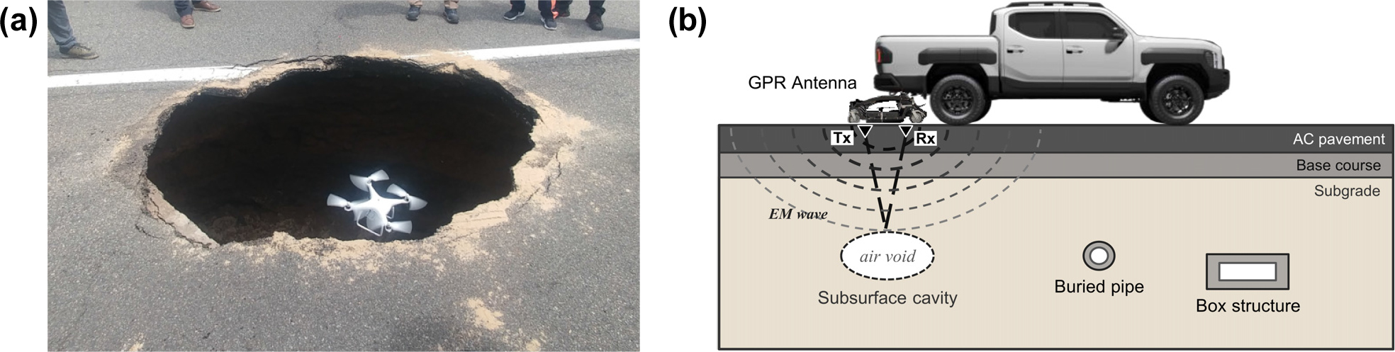
- This study compares four representative repair-stage frameworks—those of Osaka, Seoul, KALIS (Korea Authority of Land and Infrastructure Safety), and the CDI (Cave-in Damage Index)—using 3,054 cavities confirmed by borehole investigation following ground-penetrating radar (GPR) surveys in Busan, Korea. The risk-grade distributions of the four frameworks were compared, and the geomechanical characteristics of each grade were examined using dimensionless cavity-geometry parameters. The frameworks differed substantially in classification, reflecting their distinct assessment philosophies: the KALIS framework was comparatively conservative, assigning more cavities to high-risk grades, whereas the Osaka and CDI frameworks applied a more selective classification, restricting the high-risk category to a narrower range of cavities. Cavity risk was governed primarily by the cover-depth-to-width ratio (η = ht/W) rather than by cavity size: high-risk cavities concentrated at η < 0.4 and low-risk cavities at η > 0.87, consistent with Kuwano’s experimental criterion and Rankine’s theoretical soil-arching limit, respectively. Odds-ratio analysis confirmed that cavities with η < 0.4 were significantly more likely to be classified as high-risk across all frameworks. These field-scale results indicate that η is an effective indicator for cavity risk assessment and maintenance prioritization.
- COLLAPSE
본 연구는 부산 지역에서 지표투과레이더(GPR) 탐사 후 천공 및 공내영상조사를 통해 확인된 도로 하부 공동 3,054개를 대상으로 오사카(Osaka), 서울시(Seoul), 국토안전관리원(KALIS) 및 CDI (Cave-in Damage Index) 등 4개의 위험도 평가체계를 적용하여 위험 등급 분포 특성을 비교하였다. 또한, 공동의 형상 특성을 무차원 지표로 정규화하여 위험 등급과의 관계를 분석하고, 지반역학적 임계값의 현장 적용성을 검토하였다. 평가체계별 위험 등급 분포는 뚜렷한 차이로 도출되었는데, 이는 평가 목적과 의사결정 논리의 차이에 기인한다. KALIS 체계는 상대적으로 많은 공동을 고위험군으로 분류하는 보수적 특성을 보이는 반면, Osaka와 CDI 체계는 고위험군 분류 범위가 좁은 선별적 특성을 나타냈다. 공동의 위험도는 토피 깊이와 공동 폭의 비(η = ht/W)에 의해 주로 결정되었고, 고위험 공동은 η < 0.4에, 저위험 공동은 η > 0.87에 집중되어 각각 Kuwano의 실험적 임계값과 Rankine 토압 이론의 응력 아칭 한계에 부합하였다. 오즈비 분석에서도 η < 0.4 공동은 모든 평가체계에서 고위험 분류 가능성이 유의하게 높았는데, 이는 η가 도로 하부 공동의 위험도 평가와 유지관리 우선순위 결정의 핵심 지표로 활용될 수 있음을 지시한다.
-
Comparative Analysis of Subsurface Cavity Risk Assessment Frameworks and Verification of Geomechanical Thresholds: Evidence from Urban Road Cavities in Busan, Korea
-
Research Article
-
Optimization and Field Validation of a Cam-Driven Hammer-Impact Device for Removing Solidified Calcareous Deposits in Railway Tunnel Drainage Pipes
철도 터널 배수관 내 고형경질침전물 제거를 위한 캠 구동 타격식 장치의 최적화 및 현장 실증
-
Cha Won Kang, Subeen Kim, Nam Seo Park, Hyun Jin In, Seok Hwan Jeong, Minhee Lee, Minjune Yang
강차원, 김수빈, 박남서, 인현진, 정석환, 이민희, 양민준
- Drained railway tunnels frequently suffer from the progressive clogging of small-diameter drainage pipes by solidified calcareous deposits, thereby increasing the lining pore-water …
배수형 철도 터널은 장기 공용 시 소구경 배수관 내부에 고형화된 경질침전물이 축적되어 라이닝 간극수압을 증가시키고 구조물 변상을 가속화한다. 기존의 고압 세척 및 …
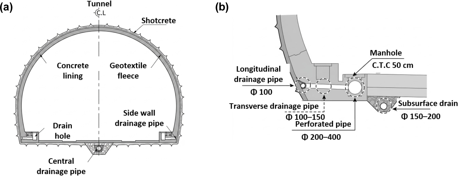
- Drained railway tunnels frequently suffer from the progressive clogging of small-diameter drainage pipes by solidified calcareous deposits, thereby increasing the lining pore-water pressure and accelerating structural deterioration. Conventional high-pressure water jetting and rotary cutting tools have proven insufficient in terms of removing hardened deposits from transverse pipes with diameters below 150 mm. In this study, a cam-driven hammer-impact removal device was developed to convert rotational hydraulic energy into reciprocating linear impact. The optimal nozzle configuration was determined theoretically using the orifice and Darcy–Weisbach equations, and validated through full-scale model experiments. The combination of eight rotor nozzles and three propulsion nozzles with a diameter of 1.5 mm yielded the largest removal area (383 mm2 over 5 min at 10.0 MPa). Under the field-operating pressure of 11.5 MPa, the device delivered a theoretical impact force of 3,073.5 N, approximately twenty times the simple jetting reaction force of 152.9 N, while flexible-body dynamic analysis indicated localized stress concentrations of up to 120 MPa. Comparative tests against a commercial rotary cutter showed an average removal rate of 21.3 cm/min compared with 4.5 cm/min the rotary device. Field application in a 50 m section of an urban subway tunnel successfully restored drainage function, confirming the practical applicability of the proposed technology for railway tunnel maintenance.
- COLLAPSE
배수형 철도 터널은 장기 공용 시 소구경 배수관 내부에 고형화된 경질침전물이 축적되어 라이닝 간극수압을 증가시키고 구조물 변상을 가속화한다. 기존의 고압 세척 및 회전식 커팅 공법은 직경 150 mm 이하 횡배수관 내 고화 침전물에 대해 충분한 파쇄 성능을 확보하지 못하는 실정이다. 본 연구에서는 회전 유체 에너지를 직선 왕복 타격 에너지로 변환하는 캠 구동 타격식 제거 장치를 개발하고, 오리피스 방정식 및 Darcy–Weisbach 식을 이용한 이론적 검토와 실대형 모형 실험을 병행하여 최적 노즐 조합 조건을 도출하였다. 직경 1.5 mm 노즐을 회전체 8개·추진체 3개로 배치한 조건이 5분간 383 mm2의 최대 제거 면적을 보였으며, 실측 운전 압력 11.5 MPa에서 정적등가력 3,073.5 N (단순 분사 반력 152.9 N의 약 20배)이 발생하고 유연체 동역학 해석상 약 120 MPa의 국부 응력 집중이 예측되었다. 상용 회전식 커팅 노즐과의 비교 실험에서 본 장치는 평균 21.3 cm/min의 제거 속도로 기존 장치(4.5 cm/min) 대비 약 5배 높은 성능을 입증하였다. 도시철도 터널 50 m 구간 현장 실증을 통해 배수 기능을 회복시켜 본 기술의 현장 적용성을 확인하였다.
-
Optimization and Field Validation of a Cam-Driven Hammer-Impact Device for Removing Solidified Calcareous Deposits in Railway Tunnel Drainage Pipes

Journal Informaiton
 The Journal of Engineering Geology
The Journal of Engineering Geology


대한지질공학회
Room 4311, Daejeon Universtiy, 62 Daehak-ro, Dong-gu, Daejeon 34520, Korea
Tel: +82-42-280-2737 / Fax: +82-42-280-4575 / E-mail: parkyc@kangwon.ac.kr Copyright© Korean Society of Engineering Geology. Powered by APUB
Tel: +82-42-280-2737 / Fax: +82-42-280-4575 / E-mail: parkyc@kangwon.ac.kr Copyright© Korean Society of Engineering Geology. Powered by APUB